Desertscapes, ocean cliffs, red rocks – it doesn’t take a seasoned traveller to know that Australia is home to some of the best views in the world.
Every state and territory is home to a diverse range of rich scenic grandeur, ready to inspire and excite you. In one of our largest-ever polls, we asked the Australian Traveller community to vote for their all-time favourite views around the country.
Among the readers, tourism operators, local and international travellers, the nominations were eye-wateringly beautiful, and we knew condensing them to 100 would be quite the difficult task. After much deliberation, here are the 100 Best Views in Australia. Enjoy!
100 Best Views – 1 to 10
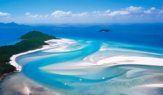
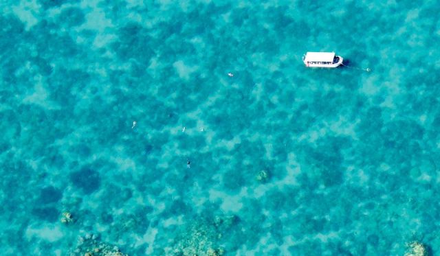
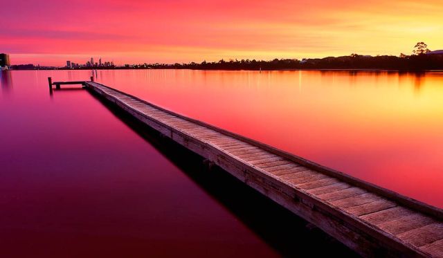
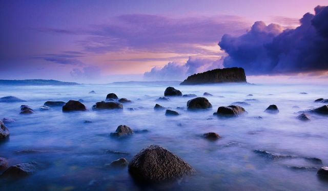
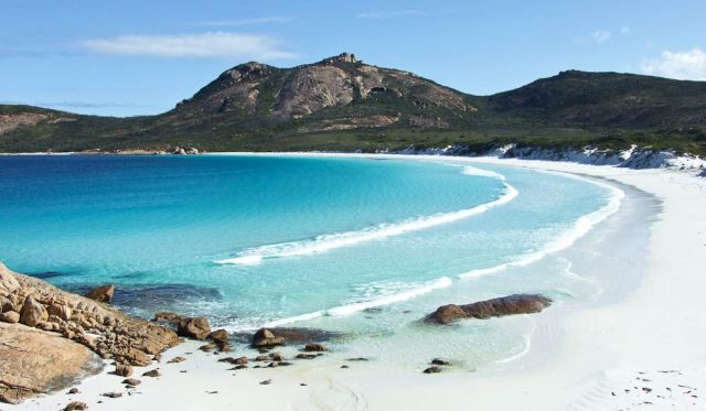
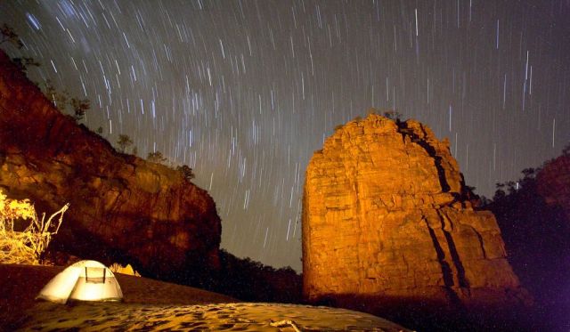
1. Hardy Reef, QLD
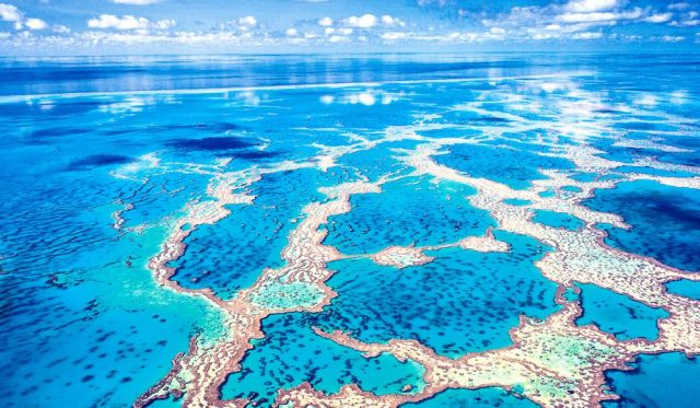
Where is it? The reef is 60km out from Shute Harbour/Airlie Beach
How to see it for yourself?
Most of the Great Barrier Reef’s attractions lie under the surface, of course, and Hardy Reef in its southern section (further from shore and therefore less trafficked) is a great place to see them. Expect a stunning array of polychromatic hard and soft corals, a couple of hundred fish species – including tusk fish, trevally, snapper, cuttlefish, moray eels, barracuda, unicorn fish, surgeonfish, angelfish, wrasse, gropers – not to mention starfish, giant clams and even the occasional passing whale.
But you’ll have to take to the air to see this sight and the other major local attraction, Heart Reef, which is in a protected area off-limits to underwater tourists. Hardy Reef features Fantasea’s permanent Reefworld pontoon, where you can snorkel, dive, do a semi-submersible tour and even stay the night, while further out is Cruise Whitsundays’ Knuckle Reef pontoon. Both offer helicopter flights starting from $110/$129 for 10 minutes.
This image was taken from a chopper at midday. Those with deeper pockets can also fly out from the Whitsunday Islands or the mainland – by helicopter or seaplane – in 30 minutes to save themselves the long boat ride.
Why I love it
“Hardy Reef is probably my favourite part of the Great Barrier Reef, because it features beautiful turquoise colours and incredible textured patterns. This particular view holds significance to me because it was my first ever helicopter flight and aerial photo shoot." – Mark Gray
2. Burra Homestead, SA
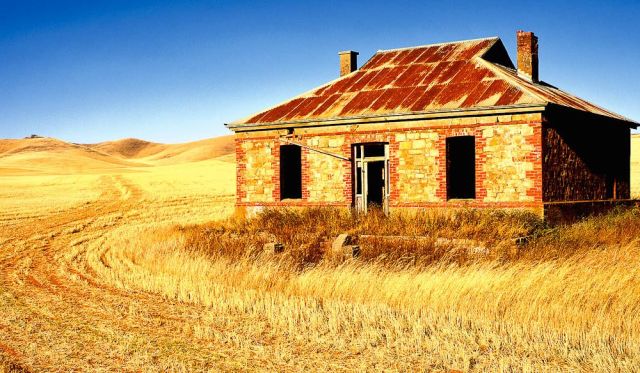
Where is it? Just outside Burra, 160km north of Adelaide
How to see it for yourself?
Famous to Midnight Oil fans for featuring on the cover of Diesel and Dust – also shot by Ken Duncan – this old homestead at the foot of the Mt Lofty Ranges was abandoned long ago by smallholders unable to sustain a livelihood on this rain-starved land.
Ironically, this iconic scene of golden rural Australia is looking a lot greener now after all the recent rain – if you visit in September-October, you might even find it surrounded by canola in bloom, though the crops are rotated.
Hence you might not see this this exact scene. Drive north on the Barrier Highway for 6km from the centre of the historic town of Burra – once a major copper mining centre and also a location used in the filming of Breaker Morant. You’ll see the homestead on your right about 100m off the road. But bear in mind it’s on private property, so unless you ask permission for a closer look, you can only view it from the road. The building faces west so visit in the late afternoon to see it in its best light.
Why I love it
“I first immortalised this old farmhouse in my early days as a landscape photographer. The original shot became one of my most famous images when it was used on Diesel and Dust. How it tickled me when I returned to the area more than ten years later and the local tourist office gave me directions to ‘the Midnight Oil house’!" – Ken Duncan
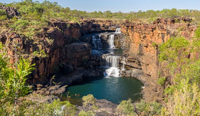
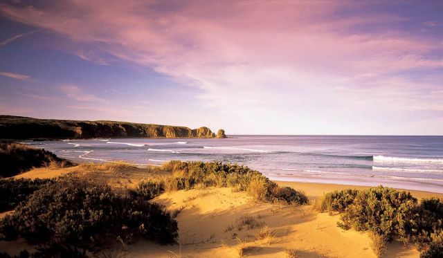
3. The Twelve Apostles, VIC
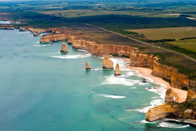
Where is it? Near Princetown, 200km down the Great Ocean Road from Geelong, or 270km south-west of Melbourne
How to see it for yourself?
Constant erosion by wind and sea of the limestone cliffs formed caves and then bridges; when these collapsed – the fate of the nearby Island Archway in 2009 and London Bridge in 1990 – they left these stacks up to 45m high isolated offshore.
They’re a highlight of the Great Ocean Road – probably Australia’s most scenic coastal drive. Note that you can shave 50km off the drive from Melbourne by taking the inland route via the Princes Highway, but then you’d miss out on the other attractions. Formerly called the Sow and Piglets until being renamed the 12 Apostles in the 1920s, they have never numbered 12 – though it depends who’s counting.
Continuing erosion means they could topple at any time, but you can currently see seven stacks to the west of the 12 Apostles viewpoint, and two more to the east. Sunrise – the time this shot was taken – offers the most dramatic lighting from the viewpoint, followed by sunset.
And visit at dawn or hang around after the sun goes down to see little penguins – they come ashore each evening on the beach at the base of the 70m cliffs. If you want to get to the water’s edge yourself, the nearest access is via Gibsons Steps, 1km to the east, but access is restricted.
Why I love it
“People are not normally allowed onto this beach because of the penguin colony, but I was granted special permission and had to be accompanied by a ranger. We arrived in darkness to position ourselves for sunrise; at first light the penguins began to prepare to go out fishing.
First one of the birds came down to the water’s edge to make sure everything was OK, then he signalled to a little troupe of followers to join him. This was mirrored down the entire beach as hundreds and hundreds of penguins began their daily routine. Some of thepenguins actually walked within inches of my tripod. After they had all departed, the moon began to sink towards the horizon and its silvery light illuminated the scene before me." – Ken Duncan
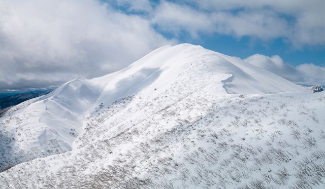
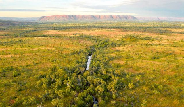
4. Bungle Bungle Ranges, WA
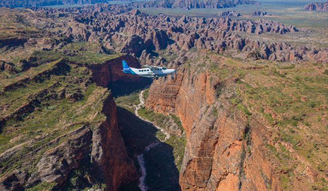
Where is it? Purnululu National Park, WA, 250km south of Kununurra
How to see it for yourself?
You’ll be speechless within seconds of take-off as you’re introduced to Purnululu National Park’s Bungle Bungle Range, a carved 350 million-year-old landscape of gorges and pools surrounded by a soft, green blanket of grassland. Since its discovery in the 1980s, what was once Australia’s best-kept secret is now internationally recognised as a top destination. Because most of the area is inaccessible by car or foot, the best way to appreciate the tiger-striped beehive domes is from a plane or helicopter.
Why I love it
No matter how many times you soar over the Bungle Bungles, they always look different, depending on the time of year, the time of day and prevailing weather conditions. It’s a place you could visit time and again, and we urge you to do it at least once in your lifetime.
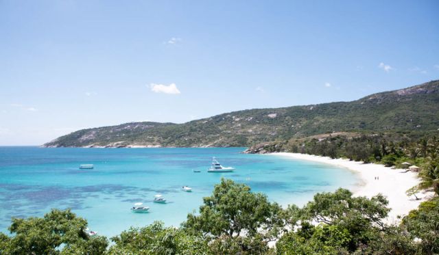
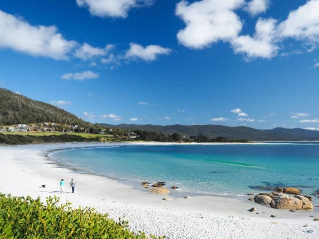
5. Hill Inlet, Whitsunday Island
Where is it? East coast of Whitsunday Island, the largest island in the group offshore from Airlie Beach, between Rockhampton and Mackay
How to see it for yourself?
Access to Whitsunday Island, one of the undeveloped islands in the group that forms the Whitsunday Islands National Park, is usually by boat from Airlie Beach/Shute Harbour or via one of the other island resorts, but there are helicopter/seaplane joy flights if you want to see it from the air like this.
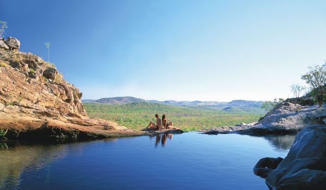
The Whitsundays offer a range of accommodation options from camping to qualia, Hamilton Island’s luxury resort, but the perfect way to experience the islands, reefs and the swirling turquoise water and pure white sands of Hill Inlet is on your own yacht – look into skippered or bareboat hires.
You can anchor overnight at Tongue Bay (at the left of this picture), and walk up to a lookout at Tongue Point for a view over the inlet. Visit at low tide to see the best patterns. Whitehaven Beach stretches 7km south from Hill Inlet and is also worth pointing a camera at: it’s one of Australia’s most beautiful beaches, boasting sand of such purity you could make optical glass from it.
Why I love it
“Great swirls of pure white silica sand sweep and curl through crystal clear waters. The patterns, like those of a kaleidoscope, are everchanging; churned by a moving shaft of silica out to sea. This, to me, is one of the most beautiful locations on the planet." – Ken Duncan
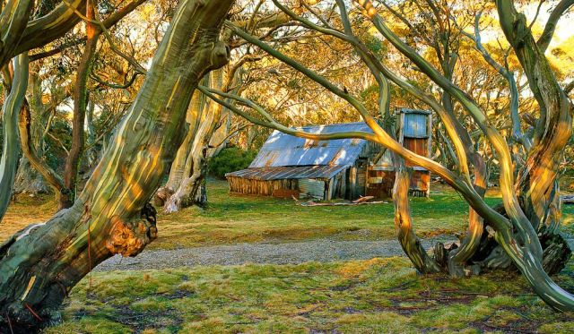
6. Craig’s Hut, Mt Stirling, VIC
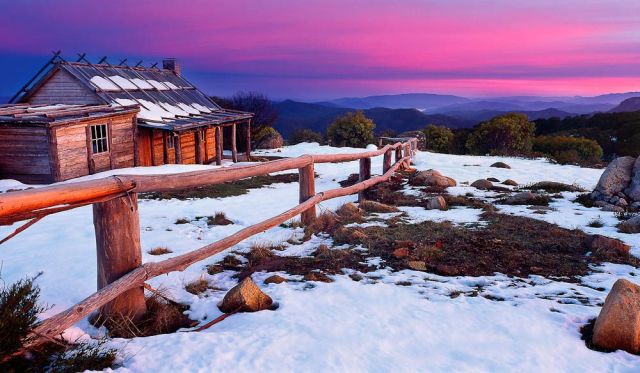
Where is it? In the Australian Alps, 230km north-west of Melbourne
How to see it for yourself?
Drive up towards Mt Buller from Mansfield, then take a left after the Mirimbah tollgate onto Stirling Road.
Then it’s 8km of sealed road to Telephone Box Junction, the limit for vehicles in winter. But in the warmer months you can continue to the gravel by 2WD Circuit Road: turn left and drive for 20km to the junction with Clear Hills Track. From there it’s a 20-minute walk or short 4WD drive to Craig’s Hut.
The spectacular, minimally developed Mt Stirling attracts cross-country skiers, horse riders and bushwalkers. The original Craig’s Hut, inspired by those used by cattle drovers for temporary shelter, was built for the movie The Man from Snowy River (1982) but burnt down in a bushfire.
This replica – with a tin rather than bark roof – was completed in 2008. The shot was taken at sunrise. There are a couple of hundred huts (or their ruins) scattered through the Australian Alps; some built for fishermen, skiers, miners or hydro workers as well as graziers. Most are only accessible on foot/bike/horseback. Wallace Hut near Falls Creek (see number 26 in this list) is thought to be the oldest, built in 1889. A further 2km down the Bogong High Plains Road is Cope Hut, built for skiers in 1929, while Fry’s Hut in the Howqua Hills Historic Area, 34km from Mansfield, is another good example. See the sites below for more information.
Why I love it
“I spent three days camping in the snow at Craig’s Hut with a good friend a few years ago and it was an experience we will never forget. The peace and solitude were incredibly unique. We drank ice-cold water from a nearby stream and built a campfire from fallen tree branches.
Every night we lay awake in our tents trying to figure out what kind of high-country animals made such terrifying noises! Perhaps the rumours of wild cats and panthers have some credibility after all." – Mark Gray
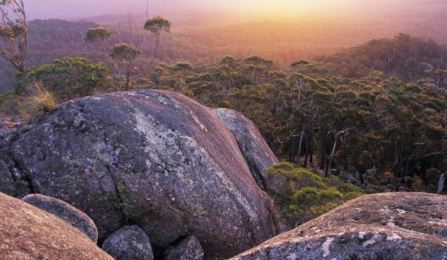
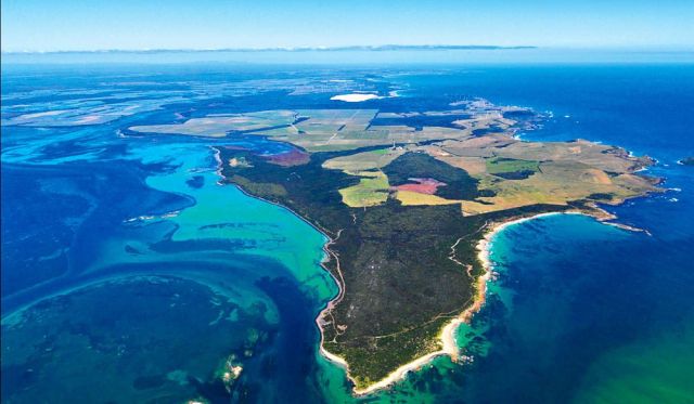
7. Remarkable Rocks, Kangaroo Island, SA
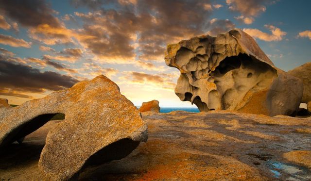
Where is it? Kangaroo Island, which lies 15km off South Australia’s Fleurieu Peninsula
How to see it for yourself?
KI has plenty of natural attractions (see issue #36) – beaches, wildlife, seafood, sheer peace – but these rock formations in Flinders Chase National Park, in the south-western corner of the 150km-long island, are a big draw.
The granite boulders, decorated with orange lichen, sit atop a bald rock outcrop that slopes down into the sea, and have been sculpted with tafoni (deep cavities) – by wind, rain and sea spray. The classic shot of the rocks is taken facing north, but this group is to the south-west. You can get to KI by car ferry or plane.
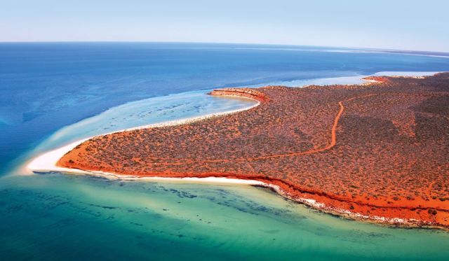
Why I love it
“The balance of the formation really fascinated me; I was especially taken with the ‘open arms’ of the larger stone at the front right of the group. It was as if it was protecting the little rock beneath it, like the enshrouding wings of an angel." – Ken Duncan
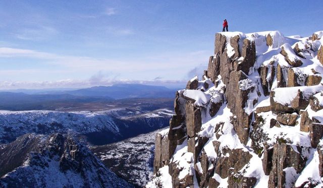
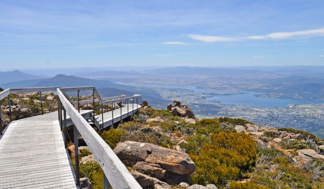
8. Cradle Mountain, TAS
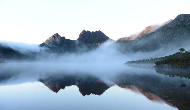
Where is it? Cradle Mountain-Mt Field NP, 90km south of Devonport
How to see it for yourself?
From Dove Lake car park, it’s a two-and-a-halfhour return walk up to Marions Lookout for good views of Cradle Mountain.
Why I love it
“It was a beautiful winter’s day. After getting some shots at the base of Cradle Mountain, I headed back, but after walking for half an hour I decided it wasn’t the right way. I backtracked and looked up to see a full moon rising. I quickly set up my tripod to capture this amazing sight.
I was thinking how fortunate I was that I had taken the wrong track… and then the guide markers disappeared under snow and I became hopelessly lost. I’d started the walk to Marions Lookout at 1pm; it was now 9pm and I was buggered. I sank to my knees and yelled, ‘Help!’ “To my amazement, a male voice replied, ‘Are you right, mate?’ He told me to walk towards his torch. “He introduced himself as Wes Moule and he was going moonlight skiing.
He insisted he guide me back over the next 200m as it was very icy. He said he carried 45kg packs to the walkers doing the Overland Track in summer. I googled Wes later and found he was in remission from cancer, and had vowed that for every kilometre walked carrying the packs he would donate $1 to the W. P. Holman Clinic in Launceston. Wes walked 1220km in 2010-11, and 1170km in 2011-12. I finally made it back to the car park at 10.30pm. The car was frozen over and the road was iced up but I made it home. Then came the hard part: explaining why I was late to my wife!" – Jeff Crow
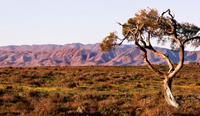
9. Parachilna Gorge, Flinders Ranges, SA
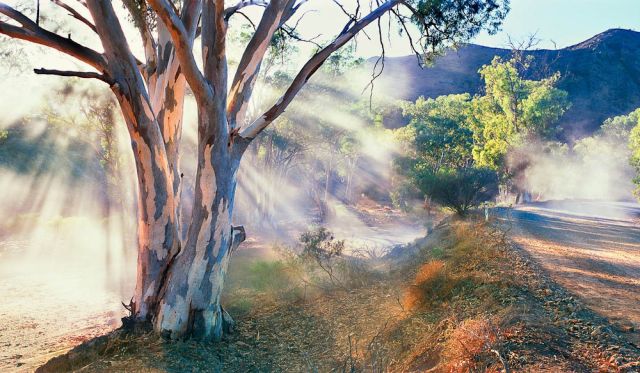
Where is it? East of Parachilna, 200km north of Port Augusta Outside the Flinders Ranges National Park
How to see it for yourself?
Reach this scenic outback gorge by turning right at Parachilna (if approaching from the south) towards Blinman. It’s a dirt road and OK for 2WDs unless it’s been raining and the creeks are flowing. You can camp anywhere in the gorge for free at any time of year, but it’s best seen in spring.
This region is great for 4WDs, with a network of Public Access Routes allowing you to traverse private land – download a map and always check road conditions. Parachilna itself is home to not much beyond the Prairie Hotel, famous for its Flinders Feral Food using local ingredients.
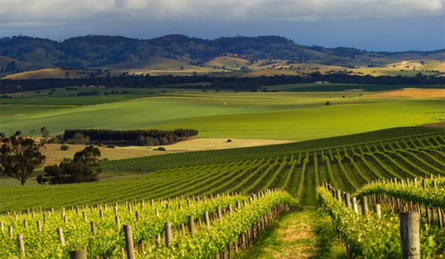
Why I love it
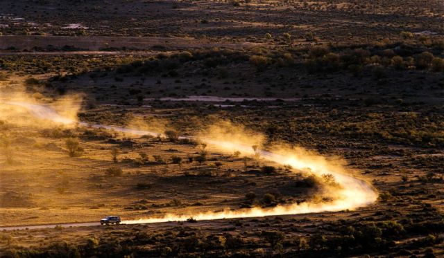
“This is a photo that had existed for years in my mind before it became a reality. Travelling along this road, we were caught in the dust of another car when suddenly I saw the possibilities, so we stopped and set up the camera. I asked my assistant to get back into the vehicle and drive by nice and fast. Much to his delight we had to do it again and again before the dust, the light and the wind came together." – Ken Duncan
10. Cathedral Rocks, Kiama
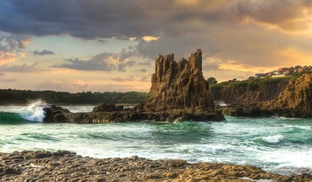
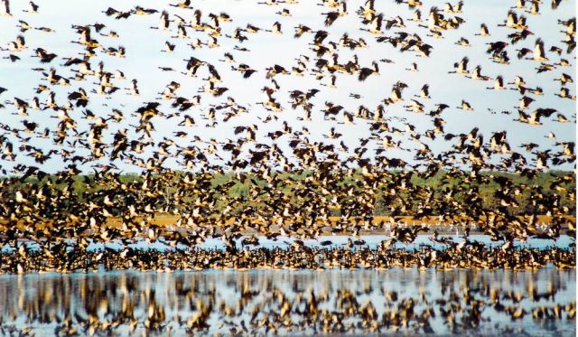
Where is it? Jones Beach, 3km north of Kiama
How to see it for yourself?
Kiama is only 120km south of Sydney and an easy daytrip through the Royal National Park and down the pretty South Coast, but there’s plenty to see in the area to warrant a longer stay. Most visitors are drawn to Kiama’s famous blowhole, another product of the ancient volcanic lava flows that also formed Cathedral Rocks. You’ll find them at the southern end of Jones Beach, and with a little bit of early morning rockhopping you’ll be able to see them from this angle. By the way, don’t confuse this formation with Cathedral Rock in northern NSW.
Why I love it
“Luring sightseers since 1890, the atmosphere at Cathedral Rocks is something else. You get a real beginning-of-time feeling when visiting." – Kieran O’Connor
100 Best Views – 11 to 20
11. West Island, Cocos (Keeling) Islands
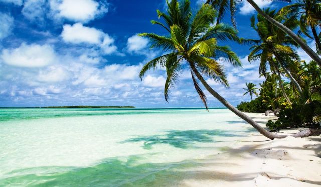
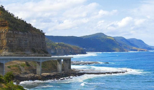
Where is it? The Cocos (Keeling) Islands lie 2750km north-west of Perth in the Indian Ocean
How to see it for yourself?
Virgin Australia flies to the Cocos (Keeling) Islands from Perth via Christmas Island. Comprising the South Keeling Islands (which ring a central lagoon) and the separate North Keeling Island, only two of the 27 islands are inhabited.
These coral atolls were visited by Charles Darwin in 1836 and his studies here contributed to his theory on how coral reefs form. The islands were settled for copra production in 1826 and the small population is descended from the original, mostly Malay Muslim workers.
They voted to become part of Australia in 1984. A quintessential tropical paradise, you come here to dive, snorkel, camp, surf, kite-surf, birdwatch and chill out, not party.
Why I love it
“The image is taken from the south end of West Island looking over the lagoon. Sometimes the water is glassed off, sometimes it’s littered with colourful kite-surfing sails, and sometimes it has the most magical sunsets and moon rises! All together on a beautiful and remote tropical island." – Jules Bush, Cocos Keeling Islands Visitor Centre
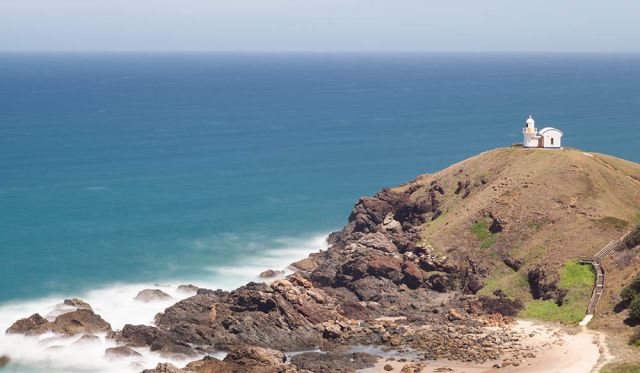
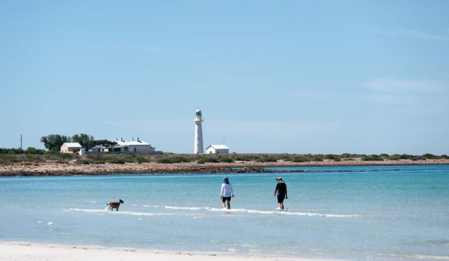
12. Norah Head Lighthouse, NSW
Where is it? About 115km north of Sydney on the state’s Central Coast, the lighthouse can be found at 40 Bush St, Norah Head
How to see it for yourself?
This shot was captured from the north end of Soliders Beach, looking up to the lighthouse, which can be seen in the distance to the left. There are also amazing views from the lighthouse itself. Visitors can have a guided tour around it or even spend the night there, in nearby cottages that were once the lighthouse keeper’s quarters.
Why I love it
“I love the emotion of this scene: the contrast of lights and darks, the newly risen sun in the clouds, the crash of the surf and the shape of the rocks. In the distance stands Norah Head Lighthouse, one of the most recognisable features of the NSW Central Coast. Here its beam farewells the final shadows of night, yet how feeble it appears compared to the glory of the sun." – Ken Duncan
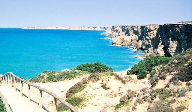
13. Piccaninny Creek, WA
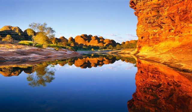
Where is it? Near the NT border 300km south of Kununurra, the creek cuts through Purnululu National Park, past the Bungle Bungles
How to see it for yourself?
This picture was captured at the end of Piccaninny Gorge, which visitors can access on a hike of two to seven days via spinifex-covered grasslands and a lookout over the domes. Walkers must be fully prepared as they’ll encounter fallen boulders and loose rocks, and there is no reliable drinking water along the way. Register at the visitor centre for more info.
Why I love it
“As the sun rises, the awe-inspiring domes of the Bungle Bungles massif are reflected with unwavering precision in the waters of a pool at the end of Piccaninny Gorge. Weathered over millennia into amazing formations of bandedstone, the domes rise like a stupendous city in the remote north-east of WA. This pool, photographed at the end of the wet season, is likely to last only a month or so before the heat dries it to bare rock. But in the meantime, it awaits the dawning of a new day, adding tranquillity to the harsh world it so delicately mirrors." – Ken Duncan
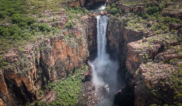
14. Mitchell Falls, WA
Where is it? In the state’s far north, on the western side of the Kimberley, about 15 hours’ drive west of Kununurra
How to see it for yourself?
Mitchell Plateau is accessible by car during thedry season via an unsealed 4WD track off the Gibb River Road, along Kulumburu Road. Continue along it, turning at the Mitchell Plateau Track and drive on to the Mitchell Falls campsite.
It is a 3km walk from the campground to the falls, passing a variety of habitats, waterholes and Aboriginal rock art. To get another perspective of the Mitchell Falls, flight tours of the plateau are available with operators such as Bush Flight and Slingair Heliwork.
Why I love it
“While camping at Mitchell Falls we were surrounded throughout the night by fires lit by National Park authorities to aid the germination of bush seed. This form of environmental care has been practised by Aborigines for millennia. As smoke tempered the early morning light with lovely evenness, the colours of rock and water began to glow. Now as I recall this unrepeatable moment, I think of a line from an old song by The Eagles – ‘call some place paradise, kiss it goodbye’ – and I pray for the preservation of such unique wilderness." – Ken Duncan
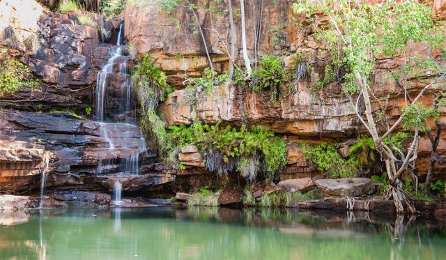
15. Mossman Gorge, QLD
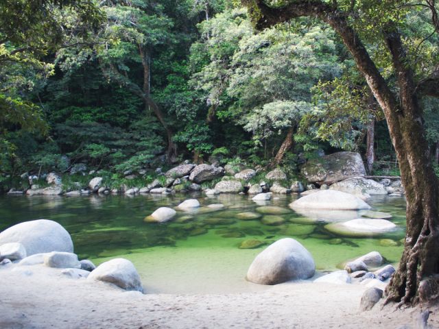
Where is it? In the southern section of the World Heritage-Listed Daintree National Park, about 20km west of Port Douglas in tropical north Queensland
How to see it for yourself?
This image was taken from the base of steps down to the waterhole at Mossman Gorge. The the best way to see this view first-hand is on fivefoot. Guided walks are available, which encompass other sites that are culturally significant to the local Kuku Yalanji people.
The vivid green of the water pictured tends to happen after extended periods without rain. According to the photographer, for ultimate serenity, the best time to visit is early in the morning before the crowds set in.
Why I love it
“Towards the end of the dry season the rapids of Mossman Gorge have usually disappeared. By then, the calm waters offer a perfect place to take a dip and escape the heat of Tropical North Queensland. I really love this view because the shades of green in the water and surrounding rainforest are truly remarkable." – Mark Gray
16. Ormiston Gorge, NT
Where is it? Off Namatjira Drive, 135km west of Alice Springs in West MacDonnell National Park
How to see it for yourself?
This shot of Ormiston Gorge was taken from the banks of the creek, a very short walk from the car park. The visitor centre is about 8km from the Ormiston Gorge turn-off on Namatjira Drive, and although roads are sealed, they can become impassable after heavy rain.
However, the best way to see the gorge is to walk one of the many trails available, ranging from the five minute Waterhole Walk, which has wheelchair access to the end of the paved path, to the Ormiston Pound Walk, which takes up to four hours to complete. For keen hikers, the Larapinta Trail also passes through the area, but it is a challenging long-distance walk that requires careful preparation.
Why I love it
“This is classic Australian outback country. People often think of the centre of Australia as arid, but in the desert there are some beautiful oases and this is one of those places. Where there is water, there is life, as evidenced by these graceful old river gums surrounding the waterhole. The creek is fed by spring water, and really only runs after heavy rain. The rich red walls rising up around the creek turn the gorge into a sanctuary – a beautiful place to go for a swim and find relief from the heat." – Ken Duncan
17. Cape Hauy, TAS
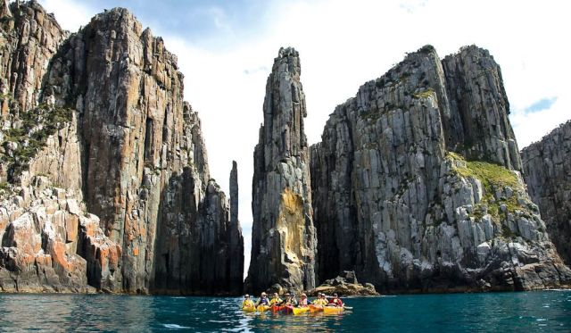
Where is it? Tasman Peninsula, 95km south-east of Hobart
How to see it for yourself?
This view is at the end of the cape, which has a detached sea stack known as the Candlestick. These dolerite seacliffs are among the tallest and oldest in Australia. Kayaking is available with operators such as Roaring 40s Ocean Kayaking. To see it from the land, the Cape Hauy Track is a five-hour return trek that begins in Fortescue Bay, taking in heath and woodland before the views of the cliffs.
Why I love it
“This breathtaking view gives me a genuine feel for untouched wilderness. Even better is the experience of walking along the track through a variety of health and woodland that reaches the magnificent views of steep cliffs and rock formations. The spectacular columns and cliffs surrounded by pristine waters are incredible." – Diane Byrne, Tourism Tasmania
18. Mt Feathertop from Mt Hotham, VIC
Where is it? In the heart of the Australian Alps National Park, 385km north-east of Melbourne
How to see it for yourself?
You can drive to Hotham, at the crest of the Great Alpine Road – the highest bitumen road in Australia. There are also several coaches that service the area, such as Christian’s Bus Co and O’Connell’s Omeo Bus Service. Otherwise, Hotham’s airport is serviced by QantasLink from Sydney in peak season – the flight takes 80 minutes – and charter flights from across Australia year round, and is a handy 20km from the slopes.
But while snow-based activities are popular during the winter months, in summer the landscape transforms into grassy mountain ranges speckled in wildflowers. Various tracks and trails thread through them, ideal for hiking, biking and horse riding.
Why I love it
“This is one of the most stunning views I have ever seen. To me, this view looking out onto Mt Feathertop is perfect no matter what time of day or year. Whether it is covered in snow or surrounded by blue skies, it can be admired and enjoyed all the time. The sunset here will take your breath away. Views like this make working at Hotham worthwhile." – Ruth Appleyard, Mt Hotham Skiing
19. Tantabiddi Sanctuary Zone, WA
Where is it? The centre of Ningaloo Reef, which skirts Cape Range Peninsula, west of exmouth and 1265km north of Perth
How to see it for yourself?
This is a shot of the Reefviewer glass-bottomed boat in the centre of the sanctuary. Tantabiddi covers only four square kilometres but is home to a wealth of marine life such as green sea turtles, estuary cod, parrotfish and clownfish. Ningaloo Ecology Cruises offers boat and snorkelling tours in the sanctuary, while Birds Eye View offers microlight flights for great aerial views like this.
Why I love it
This is my office! The beauty of World Heritage listed Ningaloo Reef never ceases to amaze me. With many years on the job as a captain of the boat pictured, this image made me realise again how lucky I am. Observing people’s excitement especially kids – is priceless. It stresses the responsibility to pass it on to my children in its stunning untouched state." – Alek Nowak, Ningaloo Ecology Cruises
20. Cook’s Look, Lizard Island, QLD
Where is it? Australia’s northernmost island, a 1 hour flight of Cairns.
How to see it for yourself?
After taking the flight to Lizard Island from Cairns, Cook’s Look can be accessed via a 4 kilometer steep hike to the vantage point. There, panoramic views of the island can be enjoyed, in between snorkels of the Great Barrier Reef of course.
Why I love it
“To call Lizard Island paradise feels like a gross understatement. Rocky outcrops of granite. Dry, sparsely vegetated hills. A pleasing barrenness tumbling down to coral-white beaches and aquamarine waters, this lookout encompasses the best of this dry island, which in many ways is reminiscent of the Greek islands in the Aegean Sea" – Eliza Sholly, Deputy Digital Editor of Australian Traveller
100 Best Views – 21 to 30
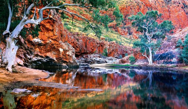
21. Finke River Lookout, NT
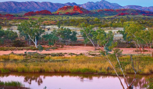
Where is it? Near Glen Helen Resort, 130km west of Alice Springs on Namatjira Drive
How to see it for yourself?
The ancient, 600km Finke River rarely flows and is often just a series of waterholes. There’s a permanent one in the gorge at Glen Helen in West MacDonnell National Park, which is also one of the few points where you can access the river by sealed road. Glen Helen Resort has motel-style accommodation and camping.
Why I love it
“This scene – typical of the country that inspired Albert Namatjira – was shot near Glen Helen. It was one of those rare occasions when the Finke River was flowing here. I had already packed up for the day when, suddenly, I saw the sky beginning to colour beautifully. I raced back out just in time to shoot this spectacular view." – Ken Duncan
22. Bicheno, TAS
Where is it? On Tasmania’s East Coast above Wineglass Bay, 180km north-east of Hobart.
How to see it for yourself?
This photo is taken directly in front of Diamond Island Resort, at 69 Tasman Highway, about 2km north of central Bicheno, looking north up the coastline.
Why I love it
“The feeling I get from sitting on a rock and taking in the views of this magical sheltered bay is something special. Its natural beauty and spectacular landscape offer the most peaceful setting where I can totally relax, reflect and think positive thoughts about the wonderful life I lead." – Diane Byrne, Tourism Tasmania
23. Hamersley Dunes, WA
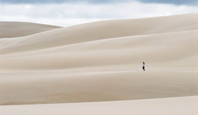
Where is it? In The Fitzgerald River National Park, 550km south-east of Perth between Albany and Esperance
How to see it for yourself?
Fitzgerald River National Park contains more than 1800 plant species, 62 unique to the park, and more animal species than any other park in Australia. There are entry points on both sides: from the western side via Bremer Bay, or the eastern side via Hopetoun. The central area of the park, however, is only accessible by 4WD or on foot.
Why I love it
“Fitzgerald River National Park has incredibly diverse scenery. The Hamersley Dunes are just like a white-sand Sahara. There’s 4WD access and great fishing here, but the best catches are often what you capture through the lens." – Elisabeth Knowles, editor, Australian Traveller
24. Uluru, NT
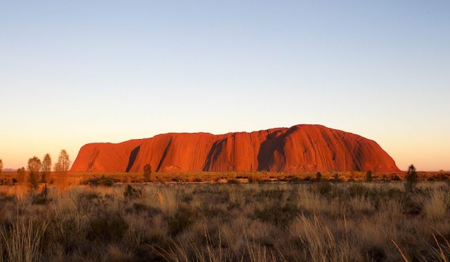
Where is it? Off the Lasseter Highway, 450km south-west of Alice Springs
How to see it for yourself?
The easiest way to see this sacred monolith is to fly direct to Ayers Rock Airport (Yulara), which is about 22km north of Uluru. Alternatively you can drive or catch a tour bus from Alice Springs with an operator like Travel Aust (travelaust.com.au), which offers daily transfers.
Why I love it
“Indigenous Australians believe Uluru to be the centre of all Dreaming. Traditionally, this area was seen as something like the hub of a wheel, with songlines radiating from it across the land. I believe Uluru is a place that is special for all Australians. I would even go so far as to say that I believe a new ‘song’ is coming – a song of unity and reconciliation between the different cultures of our nation – that will spread powerfully through the rest of the land." – Ken Duncan
25. The Pinnacles, WA
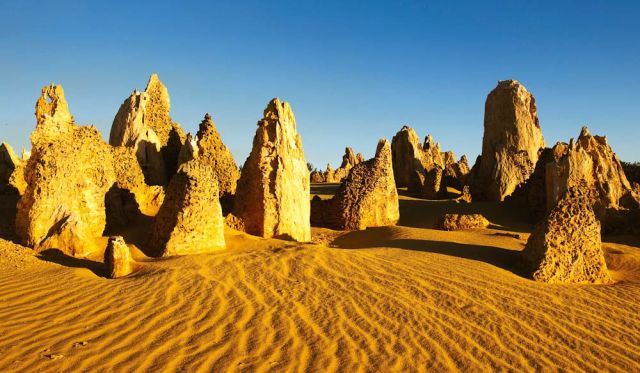
Where is it? Nambung National Park, 230km north of Perth
How to see it for yourself?
Vehicles can access Nambung National Park from the north via Cervantes, or from Perth on the scenic Indian Ocean Drive. Access to the Pinnacles area itself is via a 1.2km marked walk trail or a 4km drive through the park. Visit the Pinnacles Lookout for a more elevated view.
Why I love it
“Regarded as one of Australia’s most unique landscapes, the Pinnacles Desert features thousands of golden limestone spires rising eerily out of the sand. You can get up close to the Pinnacles, some of which are several metres high, on a scenic drive or walk." – Grace Pappelendam, Australia’s Coral Coast
26. Wallace Hut, VIC
Where is it? Near Falls Creek, 375km north-east of Melbourne
How to see it for yourself?
By car, follow Bogong High Plains Road from Falls Creek towards Omeo – the road is sealed but closes during the winter season, so be prepared. Follow the road for about 7.5km and park at the signposted entrance. From there it is an easy 750m walk to the hut.
Why I love it
“This photograph celebrates an era of legends, when cattlemen roamed the high country of Australia’s southern range. This hut was one of the men’s old ramshackle resting places. It is captured here in the first light of morning between the spreading snow gums, a scene both of beauty and nostalgia.
The good sense of those days is highlighted by the horrendous fires which now so often threaten these protected places. The cattle which once kept the undergrowth in check are gone. Many people (myself included) believe they should now be allowed back." – Ken Duncan
27. Carisbrooke Station, QLD
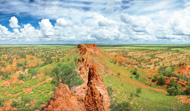
Where is it? Off Cork Mail Road, 85km south-west of Winton, 970km west of Rockhampton
How to see it for yourself?
From Winton, follow Kennedy Development Road in the direction on Boulia, then turn left at Cork Mail Road for 45km and the entrance to Carisbrooke Station is on the left. The station also has a 1100m airstrip, with light aircraft flying to Winton. This view was taken from the top of an escarpment that runs parallel to Jundah Road, bordering the back of the property, looking back towards the station. The escarpment reaches 80m in places, giving great views area. It can be accessed by car from Carisbrooke, but it can be limited during the wet season.
Why I love it
“The colours are breathtaking; reds, ochres, whites and shades of green, topped by the clearest of blue skies. During the wet everything is saturated, so the colours seem to “pop" so much more. One can easily find a spot to sit all day to contemplate life and marvel at the beauty of this time-sculpted, ancient landscape." – Ziggy Ziegler, The Resort
28. Lake Oberon, TAS

Where is it? The Western Arthur Range, 90km south-west of Hobart in SouthWest National Park
How to see it for yourself?
This picture was taken looking north-west in the 15km-long, 22-peak Western Arthurs, south of Lake Pedder in the Tasmanian Wilderness World Heritage Area. You access the range from Scotts Peak Dam on a challenging walk of two to three days, or longer to traverse the whole range. Tasmanian Wilderness Experiences offers guided walks through the Western Arthurs.
Why I love it
“I love the breathtaking scenery in this magical part of the Tasmanian wilderness. I can easily spend time watching the wildlife, admiring the scenery and taking a few leisurely walks along the way. This is truly a special place that I can never remove from my mind." – Diane Byrne, Tourism Tasmania
29. Bay of Fires, TAS
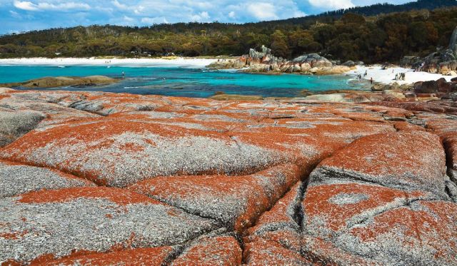
Where is it? On Tasmania’s north-east coast, 275km north of Hobart How to see it for yourself
How to see it for yourself?
From St Helens (where you should buy food and fuel if camping), take Binalong Bay Road to the signposted turn-off to The Gardens, a hamlet at the northern end of the Bay of Fires Conservation Area. This is a 13km stretch of coast down to Binalong Bay that forms the southern section of the Bay of Fires.
Why I love it
“The landscape is so wild and beautiful. Red lichen-covered rocks contrast brilliantly with white sand and turquoise water, and there is so much animal and bird life. If you want a total change from the city, this is the place I’d recommend." – Elisabeth Knowles, editor, Australian Traveller
30. Devils Marbles, NT
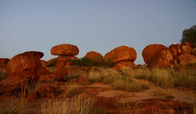
Where is it? Just off the Stuart Highway, near Davenport, 395km north of Alice Springs and 760km south of Katherine
How to see it for yourself?
Known as Karlu Karlu and a sacred site to the traditional Aborginal owners, the Devils Marbles can be explored on foot after a short drive off the highway. There is a 15-minute self-guided walk commencing at the car park, as well as a network of other tracks. During the cooler months, guided walks and talks are available – contact the Tennant Creek Visitor Information Centre for details.
Why I love it
“As a strange collection of boulders strewn across a spinifex valley in imposing, sometimes impossible positions, the Devils Marbles is unlike anything else. Made of granite and rounded by erosion, its official name implies a diabolical origin – as if the devil had thrown them down with mischievous carelessness. I prefer to think of them as the handiwork of a Creator who does nothing haphazardly." – Ken Duncan
100 Best Views – 31 to 40
31. The Great Ocean Walk/Cycle Way, WA
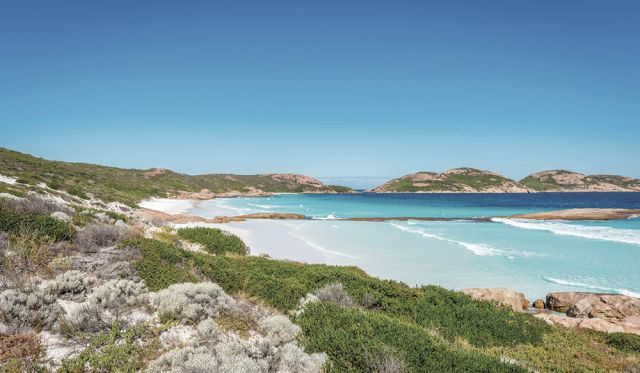
Where is it? Esperance, 730km south-east of Perth
How to see it for yourself?
The 15km walking and bike trail commences at Castletown Quay and follows the foreshore through Esperance, taking in the Esplanade, Rotary Lookout, West Beach and Blue Haven and finishing at Twilight Beach.
Sections can be accessed from car parks along its length. This view is from the car park at Salmon Beach, about 11km along the trail. There’s a 40km Great Ocean Drive, too, from the Cannery Art Centre along the coast to Observatory Point, Nine Mile beach and Ten Mile Lagoon before looping inland to Pink Lake and the Glass Gallery.
Why I love it
“The path is very popular with tourists and locals. The beaches around here are used regularly for swimming; the walk trail is great for cycling and is also used for triathlons." – Tahnee Adamson, Esperance Visitor Centre
32. Overland Track, TAS
Where is it? Tasmania’s central north wilderness, From Cradle Mountain in the north to Lake St Clair to the south
How to see it for yourself?
This spectacular 65km, six-day walk is very popular and must be booked in the summer peak, November 1 to April 30, when you can only walk north to south.
Private cars can be parked at both Cradle Mountain and Lake St Clair ends. Otherwise bus operators such as Tassielink and McDermotts Coaches, service both ends from major towns. This particular shot was taken from the summit of Cradle Mountain itself.
Why I love it
“Nothing compares to the uniqueness of this view – the glacier-carved landscape decorated with tannin-stained lakes, the soaring peaks, and the plunging gorges. It’s amazing to see the stark alpine plains and hear the silent green rainforests. The range of plant species – including the fagus, one of Australia’s few native cold-living deciduous trees – is another remarkable feature of this region." – Diane Byrne, Tourism Tasmania
33. The Daintree from Myall Beach, QLD
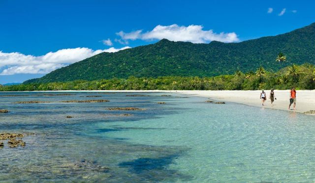
Where is it? Cape Tribulation, 120km north of Cairns
How to see it for yourself?
Just opposite Cape Tribulation Camping, Lot 11 on Cape Tribulation Road, is the Dubuji Boardwalk. The boardwalk leads directly to Myall Beach where this view can be seen when looking south. This pristine beach has a fringing coral reef that’s exposed at low tide: a great place to explore the rockpools.
Inviting as it looks, you can’t swim here in summer stinger season. It’s also one of the many Tropical North Queensland beaches where the Daintree rainforest fringespristine white sand.
Why I love it
“Cape Tribulation is where the rainforest meets the reef." – Dale Flack, Tourism Tropical North Queensland
34. Christmas trees at Cape Le Grand National Park, WA
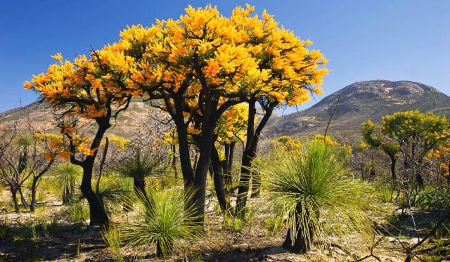
Where is it? On WA’s south coast, 50km east of Esperance
How to see it for yourself?
The WA Christmas tree, Nuytsia floribunda, produces spectacular flowers in summer but is rarely found outside the south of the state. Visitors can self-drive to the park by car and see the park’s wildflowers, fauna and idyllic beaches, but for local knowledge and expert advice, try a guided tour such as with Esperance Eco- Discovery Tours.
Alternatively, Aussie Bight Expeditions runs wildflower tours during spring.
Why I love it?
“Native Christmas trees are so vibrantly coloured, and when you pair them with clusters of tuftyheaded grass trees, the landscape takes on the aspect of a Pixar-created prehistoric world." – Elisabeth Knowles, editor, Australian Traveller.
35. Deep Water Point, WA
Where is it? Overlooking the Canning River in Mount Pleasant, 10km south of Perth’s CBD
How to see it for yourself?
This shot was captured at sunrise from the sand right next to Deep Water Point Jetty. Get there at least 20 minutes before sunrise to see the colour changes in the sky.
Why I love it
“Deepwater Point is my favourite location to visit in Perth, especially at sunrise. The jetty is a unique structure and points directly at the city, making for great photographs." – Mark Gray
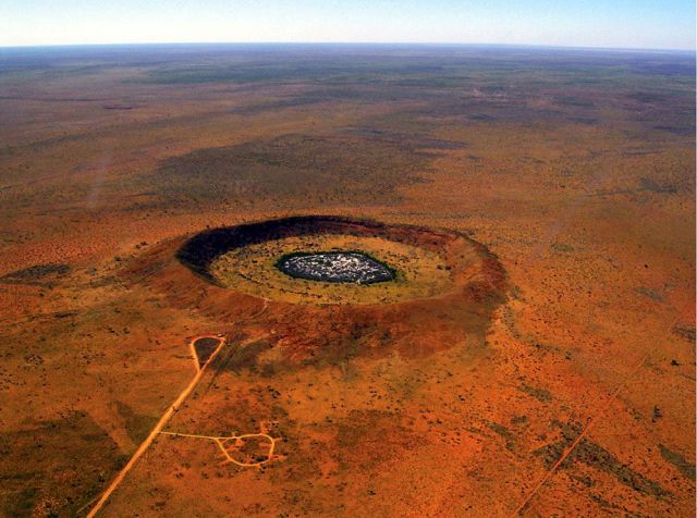
36. Lake Ballard, WA
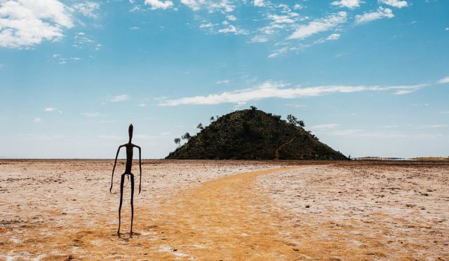
Where is it? 51km west of Menzies, 680km north-east of Perth
How to see it for yourself?
Follow the Goldfields Highway from Kalgoorlie to Menzies before turning left at a well-signposted service station onto a gravel road heading northwest.Continue a further 50km to the sign posted turn to Lake Ballard car park. From there, visitors can walk throughout the 10-square-kilometre salt lake, featuring the Inside Australia exhibit by Antony Gormley.
There are 51 sculptures in total, said to represent local members of the community. This shot was taken near the visitor entrance and shows Snake Hill in the background, about 600m from the lake edge.
Why I love it
“When you get there you realise it isn’t just the sculptures that you are viewing – the whole setting is an artscape. As you walk from one sculpture to the next you leave footprints on the salt, which is part of the artwork; man connected to man, connected to the environment. This is a magnificent art site in a magnificent location." – Jac Eerbeek, Australia’s Golden Outback
37. Eagle Falls, WA
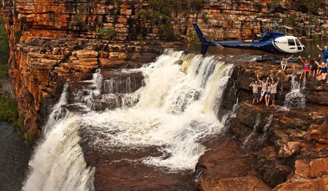
Where is it? On the Drysdale River in The Kimberley, WA
How to see it for yourself?
The only way travellers can access Eagle Falls is via a helicopter flight with North Star Cruises, aboard the expedition ship True North. It offers a number of scenic flights around the area, including a five-star picnic package onsite.
Why I love it
“This view perfectly shows the epic landing area for the helicopter and how close the falls are to where we land. It is sometimes hard to get a feeling of scale with such shots. The river was flowing especially well on this occasion so it was spectacular. You can also see how excited the passengers are to be there." – Mark Stothard, True North director
38. El Questro Homestead, WA
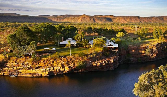
Where is it? Coolibah Drive near Kununurra, in The Kimberley, 830km south-west of Darwin
How to see it for yourself?
This stunning view was taken on board an El Questro scenic flight. The experience takes visitors above the homestead in an open-door helicopter ride, over the Cockburn Ranges andthrough the Pentecost and (pictured) Chamberlain Gorges. A 30-minute scenic tour starts at $280 per person.
Why I love it
“The amazing contrast of the Chamberlain River with the rugged landscape of the Cockburn Ranges in the background – simply breathtaking." – Joseph Boulos, Delaware North Australia Parks and Resorts
39. Genoa Peak, VIC
Where is it? Croajingolong National Park, Gippsland, 500km north-east of Melbourne
How to see it for yourself?
Turn off the Princes Highway at Genoa Peak Road, west of Genoa. Travel 8km to the car park and picnic area. From there, take a 1.5km return walk to the summit (allow an hour each way). A steel ladder gives access to the viewing platform.
“Croajingolong National Park is a UNESCO World Biosphere Reserve, which means there is an effort to preserve the landscape in such a way that people can discover it and enjoy it without destroying it. Standing at Genoa Peak is a supremely peaceful experience." – Elisabeth Knowles, former editor, Australian Traveller
40. Gunlom Falls top pool, NT
Where is it? Waterfall Creek in Kakadu National Park, 315km south-east of Darwin
How to see it for yourself?
Gunlom Falls are accessible by 4WD vehicles along the Gunlom Track, near the southern entrance to Kakadu National Park. Drive carefully as the track is unsealed, subject to flooding and sandy in areas. It is impassable in the wet season but open between May and October. Once there, visitors can swim at the base of the falls or take the walking track to the top where there are more swimming holes – and where this view was taken. The walking track is steep, uneven and suitable for people with a medium level of fitness. Remember to take plenty of water for the trek.
Why I love it
“It’s the magical combination of a waterfall and serene plunge pool, with shady gums cooling the picnic areas. A steep climb to the top of the waterfall provides sweeping views of the southernmost parts of Kakadu National Park while you enjoy a relaxing dip in the crystal-clear pools." – Nelson Hall, Tourism NT
100 Best Views – 41 to 50
41. Horse Muster, Glenworth Valley, NSW
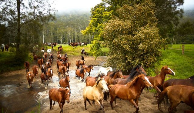
Where is it? Central Coast Hinterland, 65km north-west of Sydney, at Glenworth Valley Horse Riding, 69 Cooks Road, Peats Ridge
How to see it for yourself?
This view is taken at the Popran Creek crossing, in front of the main horse riding complex at Glenworth Valley. However, the best way for visitors to see the running in of the horses each morning is to camp the night so you are there in time. The paddocks the horses are kept in overnight are regularly rotated, meaning their route can vary. Check with staff for information on the safest location to view them.
Why I love it
“The daily mustering of the property’s 200 horses is a sight to behold. The ground shakes as the horses run through the morning fog and splash through the waters of Popran Creek and up the bank towards the yards, ready for a day of transporting guests along 50km ofprivate riding trails. It’s a ritual that has been done here for over 40 years." – Nicole Hain, Glenworth Valley Outdoor Adventures
42. Merimbula Lake, NSW
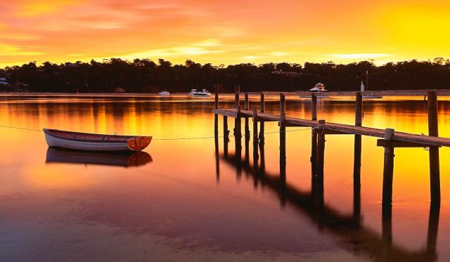
Where is it? Bordering the southern edge of merimbula on the South Coast, 450km south of Sydney
How to see it for yourself?
The view pictured was taken at sunrise while standing on the banks of the fishpen, located on the southern side of the bottom lake.
Why I love it
“In today’s world it is rare to find old, run-down jetties. They are usually quickly replaced with brand-new structures to avoid public liability issues. Merimbula Lake is one of the last few locations remaining in Australia that feature a variety of these old jetties. This makes it a photographer’s paradise, particularly during sunrise and sunset. I have spent countless hours at Merimbula Lake and have witnessed some incredible lightshows. This amazing sunrise occurred immediately after a rainstorm." – Mark Gray
43. Rangoon Island, NSW
Where is it? Just offshore from Minnamurra on the South Coast, 115km south of Sydney
How to see it for yourself?
Follow the Princes Highway south from Sydney towards Kiama before taking the Riverside Drive exit and following signs to Rangoon Reserve. With the Minnamurra River dividing the township from the ocean, visitors can access the beach closest to the island by boat. Otherwise, at the ar end of the beach is a car park with a rough walking track down to the sand. It is at this far end with many rocks that this view was taken.
Why I love it
“Shot at sunrise, Rangoon Island rises out of the water with a certain mystery surrounding it; I always feel a certain sense of peace when visiting it." – Kieran O’Connor
Image by Kieran O’Connor
44. Sir John Range, WA
Where is it? Mornington Wildlife Sanctuary, 550km north-east of Broome
How to see it for yourself?
At 3207 square kilometres, Mornington Wildlife Sanctuary is one of the largest non-government protected areas in Australia. The Mornington Wilderness Camp has ten safari-style tents and is open to visitors from May to October. It is accessible by 4WD or private air charter only. By 4WD, follow the Gibb River Rd 330km from Derby. Turn off at Mt House and continue south for 88km. If you’d like to capture this view, take a scenic flight out of Broome with King Leopold Air.
Why I love it
“The landscape is spectacular – dramatic mesas, cut by valleys and gorges, overlooking expansive plains and a network of rivers and streams. This amazing 312,000-hectare nature reserve is home to a diversity of wildlife, including endangered species such as the Gouldian finch. The view is all the more special knowing that Mornington is the only property in northern Australia to record an increase in native mammal populations." – Catherine Harper, Australian Wildlife Conservancy
45. Southern Ocean Lodge Kangaroo Island, SA
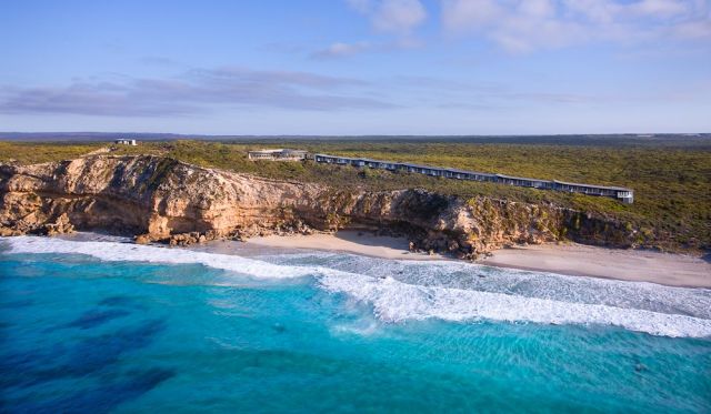
Where is it? Hanson Bay Road, Kingscote; Kangaroo Island is 250km southwest of Adelaide
How to see it for yourself?
While it was gutted by the horrific bushfires of early 2020, this incredible lodge is due to bounce back – and the views here are still amazing. Guests at the luxurious Southern Ocean Lodge have access to the star-gazing platform pictured, which overlooks Hanson Bay while being just a short minute’s walk along the boardwalk from the lodge.
Why I love it
“The view over Hanson Bay from the clifftop boardwalk is, quite simply, cinematic. The enormous spirit of the Southern Ocean inspires both awe and contemplation – an ever-changing mood reflects centuries of interaction between man and nature, sometimes nurturing, often wild, but always big. Enjoyed with a glass of South Australia’s finest wine in hand, it doesn’t get any better than this!" – Louise Lanyon, Southern Ocean Lodge
46. Z Bend Lookout, WA
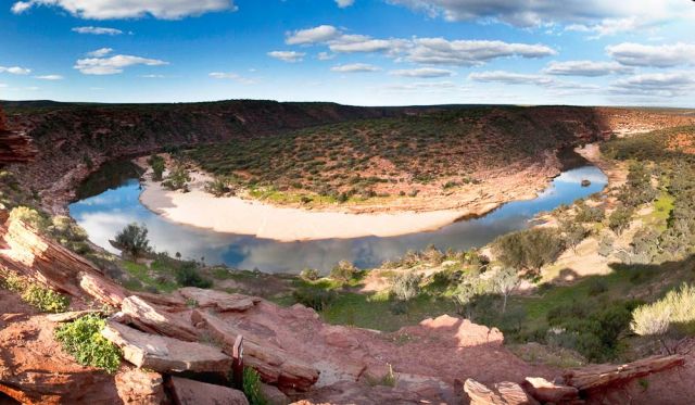
Where is it? Murchison River gorge, Kalbarri National Park, 585km north of Perth
How to see it for yourself?
From the Kalbarri National Park car park, the lookout can be reached via a 500m walking track. Gazing down, the gorge walls plunge 150m to the river below, where river red gums create a striking contrast against the earthy Tumblagooda sandstone. Kalbarri Tours offers tailor-made group charters to the gorge, as well as canoeing tours for more adventurous types.
Why I love it
“Named after the enormous Z bend created over time by the Murchison River, the lookout offers views that will spellbind visitors. There are these dramatic sandstone cliff faces which plummet into the river as it meanders through Kalbarri. Abseiling provides a particularly thrilling view!" – Grace Pappelendam, Australia’s Coral Coast
47. Cape Woolamai, VIC
Where is it? The south-east tip of Phillip Island, 130km south-east of Melbourne
How to see it for yourself?
At the south-eastern tip of the island, this is also its highest point. Turn off Phillip Island Tourist Road and down Woolamai Beach Road; park at Woolamai Beach Surf Club. From there, walk up the beach to Magic Lands and take the inland boardwalk, which has several routes around the cape of 2-4km return. The view pictured was taken from Woolamai Beach looking east.
Why I love it
“There is nothing as striking as walking to the entrance and taking in the breathtaking expanse of beach and ocean, which starts with the spectacular Pinnacle rock formations." – Kim Storey, Destination Phillip Island
48. Macquarie Lighthouse, Sydney, NSW
Where is it? Old South Head Road, Vaucluse
How to see it for yourself?
The lighthouse is located near The Gap on South Head, 10km east of the CBD. Walk through Signal Hill Reserve, heading south, and after about 200m the view of the lighthouse and cliff will appear.
Why I love it
“It’s one of the most spectacular views in Sydney during a thunderstorm. A walk along the cliff is must-do, no matter if it rains!" – Hartmut Toepler, photographer
49. Wineglass Bay, TAS
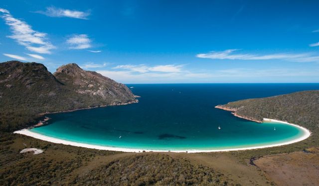
Where is it? Freycinet National Park, 195km north of Hobart
How to see it for yourself?
This view is from the summit of Mt Amos, part of the granite mountains known as The Hazards. It is a strenuous three-hour return hike up. If you don’t want to tackle it alone, consider a guided hike such as Travelwild Tasmania Tours.
Why I love it
“This is one of my favourite spots where I can totally relax. Breathtaking views encompass the white sandy beach and crystal clear seas. At the southern end The Hazards provide a magnificent backdrop." – Diane Byrne, Tourism Tasmania
50. Russell Falls, TAS
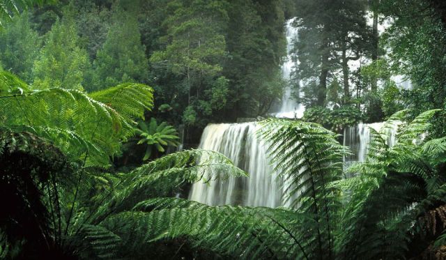
Where is it? In Mount Field National Park, 85km north-west of Hobart
How to see it for yourself?
Just a 10-minute stroll from the Mt Field National Park Visitors Centre, Russell Falls can be accessed via a sealed path suitable for wheelchairs. The walk will also take you past some of the tallest hardwood trees in the world. Return by the same track or cross a bridge below the falls and follow the creek back.
Why I love it
“This unusual, angled view of the dramatic, twotiered Russell Falls has become quite famous, appearing in National Geographic and several other international magazines. I had to balance out on a tree limb to capture the cascade you see here. This shot was taken soon after rainfall, giving the majestic old tree ferns their lush green colouring." – Ken Duncan
100 Best Views – 51 to 60
51. Balloons Over Lake Burley Griffin, ACT
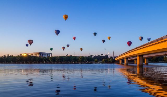
Where is it? Canberra
How to see it for yourself?
These balloons are taking part in the annual Canberra Festival Balloon Spectacular. However, rides can be booked at any time of year with operators such as Balloon Aloft and Dawn Drifters.
Why I love it
“Rising above it all at dawn in a balloon is one of the most memorable, shifting views. Canberra is one of the few capital cities people can fly over to appreciate the geometry of the city’s design." – Kathy Tricolas, Australian Capital Tourism
52. Cape Grim from the air, TAS
Where is it? 270km from Launceston, on Tasmania’s North-West Tip
How to see it for yourself?
Here, you see Woolnorth Point in the foreground, Cape Grim facing to the right and Mt Cameron and Marrawah in the distance. To see it, book a flight with local helicopter operator Osborne Aviation Services or experience it on foot with Woolnorth Tours.
Why I love it
“Cape Grim was shot on a perfect day – at midday on a full tide, with no wind, smoke or heat haze, and the grass was green after recent rain." – Peter Bellingham, photographer
53. Flinders Ranges in Spring, SA
Where is it? The Australian Arid Lands Botanic Garden in Port Augusta, SA
How to see it for yourself?
Drive along the Stuart Highway in Port Augusta, about 310km north-west of Adelaide.
Why I love it
“This is my big backyard; it’s ancient, majestic, beautiful, impressive, illusive, fascinating, inspirational and spiritual." – Georgie Sharp
54. Gordon River, TAS
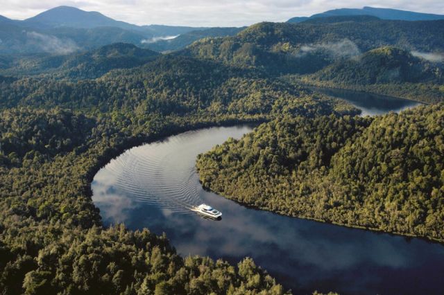
Where is it? The Franklin-Gordon Wild Rivers National Park in Tasmania’s south-west
How to see it for yourself?
This is at the Franklin end – near the first section of the Frenchman’s Cap trail. To be on the water, take a scenic cruise with Gordon River Cruises.
Why I love it
“On a still day the water mirrors a perfect reflection of the surrounding Huon pine trees. It’s invigorating to breathe in the crisp air, to relax and unwind while listening to the birds." – Diane Byrne, Tourism Tasmania
55. Hellfire Bay, WA
Where is it? 60km east of Esperance, in Cape Le Grande National Park
How to see it for yourself?
Hellfire Bay Beach is the easternmost beach on the 15km-long Coastal Track and takes 2.5 hours of hard walking. The easiest option is taking the Merrivale Road out of Esperance. Turn right onto Cape Le Grande Road and left onto Lucky Bay Road. Hellfire Bay is the first beach you come to, opposite Frenchman’s Peak. There’s also a 4WD trail from Esperance to Le Grande Beach.
Why I love it?
“Hellfire Bay has the most beautiful aquamarine water edged with white, fine squeaky sand. It’s my favourite beach in Australia." – Heather Gee
56. Hobart from Tranmere, TAS
Where is it? 13km southeast of Hobart
How to see it for yourself?
This shot was taken from the banks of Tranmere Point in Camelot Park, looking towards the tip of the peninsula, directly across the river from Taroona. Follow the Tasman Highway from Hobart, turning off at Bellerive, and following Tranmere Road. There are paths leading down to the water’s edge.
Why I love it
“The best way to view Hobart and Mt Wellington is from the eastern side of the Derwent River. Just after sunset, the gentle city lights are majestic." – Michael Walters
57. Horizontal Waterfalls, WA
Where is it? North-east of Broome, off Dampier Peninsula
How to see it for yourself?
To get an aerial view of the “falls", take a scenic flight over the Buccaneer Archipelago with Horizontal Falls Seaplane Adventures. Or take a cruise with Kimberley Extreme.
Why I love it
“An aerial view of the Horizontal Waterfalls is unforgettable. Huge tides in this area create a phenomenon where the massive tidal water movement rushes through two small gaps in these high cliffs to form a horizontal waterfall." – Jo Durbridge, Australia’s North West
58. Pindarie Winery, SA
Where is it? 65km north-east of Adelaide, in the Barossa Valley
How to see it for yourself?
The winery is on the corner of Rosedale and Gomersal Roads, Tanunda. This view is from the top of Schoff’s Hill. Walk for 15 minutes along the track that starts at the cellar door.
Why I love it
“This is one of the most expansive views in the valley that the public can see. It’s just spectacular" – Dragan Radocaj, photographer
59. Shark Bay World Heritage Area, WA
Where is it? 820km north of Perth on the Coral Coast, at the most westerly point of Australia
How to see it for yourself?
From the North West Coastal Highway take Denham-Hamelin Road to Shark Bay. Or take a scenic flight with Shark Bay Air Charters.
Why I love it
“Shark Bay is renowned for its bright white beaches, turquoise waters, rust-red sands and plethora of marine life. As you take a scenic flight over the Shark Bay World Heritage Area you get a bird’s eye view of the contrasting colours." – Grace Pappelendam, Australia’s Coral Coast
60. Sydney Harbour from the air, NSW
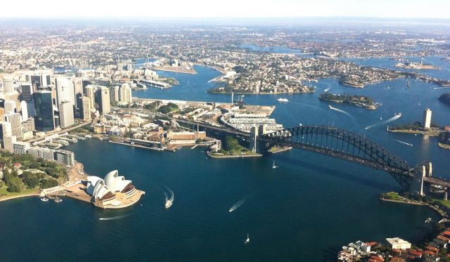
Where is it? Sydney Harbour, NSW
How to see it for yourself?
Some international flights still offer Harbour views as they fly out from Kingsford Smith, but gone are the days you’d see this on the way in. To get this view, take a seaplane flight with Sydney Seaplanes. A 15-minute Sydney Highlights charter starts at $185 per person, minimum of two adults. Flights depart from Rose Bay.
Why I love it
“As a Pom who lived in Oz as a young man, now approaching 60, this is a sight that rekindles my Australian love affair every time I fly into Sydney. It’s a view that surpasses Uluru or the Great Barrier Reef in its international recognition. It is simply stunning." – Kevin Allitt, AT reader
100 Best Views – 61 to 70
61. Ubirr Sunset, NT
Where is it? Kakadu National Park, NT
How to see it for yourself?
Drive 117km east of Darwin along the Arnhem Highway. From the Ubirr Arts Centre, walk 1km to view Indigenous rock art and access the lookout via signed paths.
Why I love it
“I’ll never forget my first sunset at Ubirr. I’d spent the afternoon enjoying the rock art, then made my way to the stone escarpment. It was beautiful looking out over the Nadab floodplain and surrounding stone country as the sun sank below the horizon. Wisps of bushfire smoke played with the pink and purple hues of the sunset." – Nelson Hall, Tourism NT
62. Avon Valley From The Air, WA
Where is it? 100km north-east of Perth
How to see it for yourself?
Windward Balloon Adventures start at Northam Airfield and fly over the west coast of Perth, Mount Ommaney, Mount Bakewell and the township of Northam.
Why I love it
“The countryside is a beautiful patchwork of colours. You feel utter peace as you float gently along. Pure enjoyment." – Heather Meiklem, Windward Balloon Adventures
63. Fern Pool, WA
Where is it? 1600km north of Perth, in Karijini National Park
How to see it for yourself?
Access to the National Park is via sealed Karijini Drive. Most roads inside the park are gravel, but 2WD accessible. Follow the signs to Fortescue Falls. From there, take the walking track into Dales Gorge and past Fortescue Falls then turn right to Fern Pool.
Why I love it
“Of all the beautiful places in WA, my favourite is walking through the Gorges of Karijini. Fern Pool has a very spiritual feel to it. It’s so peaceful to sit and listen to the water falling, and to see the wildlife that makes this place home. You have to get to this place." – Paul Welch, photographer
64. Kanangra Walls, NSW
Where is it? 180km west of Sydney, near Jenolan Caves
How to see it for yourself?
From Sydney, take the Great Western Highway to Jenolan Caves Road, on to Kanangra Walls Road. Although it’s unsealed, 2WDs can still get through.
Why I love it
“Kanangra Walls overlook the wildest scenery in the Blue Mountains. From here there is a threeday bushwalk to Katoomba via Coxs River and Narrow Neck Plateau, or a five-day walk to Mittagong." – Julian Ledger, photographer
65. Boranup Karri Forest, WA
Where is it? 25km south of Margaret River, Leeuwin-Naturaliste National Park
How to see it for yourself?
Take Caves Road through what is known as the S Bend, or Kodak Korner as locals call it. There is a viewing platform on the left which looks across the road and to the Boranup Karri Forest.
Why I love it
“It’s a great place to stop and think about what your ‘problems’, and realise these trees were here well before you and will be here long after you are gone." – Steven Powell, photographer
66. Point Lowly Lighthouse, SA
Where is it? 395km north of Adelaide, Port Bonython
How to see it for yourself?
Point Lowly Lighthouse is on a point jutting into the northern end of Spencer Gulf. Drive from Whyalla to Port Bonython, which takes about 20 minutes.
Why I love it
“I love to photograph this lighthouse because every shot has a different feeling depending on the time of day, as the light changes." – Jason Lloyd, photographer
Need tips, more detail or itinerary ideas tailored to you? Ask AT.
AI Prompt
67. Mount Wellington, TAS
Where is it? About 20km west of Hobart, Pinnacle Road, Wellington Park
How to see it for yourself?
Drive to the summit following Pinnacle Road. In winter, the road can close due to snow or ice cover so check beforehand. The lookout is a two-minute walk from the car park. Various tracks allow you to bushwalk, cycle or horse-ride.
Why I love it
“The view facing west is like a trip back to the time of dinosaurs. There is something eerie yet beautifully breathtaking. When the sun is setting on you and the wind is still you couldn’t feel more at peace." – Michael Walters
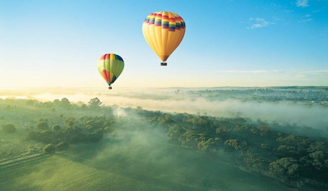
68. Yarra Valley, VIC

Where is it? 60km north-east of Melbourne
How to see it for yourself?
This view is from a hot-air balloon above Dixons Creek, looking towards Yarra Glen. De Bortoli Winery can be seen on the right. The balloons land as close to Rochford Wines as possible, so guests can enjoy a sparkling-wine breakfast.
Why I love it
“A dawn hot-air balloon ride over the Yarra Valley is something special." – Lincoln Wilson, Yarra Ranges Regional Marketing
69. Coffs Harbour Skydive, NSW
Where is it? 535km north of Sydney, 64 Aviation Drive, Coffs Harbour
How to see it for yourself?
Book a skydive with Coffs City Skydivers to see the central coast from above, while free-falling back towards earth. Mid-jump, enjoy views like this one, taking in views of over 200km of coastline and the Great Dividing Range.
Why I love it
“Breathtaking coastal views from above the Solitary Islands Marine park with the Great Dividing Range as a backdrop! I feel it shows the beauty of this area from our perspective, flying through the air with your friends!" – Lawrence Hill, Coffs City Skydives
70. Lost City, Cape Crawford, NT
Where is it? 106km south-west of Borroloola, Cape Crawford
How to see it for yourself?
Jump on a helicopter with Cape Crawford Tours at the air base opposite Heartbreak Hotel then fly to these ancient sandstone columns.
Why I love it
“Going from flat land to 25m-high natural skyscrapers is an experience you don’t expect. It feels like there’s a history here that we will never really know about." – Nelson Hall, Touris
100 Best Views – 71 to 80
71. Main Range Perisher, NSW
Where is it? In the NSW Snowy Mountains
How to see it for yourself?
This view of Main Range at Perisher was taken from the lookout behind the Blue Cow terminal building, looking south to Mount Townsend. The lookout is accessible on foot when guests get off the Skitube at Blue Cow.
Why I love it
“It’s such a scene of pure, untouched beauty it makes me want to dust off my skis." – Elisabeth Knowles, former editor, Australian Traveller
72. The Milky Way from Smitt Rock, NT
Where is it? 244km south-east of Darwin or 30km from Katherine, in Nitmiluk National Park
How to see it for yourself?
Gorge Road into the Park is all bitumen and ends at Nitmiluk National Park Visitor Centre, a great starting point for hiking. Take the 24km return walking trail that commences at the centre. Smitt Rock is in Gorge Four of the 13 sandstone gorges and you can camp overnight here.
Why I love it
“The NT outback is one of the best places in the world to see the night sky. With little light pollution, Australia’s Southern Cross and Milky Way are seen clearly. Grab a swag, get cosy and watch one of the best lightshows in the world." – Nelson Hall, Tourism NT
73. Kimberley Coastal Camp, WA

Where is it? 350km north-east of Derby, on the shores of Admiralty Gulf
How to see it for yourself?
The only one way to access this secluded hideaway is by light aircraft to Mitchell Plateau, followed by a helicopter transfer.
Why I love it
“I’ve been working at Kimberley Coastal Camp since 2005 and every time I fly in for the first time each season, I get a bit choked up by just how remote and special this magnificent place is. For me, this view is quite emotional." – Ebony Muirson, Kimberley Coastal Camp
74. Chapel Hill Winery, SA
Where is it? 42km south-east of Adelaide in McLaren Vale
How to see it for yourself?
This shot was taken from just outside Chapel Hill Retreat, overlooking the vineyards with Gulf St Vincent in the background.
Why I love it
“Gently undulating hills are bathed in sunshine and cooled by sea breezes. The vineyards border beautiful Onkaparinga National Park." – Damien J Smith, Chapel Hill Winery
75. Dicky Beach, QLD
Where is it? 93km north-east of Brisbane, in Caloundra
How to see it for yourself?
Drive five minutes north along the coastline from Caloundra. Dicky Beach is at the end of Beerburrum St.
Why I love it
“The wreck of MS Dicky, washed ashore more than 100 years ago, is an iron skeleton on the beach. The best time to have a look is just after sunset when the wreck shines red in the last daylight. An amazing spot!" – Hartmut Toepler, photographer
76. Pieman Heads, TAS
Where is it? 172km south-west of Smithton, Pieman Heads, Corinna
How to see it for yourself?
To reach Arthur-Pieman Conservation Coastline, drive west from Smithton along the Bass Hwy to Arthur River Rd then down Gardiner Point Rd. There are 4WD tours and walking trails here, as well as the Pieman River Cruise.
Why I love it
“It’s the longest uninterrupted expanse of ocean in the world. Absolutely breathtaking." – Diane Byrne, Tourism Tasmania
77. Gindjala (Goose Camp), NT
Where is it? 300km east of Darwin in Kakadu National Park, Gagudju Lodge Cooinda (near Yellow Waters)
How to see it for yourself?
See flocks of magpie geese taking off on a tour with Kakadu Animal Tracks Safaris, costing from $205 for adults and $135 for children. Safaris leave from Gagudju Lodge Cooinda.
Why I love it
“This is one of the largest annual bird gatherings in the world. The best bit is the deafening roar as the sky fills with tens of thousands of wetland birds evading a hungry crocodile, sea eagle or dingo. It is the sight that every Kakadu visitor hopes to see." – Rachael Arnold, Kakadu Animal Tracks Safari
78. Silverton, NSW

Where is it? 20km West of Broken Hill, on Silverton Road
How to see it for yourself?
To get to Silverton from Broken Hill, drive for about 20 minutes along Silverton Rd.
Why I love it
“The colour of the sand matches the colour of the rusting car, which is embedded in the most amazing landscape in the NSW outback. It’s a must-see!" – Hartmut Toepler
79. SkyPoint Climb, QLD
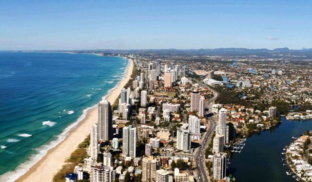
Where is it? Q1 Resort, Surfers Paradise
How to see it for yourself?
The SkyPoint observation deck of Q1 Resort can only be reached on the SkyPoint Climb, Australia’s highest external building walk. You take the lift to the 77th floor, then climb 300
external steps to the peak.
Why I love it
“It’s not just the view, but the feeling of accomplishment when you reach the summit." – Melinda Lloyd, Dreamworld
80. The Neck, Bruny Island, TAS
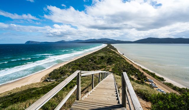
Where is it? About 40km south of Hobart, on Bruny Island
How to see it for yourself?
The Neck is a narrow isthmus separating north and south Bruny Island. It is 25km south of Roberts Point, where car ferries from Hobart dock. This shot was taken from Truganini Lookout – a timber stepped boardwalk that gives visitors spectacular panoramic views.
Why I love it
“This is one of my favourite places, where The Neck separates Adventure Bay on the left and Simpsons Bay to the right. This place bursts with native wildlife and has some of the best fishing spots!" – Diane Byrne, Tourism Tasmania
100 Best Views – 81 to 90
81. Bondi Beach from Icebergs, NSW
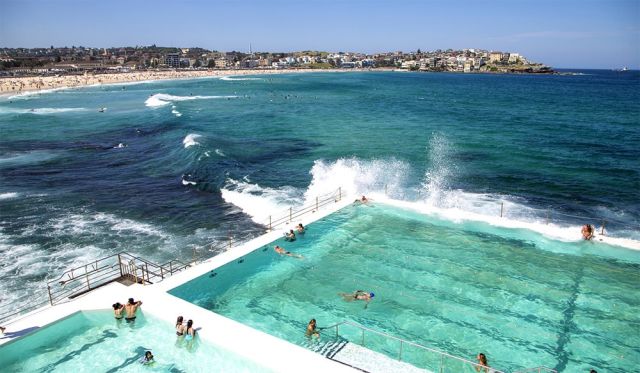
Where is it? 1 Notts Avenue, Bondi Beach, Sydney, NSW
How to see it for yourself?
This is Bondi Baths (part of the Bondi Icebergs Club complex).
The 50m ocean pool has been a local landmark for over 100 years, and there is now a smaller children’s pool nearby. To see the view firsthand and swim a few laps, sign in as a visitor at the Icebergs entrance, which costs $5.50 per adult. If you want to go to the restaurant or bar, you’ll need to live more than 5km away or be signed in by a member.
Why I love it
“It’s the quintessential Aussie ocean pool, which can also be viewed with a beer in hand from the club upstairs." – Elisabeth Knowles, former editor, Australian Traveller
82. Front Beach, Hopetoun, WA
Where is it? About 590km south-east of Perth, on Esplanade Road
How to see it for yourself?
Front Beach borders Fitzgerald River National Park. It’ll take about 7.5 hours to drive here from Perth or 45 minutes from Ravensthorpe, along the helpfully named Hopetoun-Ravensthorpe Rd.
Why I love it
“This image was captured after sunset, on the evening of an eclipse. It’s rare to capture such an occasion. I will always remember this moment." – Dene Bingham, photographer
83. Gold Coast Hinterland, QLD
Where is it? About 65km south of Brisbane
How to see it for yourself?
Hot Air Ballooning rides drift across the Kerry Valley. Tours leave from Beaudesert and Canungra and include a champagne breakfast at O’Reilly’s Grand Homestead and vineyard.
Why I love it
“Being in a balloon here is like you’re floating back in time, before there were highways and skyscrapers. You’ve gotta love the Gold Coast hinterland!" – Rachel Casey, Hot Air Ballooning Gold Coast
84. Grand Pacific Drive, NSW
Where is it? 60km south of Sydney, Sea Cliff Bridge on Lawrence Hargrave Drive
How to see it for yourself?
You can walk, drive or ride a bike over the 655m-long Sea Cliff Bridge, which is part of Australia’s Grand Pacific Drive (Lawrence Hargrave Drive makes up the stretch between Stanwell Park and Thirroul).
This particular shot was taken at Clifton, looking to Stanwell Tops.
Why I love it
“The magnificent structure is an engineering masterpiece, which provides a scenic link to the south coast." – Jillian Graham, photographer
85. Gym Beach, Formby Bay, SA
Where is it? 295km south-west of Adelaide on the tip of Yorke Peninsula
How to see it for yourself?
If you’re driving, the turn off to Gym Beach is about 10km from Marion Bay. The road down to the beach is unsealed and rough, so take care in a 2WD. Alternatively, hike 6km along the coast from Browns Beach.
Why I love it
“100 Carribie Farmstay is close to some of the most amazing and untouched beaches in the world. Surf, fish, bushwalk, or drink a nice bottle of wine as the sun goes down." – Damien J Smith, 100 Carribie Farmstay
86. Henley Beach, SA
Where is it? West of Adelaide city, overlooking Gulf St Vincent
How to see it for yourself?
At the northern end of the beach is Grange Jetty (pictured). The beach is just south of Henley Square -– a popular Adelaide dining spot.
Why I love it
“Sunsets are always different on one of Adelaide’s most beautiful beaches." – Ann Clarke
87. King’s Canyon, NT

Where is it? 320km south-west of Alice Springs, Watarrka National Park
How to see it for yourself?
The Kings Canyon Rim Walk takes hikers on a four-hour walk around 270m-high sandstone cliffs, with amazing viewing points. For less active visitors, there’s the shorter Kings Creek Walk at ground level. Or book a scenic flight through Kings Canyon Resort.
Why I love it
“The amazing formation and brilliant sandstone colours of Kings Canyon." – Joseph Boulos, Delaware North Australia Parks and Resorts
88. La Perouse, NSW
Where is it? 14km south of Sydney, Anzac Parade in La Perouse
How to see it for yourself?
If you stand on the shore to the left of where boats pull in, you can watch as the planes come in to land at Kingsford Smith Airport.
If you’re without a vehicle, Sydney bus route 394 departs from Circular Quay, and route 393 departs from Railway Square.
Why I love it
“My final sunset in Sydney was just glorious – such an amazing way to end a wonderful day of exploring, eating and socialising." – Chevy Morgan, photographer
89. Mt Warning from Clarrie Hall Dam, NSW
Where is it? 815km north of Sydney in the Tweed Valley
How to see it for yourself?
Drive south-west of Murwillumbah, pass through Uki and turn south onto Doon Doon Rd.
Why I love it
“Due to its proximity to Cape Byron, the easternmost point in NSW, the mountain catches the first rays of sunlight in the morning." – Kim MacDonald, The Legendary Pacific Coast
90. Mundi Mundi Plains, NSW
Where is it? 29km west of Broken Hill, 4km west of Silverton
How to see it for yourself?
Drive from Broken Hill along Silverton Rd, following signs to the Mundi Mundi Lookout.
Why I love it
“From here you can see more than 150km over a whole lot of nothing. Even the curvature of the earth can be seen. It’s an iconic place as parts of Priscilla, Queen of the Desert were filmed here." – Hartmut Toepler
100 Best Views – 91 to 100
91. Twin Falls, NT
Where is it? Kakadu National Park
How to see it for yourself?
In dry season, Twin Falls can be accessed by 4WD (preferably with a snorkel) down a signed track off the Kakadu Highway.
Day tours can be taken from Wildman Wilderness Lodge in the Mary River Wetlands. See the falls from the air any time of year with Skytours or Kakadu Air.
Why I love it
“See Jim Jim and Twin Falls at their thundering best during the wet season. Kakadu National Park comes alive during the wet and a bird’s eye view is the best way to witness the spectacular World Heritage-listed National Park." – Sally Cope, Wildman Wilderness Lodge
92. Wolfe Creek Crater, WA
Where is it? 1333km south-west of Darwin, on the edge of the great sandy desert, WA
How to see it for yourself?
In dry season the crater is 2WD accessible; however in the wet Halls Creek is the furthest you can go. 4WDs make it accessible year-round. Visitors can walk around the vast expanse of the crater, but there is no water supply so bring plenty with you. For an aerial view, Northwest Regional Airlines fly travellers over it from Halls Creek airport.
Why I love it
“Wolfe Creek Crater is thought to be the secondlargest meteorite crater in the world. The walls of the crater are up to 35 metres high and the crater floor is more than 50m below the rim – an amazing site from the ground or air." – Jo Durbridge, Australia’s North West Tourism
93. Blue Pearl Bay, QLD
Where is it? 25km north-east of shute harbour, on Hayman Island, Great Barrier Reef
How to see it for yourself?
Blue Pearl Bay is only accessible by a five-minute boat ride from Hayman Island Resort
Why I love it
“Blue Pearl Bay is one of the few places you can swim off the island to explore the Great Barrier Reef. The water is so clear that you can see colourful coral and tropical fish from the shore." – Lauren Esplin, Hayman Island Resort
94. Mt Buller Summit, VIC
Where is it? 248km north-east of Melbourne, on Mount Buller Road
How to see it for yourself?
Visitors can trudge from the top of the Summit Chairlift up a short but steep incline to reach the Fire Hut (pictured). The black-diamond ski runs that start here are not for the faint hearted.
Why I love it
“You feel on top of the world here. Incredible views show the surrounding High Country as far as Mt Hotham and Falls Creek." – Gillian Dobson, Mount Buller/Mount Stirling Resort Management
95. Murray River, SA

Where is it? Stretching inland from the ocean at Lake Alexandrina, 100km east of Adelaide
How to see it for yourself?
Take a cruise up the river on a paddleboat with Captain Cook Cruises. Its cruises extend from Blanchetown to Murray Bridge, and run for up to seven nights. This particular view was taken from Big Bend.
Why I love it
“This captures the Outback Australia I’d only read about. Towering limestone cliffs, picturesque gorges, riverbanks lined with mallee scrub, red gum forests and century-old stone causeways. Just beautiful!" – Brooke Tolar, Captain Cook Cruises
96. Stockton Beach Sand Dunes, NSW

Where is it? 200km north of Sydney, just above Newcastle
How to see it for yourself?
The sand dunes cover 32km and can be accessed on foot, horseback, quad-bike or 4WD. There are many local operators that offer services to enhance visitor experiences of the area, including Port Stephens 4WD Tours, Sahara Trails Horse Riding and Quad Bike King.
Why I love it
“When you look across these dunes you feel like you could be in Saudi Arabia! The southern hemisphere’s largest moving sand mass, the windswept patterns on the dunes and the hills are just awesome." – Kim MacDonald, The Legendary Pacific Coast
97. Bunda Cliffs, Head of Bight, SA
Where is it? About 280km west of Yalata, along the Great Australian Bight
How to see it for yourself?
Visitors can drive along the Eyre Highway with less than a kilometre between them and the cliffs. The cliffs extend over 85km, and there are five main lookouts, with signed access roads from the highway. The view here is taken from the lookout at the Head of Bight.
Why I love it
“You get to see in 3D that distinctive big chomp mark on maps of Australia. The Nullabor’s coastal cliffs are even more wild and raggedy than you’d expect. Between June and October it’s the perfect place to spot southern right whales." – Elisabeth Knowles, former editor, Australian Traveller
98. Captain Cook Highway, Tropical North Qld
Where is it? 70km between Cairns and Port Douglas
How to see it for yourself?
Starting in Cairns, drive along the Captain Cook Highway towards Port Douglas. It takes under an hour, giving plenty of time for stops along the way to enjoy the scenery. This particular view was taken about halfway along, at Rex Lookout.
Why I love it
“The road between Cairns and Port Douglas is as good as you’ll get anywhere in the world, with amazing views along the drive you can pull over and really take it in." – Dale Flack, Tourism Tropical North Queensland
99. The Nut, TAS
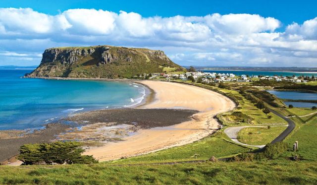
Where is it? 400km north-west of Hobart, in Stanley
How to see it for yourself
The Nut State Reserve is walking distance from the town’s CBD. There is a chairlift and a walking track to the summit of The Nut, which offers spectacular views across Stanley and the Bass Strait. However, the view pictured was taken from Highfield Historic Site, looking south-east.
Why I love it
“I love to sit high above the picturesque Stanley fishing village and experience remoteness and quietness while looking out at the uninterrupted views across Bass Strait." – Diane Byrne, Tourism Tasmania
100. Perry Sandhills, NSW
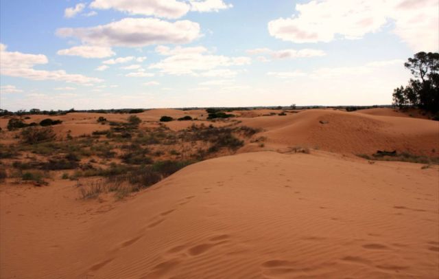
Where is it? Near the Victorian border, 6km west of Wentworth
How to see it for yourself There’s a car park on Old Renmark Rd.
Explore 400 acres of sand dunes solo or take a private tour, arranged through Wentworth Visitor Centre. Keep an eye out for the God Tree, a Murray River gum said to be over 500 years old with its trunk buried deep in the sand. It’s behind the car park shelter over the nearest sandhill.
Why I love it
“I love that you can feel so remote while being so close to a town. Take cardboard with you. It’s a hoot to slide down with the kids." – Glynn Jacobs, Outback NSW
100 Best Views – 1 to 10
1. Hardy Reef, QLD
Where is it? The reef is 60km out from Shute Harbour/Airlie Beach
How to see it for yourself?
Most of the Great Barrier Reef’s attractions lie under the surface, of course, and Hardy Reef in its southern section (further from shore and therefore less trafficked) is a great place to see them. Expect a stunning array of polychromatic hard and soft corals, a couple of hundred fish species – including tusk fish, trevally, snapper, cuttlefish, moray eels, barracuda, unicorn fish, surgeonfish, angelfish, wrasse, gropers – not to mention starfish, giant clams and even the occasional passing whale.
But you’ll have to take to the air to see this sight and the other major local attraction, Heart Reef, which is in a protected area off-limits to underwater tourists. Hardy Reef features Fantasea’s permanent Reefworld pontoon, where you can snorkel, dive, do a semi-submersible tour and even stay the night, while further out is Cruise Whitsundays’ Knuckle Reef pontoon. Both offer helicopter flights starting from $110/$129 for 10 minutes.
This image was taken from a chopper at midday. Those with deeper pockets can also fly out from the Whitsunday Islands or the mainland – by helicopter or seaplane – in 30 minutes to save themselves the long boat ride.
Why I love it
“Hardy Reef is probably my favourite part of the Great Barrier Reef, because it features beautiful turquoise colours and incredible textured patterns. This particular view holds significance to me because it was my first ever helicopter flight and aerial photo shoot." – Mark Gray
2. Burra Homestead, SA
Where is it? Just outside Burra, 160km north of Adelaide
How to see it for yourself?
Famous to Midnight Oil fans for featuring on the cover of Diesel and Dust – also shot by Ken Duncan – this old homestead at the foot of the Mt Lofty Ranges was abandoned long ago by smallholders unable to sustain a livelihood on this rain-starved land.
Ironically, this iconic scene of golden rural Australia is looking a lot greener now after all the recent rain – if you visit in September-October, you might even find it surrounded by canola in bloom, though the crops are rotated.
Hence you might not see this this exact scene. Drive north on the Barrier Highway for 6km from the centre of the historic town of Burra – once a major copper mining centre and also a location used in the filming of Breaker Morant. You’ll see the homestead on your right about 100m off the road. But bear in mind it’s on private property, so unless you ask permission for a closer look, you can only view it from the road. The building faces west so visit in the late afternoon to see it in its best light.
Why I love it
“I first immortalised this old farmhouse in my early days as a landscape photographer. The original shot became one of my most famous images when it was used on Diesel and Dust. How it tickled me when I returned to the area more than ten years later and the local tourist office gave me directions to ‘the Midnight Oil house’!" – Ken Duncan
3. The Twelve Apostles, VIC
Where is it? Near Princetown, 200km down the Great Ocean Road from Geelong, or 270km south-west of Melbourne
How to see it for yourself?
Constant erosion by wind and sea of the limestone cliffs formed caves and then bridges; when these collapsed – the fate of the nearby Island Archway in 2009 and London Bridge in 1990 – they left these stacks up to 45m high isolated offshore.
They’re a highlight of the Great Ocean Road – probably Australia’s most scenic coastal drive. Note that you can shave 50km off the drive from Melbourne by taking the inland route via the Princes Highway, but then you’d miss out on the other attractions. Formerly called the Sow and Piglets until being renamed the 12 Apostles in the 1920s, they have never numbered 12 – though it depends who’s counting.
Continuing erosion means they could topple at any time, but you can currently see seven stacks to the west of the 12 Apostles viewpoint, and two more to the east. Sunrise – the time this shot was taken – offers the most dramatic lighting from the viewpoint, followed by sunset.
And visit at dawn or hang around after the sun goes down to see little penguins – they come ashore each evening on the beach at the base of the 70m cliffs. If you want to get to the water’s edge yourself, the nearest access is via Gibsons Steps, 1km to the east, but access is restricted.
Why I love it
“People are not normally allowed onto this beach because of the penguin colony, but I was granted special permission and had to be accompanied by a ranger. We arrived in darkness to position ourselves for sunrise; at first light the penguins began to prepare to go out fishing.
First one of the birds came down to the water’s edge to make sure everything was OK, then he signalled to a little troupe of followers to join him. This was mirrored down the entire beach as hundreds and hundreds of penguins began their daily routine. Some of thepenguins actually walked within inches of my tripod. After they had all departed, the moon began to sink towards the horizon and its silvery light illuminated the scene before me." – Ken Duncan
4. Bungle Bungle Ranges, WA
Where is it? Purnululu National Park, WA, 250km south of Kununurra
How to see it for yourself?
You’ll be speechless within seconds of take-off as you’re introduced to Purnululu National Park’s Bungle Bungle Range, a carved 350 million-year-old landscape of gorges and pools surrounded by a soft, green blanket of grassland. Since its discovery in the 1980s, what was once Australia’s best-kept secret is now internationally recognised as a top destination. Because most of the area is inaccessible by car or foot, the best way to appreciate the tiger-striped beehive domes is from a plane or helicopter.
Why I love it
No matter how many times you soar over the Bungle Bungles, they always look different, depending on the time of year, the time of day and prevailing weather conditions. It’s a place you could visit time and again, and we urge you to do it at least once in your lifetime.
5. Hill Inlet, Whitsunday Island
Where is it? East coast of Whitsunday Island, the largest island in the group offshore from Airlie Beach, between Rockhampton and Mackay
How to see it for yourself?
Access to Whitsunday Island, one of the undeveloped islands in the group that forms the Whitsunday Islands National Park, is usually by boat from Airlie Beach/Shute Harbour or via one of the other island resorts, but there are helicopter/seaplane joy flights if you want to see it from the air like this.
The Whitsundays offer a range of accommodation options from camping to qualia, Hamilton Island’s luxury resort, but the perfect way to experience the islands, reefs and the swirling turquoise water and pure white sands of Hill Inlet is on your own yacht – look into skippered or bareboat hires.
You can anchor overnight at Tongue Bay (at the left of this picture), and walk up to a lookout at Tongue Point for a view over the inlet. Visit at low tide to see the best patterns. Whitehaven Beach stretches 7km south from Hill Inlet and is also worth pointing a camera at: it’s one of Australia’s most beautiful beaches, boasting sand of such purity you could make optical glass from it.
Why I love it
“Great swirls of pure white silica sand sweep and curl through crystal clear waters. The patterns, like those of a kaleidoscope, are everchanging; churned by a moving shaft of silica out to sea. This, to me, is one of the most beautiful locations on the planet." – Ken Duncan
6. Craig’s Hut, Mt Stirling, VIC
Where is it? In the Australian Alps, 230km north-west of Melbourne
How to see it for yourself?
Drive up towards Mt Buller from Mansfield, then take a left after the Mirimbah tollgate onto Stirling Road.
Then it’s 8km of sealed road to Telephone Box Junction, the limit for vehicles in winter. But in the warmer months you can continue to the gravel by 2WD Circuit Road: turn left and drive for 20km to the junction with Clear Hills Track. From there it’s a 20-minute walk or short 4WD drive to Craig’s Hut.
The spectacular, minimally developed Mt Stirling attracts cross-country skiers, horse riders and bushwalkers. The original Craig’s Hut, inspired by those used by cattle drovers for temporary shelter, was built for the movie The Man from Snowy River (1982) but burnt down in a bushfire.
This replica – with a tin rather than bark roof – was completed in 2008. The shot was taken at sunrise. There are a couple of hundred huts (or their ruins) scattered through the Australian Alps; some built for fishermen, skiers, miners or hydro workers as well as graziers. Most are only accessible on foot/bike/horseback. Wallace Hut near Falls Creek (see number 26 in this list) is thought to be the oldest, built in 1889. A further 2km down the Bogong High Plains Road is Cope Hut, built for skiers in 1929, while Fry’s Hut in the Howqua Hills Historic Area, 34km from Mansfield, is another good example. See the sites below for more information.
Why I love it
“I spent three days camping in the snow at Craig’s Hut with a good friend a few years ago and it was an experience we will never forget. The peace and solitude were incredibly unique. We drank ice-cold water from a nearby stream and built a campfire from fallen tree branches.
Every night we lay awake in our tents trying to figure out what kind of high-country animals made such terrifying noises! Perhaps the rumours of wild cats and panthers have some credibility after all." – Mark Gray
7. Remarkable Rocks, Kangaroo Island, SA
Where is it? Kangaroo Island, which lies 15km off South Australia’s Fleurieu Peninsula
How to see it for yourself?
KI has plenty of natural attractions (see issue #36) – beaches, wildlife, seafood, sheer peace – but these rock formations in Flinders Chase National Park, in the south-western corner of the 150km-long island, are a big draw.
The granite boulders, decorated with orange lichen, sit atop a bald rock outcrop that slopes down into the sea, and have been sculpted with tafoni (deep cavities) – by wind, rain and sea spray. The classic shot of the rocks is taken facing north, but this group is to the south-west. You can get to KI by car ferry or plane.
Why I love it
“The balance of the formation really fascinated me; I was especially taken with the ‘open arms’ of the larger stone at the front right of the group. It was as if it was protecting the little rock beneath it, like the enshrouding wings of an angel." – Ken Duncan
8. Cradle Mountain, TAS
Where is it? Cradle Mountain-Mt Field NP, 90km south of Devonport
How to see it for yourself?
From Dove Lake car park, it’s a two-and-a-halfhour return walk up to Marions Lookout for good views of Cradle Mountain.
Why I love it
“It was a beautiful winter’s day. After getting some shots at the base of Cradle Mountain, I headed back, but after walking for half an hour I decided it wasn’t the right way. I backtracked and looked up to see a full moon rising. I quickly set up my tripod to capture this amazing sight.
I was thinking how fortunate I was that I had taken the wrong track… and then the guide markers disappeared under snow and I became hopelessly lost. I’d started the walk to Marions Lookout at 1pm; it was now 9pm and I was buggered. I sank to my knees and yelled, ‘Help!’ “To my amazement, a male voice replied, ‘Are you right, mate?’ He told me to walk towards his torch. “He introduced himself as Wes Moule and he was going moonlight skiing.
He insisted he guide me back over the next 200m as it was very icy. He said he carried 45kg packs to the walkers doing the Overland Track in summer. I googled Wes later and found he was in remission from cancer, and had vowed that for every kilometre walked carrying the packs he would donate $1 to the W. P. Holman Clinic in Launceston. Wes walked 1220km in 2010-11, and 1170km in 2011-12. I finally made it back to the car park at 10.30pm. The car was frozen over and the road was iced up but I made it home. Then came the hard part: explaining why I was late to my wife!" – Jeff Crow
9. Parachilna Gorge, Flinders Ranges, SA
Where is it? East of Parachilna, 200km north of Port Augusta Outside the Flinders Ranges National Park
How to see it for yourself?
Reach this scenic outback gorge by turning right at Parachilna (if approaching from the south) towards Blinman. It’s a dirt road and OK for 2WDs unless it’s been raining and the creeks are flowing. You can camp anywhere in the gorge for free at any time of year, but it’s best seen in spring.
This region is great for 4WDs, with a network of Public Access Routes allowing you to traverse private land – download a map and always check road conditions. Parachilna itself is home to not much beyond the Prairie Hotel, famous for its Flinders Feral Food using local ingredients.
Why I love it
“This is a photo that had existed for years in my mind before it became a reality. Travelling along this road, we were caught in the dust of another car when suddenly I saw the possibilities, so we stopped and set up the camera. I asked my assistant to get back into the vehicle and drive by nice and fast. Much to his delight we had to do it again and again before the dust, the light and the wind came together." – Ken Duncan
10. Cathedral Rocks, Kiama
Where is it? Jones Beach, 3km north of Kiama
How to see it for yourself?
Kiama is only 120km south of Sydney and an easy daytrip through the Royal National Park and down the pretty South Coast, but there’s plenty to see in the area to warrant a longer stay. Most visitors are drawn to Kiama’s famous blowhole, another product of the ancient volcanic lava flows that also formed Cathedral Rocks. You’ll find them at the southern end of Jones Beach, and with a little bit of early morning rockhopping you’ll be able to see them from this angle. By the way, don’t confuse this formation with Cathedral Rock in northern NSW.
Why I love it
“Luring sightseers since 1890, the atmosphere at Cathedral Rocks is something else. You get a real beginning-of-time feeling when visiting." – Kieran O’Connor
100 Best Views – 11 to 20
11. West Island, Cocos (Keeling) Islands
Where is it? The Cocos (Keeling) Islands lie 2750km north-west of Perth in the Indian Ocean
How to see it for yourself?
Virgin Australia flies to the Cocos (Keeling) Islands from Perth via Christmas Island. Comprising the South Keeling Islands (which ring a central lagoon) and the separate North Keeling Island, only two of the 27 islands are inhabited.
These coral atolls were visited by Charles Darwin in 1836 and his studies here contributed to his theory on how coral reefs form. The islands were settled for copra production in 1826 and the small population is descended from the original, mostly Malay Muslim workers.
They voted to become part of Australia in 1984. A quintessential tropical paradise, you come here to dive, snorkel, camp, surf, kite-surf, birdwatch and chill out, not party.
Why I love it
“The image is taken from the south end of West Island looking over the lagoon. Sometimes the water is glassed off, sometimes it’s littered with colourful kite-surfing sails, and sometimes it has the most magical sunsets and moon rises! All together on a beautiful and remote tropical island." – Jules Bush, Cocos Keeling Islands Visitor Centre
12. Norah Head Lighthouse, NSW
Where is it? About 115km north of Sydney on the state’s Central Coast, the lighthouse can be found at 40 Bush St, Norah Head
How to see it for yourself?
This shot was captured from the north end of Soliders Beach, looking up to the lighthouse, which can be seen in the distance to the left. There are also amazing views from the lighthouse itself. Visitors can have a guided tour around it or even spend the night there, in nearby cottages that were once the lighthouse keeper’s quarters.
Why I love it
“I love the emotion of this scene: the contrast of lights and darks, the newly risen sun in the clouds, the crash of the surf and the shape of the rocks. In the distance stands Norah Head Lighthouse, one of the most recognisable features of the NSW Central Coast. Here its beam farewells the final shadows of night, yet how feeble it appears compared to the glory of the sun." – Ken Duncan
13. Piccaninny Creek, WA
Where is it? Near the NT border 300km south of Kununurra, the creek cuts through Purnululu National Park, past the Bungle Bungles
How to see it for yourself?
This picture was captured at the end of Piccaninny Gorge, which visitors can access on a hike of two to seven days via spinifex-covered grasslands and a lookout over the domes. Walkers must be fully prepared as they’ll encounter fallen boulders and loose rocks, and there is no reliable drinking water along the way. Register at the visitor centre for more info.
Why I love it
“As the sun rises, the awe-inspiring domes of the Bungle Bungles massif are reflected with unwavering precision in the waters of a pool at the end of Piccaninny Gorge. Weathered over millennia into amazing formations of bandedstone, the domes rise like a stupendous city in the remote north-east of WA. This pool, photographed at the end of the wet season, is likely to last only a month or so before the heat dries it to bare rock. But in the meantime, it awaits the dawning of a new day, adding tranquillity to the harsh world it so delicately mirrors." – Ken Duncan
14. Mitchell Falls, WA
Where is it? In the state’s far north, on the western side of the Kimberley, about 15 hours’ drive west of Kununurra
How to see it for yourself?
Mitchell Plateau is accessible by car during thedry season via an unsealed 4WD track off the Gibb River Road, along Kulumburu Road. Continue along it, turning at the Mitchell Plateau Track and drive on to the Mitchell Falls campsite.
It is a 3km walk from the campground to the falls, passing a variety of habitats, waterholes and Aboriginal rock art. To get another perspective of the Mitchell Falls, flight tours of the plateau are available with operators such as Bush Flight and Slingair Heliwork.
Why I love it
“While camping at Mitchell Falls we were surrounded throughout the night by fires lit by National Park authorities to aid the germination of bush seed. This form of environmental care has been practised by Aborigines for millennia. As smoke tempered the early morning light with lovely evenness, the colours of rock and water began to glow. Now as I recall this unrepeatable moment, I think of a line from an old song by The Eagles – ‘call some place paradise, kiss it goodbye’ – and I pray for the preservation of such unique wilderness." – Ken Duncan
15. Mossman Gorge, QLD
Where is it? In the southern section of the World Heritage-Listed Daintree National Park, about 20km west of Port Douglas in tropical north Queensland
How to see it for yourself?
This image was taken from the base of steps down to the waterhole at Mossman Gorge. The the best way to see this view first-hand is on fivefoot. Guided walks are available, which encompass other sites that are culturally significant to the local Kuku Yalanji people.
The vivid green of the water pictured tends to happen after extended periods without rain. According to the photographer, for ultimate serenity, the best time to visit is early in the morning before the crowds set in.
Why I love it
“Towards the end of the dry season the rapids of Mossman Gorge have usually disappeared. By then, the calm waters offer a perfect place to take a dip and escape the heat of Tropical North Queensland. I really love this view because the shades of green in the water and surrounding rainforest are truly remarkable." – Mark Gray
16. Ormiston Gorge, NT
Where is it? Off Namatjira Drive, 135km west of Alice Springs in West MacDonnell National Park
How to see it for yourself?
This shot of Ormiston Gorge was taken from the banks of the creek, a very short walk from the car park. The visitor centre is about 8km from the Ormiston Gorge turn-off on Namatjira Drive, and although roads are sealed, they can become impassable after heavy rain.
However, the best way to see the gorge is to walk one of the many trails available, ranging from the five minute Waterhole Walk, which has wheelchair access to the end of the paved path, to the Ormiston Pound Walk, which takes up to four hours to complete. For keen hikers, the Larapinta Trail also passes through the area, but it is a challenging long-distance walk that requires careful preparation.
Why I love it
“This is classic Australian outback country. People often think of the centre of Australia as arid, but in the desert there are some beautiful oases and this is one of those places. Where there is water, there is life, as evidenced by these graceful old river gums surrounding the waterhole. The creek is fed by spring water, and really only runs after heavy rain. The rich red walls rising up around the creek turn the gorge into a sanctuary – a beautiful place to go for a swim and find relief from the heat." – Ken Duncan
17. Cape Hauy, TAS
Where is it? Tasman Peninsula, 95km south-east of Hobart
How to see it for yourself?
This view is at the end of the cape, which has a detached sea stack known as the Candlestick. These dolerite seacliffs are among the tallest and oldest in Australia. Kayaking is available with operators such as Roaring 40s Ocean Kayaking. To see it from the land, the Cape Hauy Track is a five-hour return trek that begins in Fortescue Bay, taking in heath and woodland before the views of the cliffs.
Why I love it
“This breathtaking view gives me a genuine feel for untouched wilderness. Even better is the experience of walking along the track through a variety of health and woodland that reaches the magnificent views of steep cliffs and rock formations. The spectacular columns and cliffs surrounded by pristine waters are incredible." – Diane Byrne, Tourism Tasmania
18. Mt Feathertop from Mt Hotham, VIC
Where is it? In the heart of the Australian Alps National Park, 385km north-east of Melbourne
How to see it for yourself?
You can drive to Hotham, at the crest of the Great Alpine Road – the highest bitumen road in Australia. There are also several coaches that service the area, such as Christian’s Bus Co and O’Connell’s Omeo Bus Service. Otherwise, Hotham’s airport is serviced by QantasLink from Sydney in peak season – the flight takes 80 minutes – and charter flights from across Australia year round, and is a handy 20km from the slopes.
But while snow-based activities are popular during the winter months, in summer the landscape transforms into grassy mountain ranges speckled in wildflowers. Various tracks and trails thread through them, ideal for hiking, biking and horse riding.
Why I love it
“This is one of the most stunning views I have ever seen. To me, this view looking out onto Mt Feathertop is perfect no matter what time of day or year. Whether it is covered in snow or surrounded by blue skies, it can be admired and enjoyed all the time. The sunset here will take your breath away. Views like this make working at Hotham worthwhile." – Ruth Appleyard, Mt Hotham Skiing
19. Tantabiddi Sanctuary Zone, WA
Where is it? The centre of Ningaloo Reef, which skirts Cape Range Peninsula, west of exmouth and 1265km north of Perth
How to see it for yourself?
This is a shot of the Reefviewer glass-bottomed boat in the centre of the sanctuary. Tantabiddi covers only four square kilometres but is home to a wealth of marine life such as green sea turtles, estuary cod, parrotfish and clownfish. Ningaloo Ecology Cruises offers boat and snorkelling tours in the sanctuary, while Birds Eye View offers microlight flights for great aerial views like this.
Why I love it
This is my office! The beauty of World Heritage listed Ningaloo Reef never ceases to amaze me. With many years on the job as a captain of the boat pictured, this image made me realise again how lucky I am. Observing people’s excitement especially kids – is priceless. It stresses the responsibility to pass it on to my children in its stunning untouched state." – Alek Nowak, Ningaloo Ecology Cruises
20. Cook’s Look, Lizard Island, QLD
Where is it? Australia’s northernmost island, a 1 hour flight of Cairns.
How to see it for yourself?
After taking the flight to Lizard Island from Cairns, Cook’s Look can be accessed via a 4 kilometer steep hike to the vantage point. There, panoramic views of the island can be enjoyed, in between snorkels of the Great Barrier Reef of course.
Why I love it
“To call Lizard Island paradise feels like a gross understatement. Rocky outcrops of granite. Dry, sparsely vegetated hills. A pleasing barrenness tumbling down to coral-white beaches and aquamarine waters, this lookout encompasses the best of this dry island, which in many ways is reminiscent of the Greek islands in the Aegean Sea" – Eliza Sholly, Deputy Digital Editor of Australian Traveller
100 Best Views – 21 to 30
21. Finke River Lookout, NT
Where is it? Near Glen Helen Resort, 130km west of Alice Springs on Namatjira Drive
How to see it for yourself?
The ancient, 600km Finke River rarely flows and is often just a series of waterholes. There’s a permanent one in the gorge at Glen Helen in West MacDonnell National Park, which is also one of the few points where you can access the river by sealed road. Glen Helen Resort has motel-style accommodation and camping.
Why I love it
“This scene – typical of the country that inspired Albert Namatjira – was shot near Glen Helen. It was one of those rare occasions when the Finke River was flowing here. I had already packed up for the day when, suddenly, I saw the sky beginning to colour beautifully. I raced back out just in time to shoot this spectacular view." – Ken Duncan
22. Bicheno, TAS
Where is it? On Tasmania’s East Coast above Wineglass Bay, 180km north-east of Hobart.
How to see it for yourself?
This photo is taken directly in front of Diamond Island Resort, at 69 Tasman Highway, about 2km north of central Bicheno, looking north up the coastline.
Why I love it
“The feeling I get from sitting on a rock and taking in the views of this magical sheltered bay is something special. Its natural beauty and spectacular landscape offer the most peaceful setting where I can totally relax, reflect and think positive thoughts about the wonderful life I lead." – Diane Byrne, Tourism Tasmania
23. Hamersley Dunes, WA
Where is it? In The Fitzgerald River National Park, 550km south-east of Perth between Albany and Esperance
How to see it for yourself?
Fitzgerald River National Park contains more than 1800 plant species, 62 unique to the park, and more animal species than any other park in Australia. There are entry points on both sides: from the western side via Bremer Bay, or the eastern side via Hopetoun. The central area of the park, however, is only accessible by 4WD or on foot.
Why I love it
“Fitzgerald River National Park has incredibly diverse scenery. The Hamersley Dunes are just like a white-sand Sahara. There’s 4WD access and great fishing here, but the best catches are often what you capture through the lens." – Elisabeth Knowles, editor, Australian Traveller
24. Uluru, NT
Where is it? Off the Lasseter Highway, 450km south-west of Alice Springs
How to see it for yourself?
The easiest way to see this sacred monolith is to fly direct to Ayers Rock Airport (Yulara), which is about 22km north of Uluru. Alternatively you can drive or catch a tour bus from Alice Springs with an operator like Travel Aust (travelaust.com.au), which offers daily transfers.
Why I love it
“Indigenous Australians believe Uluru to be the centre of all Dreaming. Traditionally, this area was seen as something like the hub of a wheel, with songlines radiating from it across the land. I believe Uluru is a place that is special for all Australians. I would even go so far as to say that I believe a new ‘song’ is coming – a song of unity and reconciliation between the different cultures of our nation – that will spread powerfully through the rest of the land." – Ken Duncan
25. The Pinnacles, WA
Where is it? Nambung National Park, 230km north of Perth
How to see it for yourself?
Vehicles can access Nambung National Park from the north via Cervantes, or from Perth on the scenic Indian Ocean Drive. Access to the Pinnacles area itself is via a 1.2km marked walk trail or a 4km drive through the park. Visit the Pinnacles Lookout for a more elevated view.
Why I love it
“Regarded as one of Australia’s most unique landscapes, the Pinnacles Desert features thousands of golden limestone spires rising eerily out of the sand. You can get up close to the Pinnacles, some of which are several metres high, on a scenic drive or walk." – Grace Pappelendam, Australia’s Coral Coast
26. Wallace Hut, VIC
Where is it? Near Falls Creek, 375km north-east of Melbourne
How to see it for yourself?
By car, follow Bogong High Plains Road from Falls Creek towards Omeo – the road is sealed but closes during the winter season, so be prepared. Follow the road for about 7.5km and park at the signposted entrance. From there it is an easy 750m walk to the hut.
Why I love it
“This photograph celebrates an era of legends, when cattlemen roamed the high country of Australia’s southern range. This hut was one of the men’s old ramshackle resting places. It is captured here in the first light of morning between the spreading snow gums, a scene both of beauty and nostalgia.
The good sense of those days is highlighted by the horrendous fires which now so often threaten these protected places. The cattle which once kept the undergrowth in check are gone. Many people (myself included) believe they should now be allowed back." – Ken Duncan
27. Carisbrooke Station, QLD
Where is it? Off Cork Mail Road, 85km south-west of Winton, 970km west of Rockhampton
How to see it for yourself?
From Winton, follow Kennedy Development Road in the direction on Boulia, then turn left at Cork Mail Road for 45km and the entrance to Carisbrooke Station is on the left. The station also has a 1100m airstrip, with light aircraft flying to Winton. This view was taken from the top of an escarpment that runs parallel to Jundah Road, bordering the back of the property, looking back towards the station. The escarpment reaches 80m in places, giving great views area. It can be accessed by car from Carisbrooke, but it can be limited during the wet season.
Why I love it
“The colours are breathtaking; reds, ochres, whites and shades of green, topped by the clearest of blue skies. During the wet everything is saturated, so the colours seem to “pop" so much more. One can easily find a spot to sit all day to contemplate life and marvel at the beauty of this time-sculpted, ancient landscape." – Ziggy Ziegler, The Resort
28. Lake Oberon, TAS
Where is it? The Western Arthur Range, 90km south-west of Hobart in SouthWest National Park
How to see it for yourself?
This picture was taken looking north-west in the 15km-long, 22-peak Western Arthurs, south of Lake Pedder in the Tasmanian Wilderness World Heritage Area. You access the range from Scotts Peak Dam on a challenging walk of two to three days, or longer to traverse the whole range. Tasmanian Wilderness Experiences offers guided walks through the Western Arthurs.
Why I love it
“I love the breathtaking scenery in this magical part of the Tasmanian wilderness. I can easily spend time watching the wildlife, admiring the scenery and taking a few leisurely walks along the way. This is truly a special place that I can never remove from my mind." – Diane Byrne, Tourism Tasmania
29. Bay of Fires, TAS
Where is it? On Tasmania’s north-east coast, 275km north of Hobart How to see it for yourself
How to see it for yourself?
From St Helens (where you should buy food and fuel if camping), take Binalong Bay Road to the signposted turn-off to The Gardens, a hamlet at the northern end of the Bay of Fires Conservation Area. This is a 13km stretch of coast down to Binalong Bay that forms the southern section of the Bay of Fires.
Why I love it
“The landscape is so wild and beautiful. Red lichen-covered rocks contrast brilliantly with white sand and turquoise water, and there is so much animal and bird life. If you want a total change from the city, this is the place I’d recommend." – Elisabeth Knowles, editor, Australian Traveller
30. Devils Marbles, NT
Where is it? Just off the Stuart Highway, near Davenport, 395km north of Alice Springs and 760km south of Katherine
How to see it for yourself?
Known as Karlu Karlu and a sacred site to the traditional Aborginal owners, the Devils Marbles can be explored on foot after a short drive off the highway. There is a 15-minute self-guided walk commencing at the car park, as well as a network of other tracks. During the cooler months, guided walks and talks are available – contact the Tennant Creek Visitor Information Centre for details.
Why I love it
“As a strange collection of boulders strewn across a spinifex valley in imposing, sometimes impossible positions, the Devils Marbles is unlike anything else. Made of granite and rounded by erosion, its official name implies a diabolical origin – as if the devil had thrown them down with mischievous carelessness. I prefer to think of them as the handiwork of a Creator who does nothing haphazardly." – Ken Duncan
100 Best Views – 31 to 40
31. The Great Ocean Walk/Cycle Way, WA
Where is it? Esperance, 730km south-east of Perth
How to see it for yourself?
The 15km walking and bike trail commences at Castletown Quay and follows the foreshore through Esperance, taking in the Esplanade, Rotary Lookout, West Beach and Blue Haven and finishing at Twilight Beach.
Sections can be accessed from car parks along its length. This view is from the car park at Salmon Beach, about 11km along the trail. There’s a 40km Great Ocean Drive, too, from the Cannery Art Centre along the coast to Observatory Point, Nine Mile beach and Ten Mile Lagoon before looping inland to Pink Lake and the Glass Gallery.
Why I love it
“The path is very popular with tourists and locals. The beaches around here are used regularly for swimming; the walk trail is great for cycling and is also used for triathlons." – Tahnee Adamson, Esperance Visitor Centre
32. Overland Track, TAS
Where is it? Tasmania’s central north wilderness, From Cradle Mountain in the north to Lake St Clair to the south
How to see it for yourself?
This spectacular 65km, six-day walk is very popular and must be booked in the summer peak, November 1 to April 30, when you can only walk north to south.
Private cars can be parked at both Cradle Mountain and Lake St Clair ends. Otherwise bus operators such as Tassielink and McDermotts Coaches, service both ends from major towns. This particular shot was taken from the summit of Cradle Mountain itself.
Why I love it
“Nothing compares to the uniqueness of this view – the glacier-carved landscape decorated with tannin-stained lakes, the soaring peaks, and the plunging gorges. It’s amazing to see the stark alpine plains and hear the silent green rainforests. The range of plant species – including the fagus, one of Australia’s few native cold-living deciduous trees – is another remarkable feature of this region." – Diane Byrne, Tourism Tasmania
33. The Daintree from Myall Beach, QLD
Where is it? Cape Tribulation, 120km north of Cairns
How to see it for yourself?
Just opposite Cape Tribulation Camping, Lot 11 on Cape Tribulation Road, is the Dubuji Boardwalk. The boardwalk leads directly to Myall Beach where this view can be seen when looking south. This pristine beach has a fringing coral reef that’s exposed at low tide: a great place to explore the rockpools.
Inviting as it looks, you can’t swim here in summer stinger season. It’s also one of the many Tropical North Queensland beaches where the Daintree rainforest fringespristine white sand.
Why I love it
“Cape Tribulation is where the rainforest meets the reef." – Dale Flack, Tourism Tropical North Queensland
Weekly travel news, experiences
insider tips, offers, and more.
34. Christmas trees at Cape Le Grand National Park, WA
Where is it? On WA’s south coast, 50km east of Esperance
How to see it for yourself?
The WA Christmas tree, Nuytsia floribunda, produces spectacular flowers in summer but is rarely found outside the south of the state. Visitors can self-drive to the park by car and see the park’s wildflowers, fauna and idyllic beaches, but for local knowledge and expert advice, try a guided tour such as with Esperance Eco- Discovery Tours.
Alternatively, Aussie Bight Expeditions runs wildflower tours during spring.
Why I love it?
“Native Christmas trees are so vibrantly coloured, and when you pair them with clusters of tuftyheaded grass trees, the landscape takes on the aspect of a Pixar-created prehistoric world." – Elisabeth Knowles, editor, Australian Traveller.
35. Deep Water Point, WA
Where is it? Overlooking the Canning River in Mount Pleasant, 10km south of Perth’s CBD
How to see it for yourself?
This shot was captured at sunrise from the sand right next to Deep Water Point Jetty. Get there at least 20 minutes before sunrise to see the colour changes in the sky.
Why I love it
“Deepwater Point is my favourite location to visit in Perth, especially at sunrise. The jetty is a unique structure and points directly at the city, making for great photographs." – Mark Gray
36. Lake Ballard, WA
Where is it? 51km west of Menzies, 680km north-east of Perth
How to see it for yourself?
Follow the Goldfields Highway from Kalgoorlie to Menzies before turning left at a well-signposted service station onto a gravel road heading northwest.Continue a further 50km to the sign posted turn to Lake Ballard car park. From there, visitors can walk throughout the 10-square-kilometre salt lake, featuring the Inside Australia exhibit by Antony Gormley.
There are 51 sculptures in total, said to represent local members of the community. This shot was taken near the visitor entrance and shows Snake Hill in the background, about 600m from the lake edge.
Why I love it
“When you get there you realise it isn’t just the sculptures that you are viewing – the whole setting is an artscape. As you walk from one sculpture to the next you leave footprints on the salt, which is part of the artwork; man connected to man, connected to the environment. This is a magnificent art site in a magnificent location." – Jac Eerbeek, Australia’s Golden Outback
37. Eagle Falls, WA
Where is it? On the Drysdale River in The Kimberley, WA
How to see it for yourself?
The only way travellers can access Eagle Falls is via a helicopter flight with North Star Cruises, aboard the expedition ship True North. It offers a number of scenic flights around the area, including a five-star picnic package onsite.
Why I love it
“This view perfectly shows the epic landing area for the helicopter and how close the falls are to where we land. It is sometimes hard to get a feeling of scale with such shots. The river was flowing especially well on this occasion so it was spectacular. You can also see how excited the passengers are to be there." – Mark Stothard, True North director
38. El Questro Homestead, WA
Where is it? Coolibah Drive near Kununurra, in The Kimberley, 830km south-west of Darwin
How to see it for yourself?
This stunning view was taken on board an El Questro scenic flight. The experience takes visitors above the homestead in an open-door helicopter ride, over the Cockburn Ranges andthrough the Pentecost and (pictured) Chamberlain Gorges. A 30-minute scenic tour starts at $280 per person.
Why I love it
“The amazing contrast of the Chamberlain River with the rugged landscape of the Cockburn Ranges in the background – simply breathtaking." – Joseph Boulos, Delaware North Australia Parks and Resorts
39. Genoa Peak, VIC
Where is it? Croajingolong National Park, Gippsland, 500km north-east of Melbourne
How to see it for yourself?
Turn off the Princes Highway at Genoa Peak Road, west of Genoa. Travel 8km to the car park and picnic area. From there, take a 1.5km return walk to the summit (allow an hour each way). A steel ladder gives access to the viewing platform.
“Croajingolong National Park is a UNESCO World Biosphere Reserve, which means there is an effort to preserve the landscape in such a way that people can discover it and enjoy it without destroying it. Standing at Genoa Peak is a supremely peaceful experience." – Elisabeth Knowles, former editor, Australian Traveller
40. Gunlom Falls top pool, NT
Where is it? Waterfall Creek in Kakadu National Park, 315km south-east of Darwin
How to see it for yourself?
Gunlom Falls are accessible by 4WD vehicles along the Gunlom Track, near the southern entrance to Kakadu National Park. Drive carefully as the track is unsealed, subject to flooding and sandy in areas. It is impassable in the wet season but open between May and October. Once there, visitors can swim at the base of the falls or take the walking track to the top where there are more swimming holes – and where this view was taken. The walking track is steep, uneven and suitable for people with a medium level of fitness. Remember to take plenty of water for the trek.
Why I love it
“It’s the magical combination of a waterfall and serene plunge pool, with shady gums cooling the picnic areas. A steep climb to the top of the waterfall provides sweeping views of the southernmost parts of Kakadu National Park while you enjoy a relaxing dip in the crystal-clear pools." – Nelson Hall, Tourism NT
100 Best Views – 41 to 50
41. Horse Muster, Glenworth Valley, NSW
Where is it? Central Coast Hinterland, 65km north-west of Sydney, at Glenworth Valley Horse Riding, 69 Cooks Road, Peats Ridge
How to see it for yourself?
This view is taken at the Popran Creek crossing, in front of the main horse riding complex at Glenworth Valley. However, the best way for visitors to see the running in of the horses each morning is to camp the night so you are there in time. The paddocks the horses are kept in overnight are regularly rotated, meaning their route can vary. Check with staff for information on the safest location to view them.
Why I love it
“The daily mustering of the property’s 200 horses is a sight to behold. The ground shakes as the horses run through the morning fog and splash through the waters of Popran Creek and up the bank towards the yards, ready for a day of transporting guests along 50km ofprivate riding trails. It’s a ritual that has been done here for over 40 years." – Nicole Hain, Glenworth Valley Outdoor Adventures
42. Merimbula Lake, NSW
Where is it? Bordering the southern edge of merimbula on the South Coast, 450km south of Sydney
How to see it for yourself?
The view pictured was taken at sunrise while standing on the banks of the fishpen, located on the southern side of the bottom lake.
Why I love it
“In today’s world it is rare to find old, run-down jetties. They are usually quickly replaced with brand-new structures to avoid public liability issues. Merimbula Lake is one of the last few locations remaining in Australia that feature a variety of these old jetties. This makes it a photographer’s paradise, particularly during sunrise and sunset. I have spent countless hours at Merimbula Lake and have witnessed some incredible lightshows. This amazing sunrise occurred immediately after a rainstorm." – Mark Gray
43. Rangoon Island, NSW
Where is it? Just offshore from Minnamurra on the South Coast, 115km south of Sydney
How to see it for yourself?
Follow the Princes Highway south from Sydney towards Kiama before taking the Riverside Drive exit and following signs to Rangoon Reserve. With the Minnamurra River dividing the township from the ocean, visitors can access the beach closest to the island by boat. Otherwise, at the ar end of the beach is a car park with a rough walking track down to the sand. It is at this far end with many rocks that this view was taken.
Why I love it
“Shot at sunrise, Rangoon Island rises out of the water with a certain mystery surrounding it; I always feel a certain sense of peace when visiting it." – Kieran O’Connor
Image by Kieran O’Connor
44. Sir John Range, WA
Where is it? Mornington Wildlife Sanctuary, 550km north-east of Broome
How to see it for yourself?
At 3207 square kilometres, Mornington Wildlife Sanctuary is one of the largest non-government protected areas in Australia. The Mornington Wilderness Camp has ten safari-style tents and is open to visitors from May to October. It is accessible by 4WD or private air charter only. By 4WD, follow the Gibb River Rd 330km from Derby. Turn off at Mt House and continue south for 88km. If you’d like to capture this view, take a scenic flight out of Broome with King Leopold Air.
Why I love it
“The landscape is spectacular – dramatic mesas, cut by valleys and gorges, overlooking expansive plains and a network of rivers and streams. This amazing 312,000-hectare nature reserve is home to a diversity of wildlife, including endangered species such as the Gouldian finch. The view is all the more special knowing that Mornington is the only property in northern Australia to record an increase in native mammal populations." – Catherine Harper, Australian Wildlife Conservancy
45. Southern Ocean Lodge Kangaroo Island, SA
Where is it? Hanson Bay Road, Kingscote; Kangaroo Island is 250km southwest of Adelaide
How to see it for yourself?
While it was gutted by the horrific bushfires of early 2020, this incredible lodge is due to bounce back – and the views here are still amazing. Guests at the luxurious Southern Ocean Lodge have access to the star-gazing platform pictured, which overlooks Hanson Bay while being just a short minute’s walk along the boardwalk from the lodge.
Why I love it
“The view over Hanson Bay from the clifftop boardwalk is, quite simply, cinematic. The enormous spirit of the Southern Ocean inspires both awe and contemplation – an ever-changing mood reflects centuries of interaction between man and nature, sometimes nurturing, often wild, but always big. Enjoyed with a glass of South Australia’s finest wine in hand, it doesn’t get any better than this!" – Louise Lanyon, Southern Ocean Lodge
46. Z Bend Lookout, WA
Where is it? Murchison River gorge, Kalbarri National Park, 585km north of Perth
How to see it for yourself?
From the Kalbarri National Park car park, the lookout can be reached via a 500m walking track. Gazing down, the gorge walls plunge 150m to the river below, where river red gums create a striking contrast against the earthy Tumblagooda sandstone. Kalbarri Tours offers tailor-made group charters to the gorge, as well as canoeing tours for more adventurous types.
Why I love it
“Named after the enormous Z bend created over time by the Murchison River, the lookout offers views that will spellbind visitors. There are these dramatic sandstone cliff faces which plummet into the river as it meanders through Kalbarri. Abseiling provides a particularly thrilling view!" – Grace Pappelendam, Australia’s Coral Coast
47. Cape Woolamai, VIC
Where is it? The south-east tip of Phillip Island, 130km south-east of Melbourne
How to see it for yourself?
At the south-eastern tip of the island, this is also its highest point. Turn off Phillip Island Tourist Road and down Woolamai Beach Road; park at Woolamai Beach Surf Club. From there, walk up the beach to Magic Lands and take the inland boardwalk, which has several routes around the cape of 2-4km return. The view pictured was taken from Woolamai Beach looking east.
Why I love it
“There is nothing as striking as walking to the entrance and taking in the breathtaking expanse of beach and ocean, which starts with the spectacular Pinnacle rock formations." – Kim Storey, Destination Phillip Island
48. Macquarie Lighthouse, Sydney, NSW
Where is it? Old South Head Road, Vaucluse
How to see it for yourself?
The lighthouse is located near The Gap on South Head, 10km east of the CBD. Walk through Signal Hill Reserve, heading south, and after about 200m the view of the lighthouse and cliff will appear.
Why I love it
“It’s one of the most spectacular views in Sydney during a thunderstorm. A walk along the cliff is must-do, no matter if it rains!" – Hartmut Toepler, photographer
49. Wineglass Bay, TAS
Where is it? Freycinet National Park, 195km north of Hobart
How to see it for yourself?
This view is from the summit of Mt Amos, part of the granite mountains known as The Hazards. It is a strenuous three-hour return hike up. If you don’t want to tackle it alone, consider a guided hike such as Travelwild Tasmania Tours.
Why I love it
“This is one of my favourite spots where I can totally relax. Breathtaking views encompass the white sandy beach and crystal clear seas. At the southern end The Hazards provide a magnificent backdrop." – Diane Byrne, Tourism Tasmania
50. Russell Falls, TAS
Where is it? In Mount Field National Park, 85km north-west of Hobart
How to see it for yourself?
Just a 10-minute stroll from the Mt Field National Park Visitors Centre, Russell Falls can be accessed via a sealed path suitable for wheelchairs. The walk will also take you past some of the tallest hardwood trees in the world. Return by the same track or cross a bridge below the falls and follow the creek back.
Why I love it
“This unusual, angled view of the dramatic, twotiered Russell Falls has become quite famous, appearing in National Geographic and several other international magazines. I had to balance out on a tree limb to capture the cascade you see here. This shot was taken soon after rainfall, giving the majestic old tree ferns their lush green colouring." – Ken Duncan
100 Best Views – 51 to 60
51. Balloons Over Lake Burley Griffin, ACT
Where is it? Canberra
How to see it for yourself?
These balloons are taking part in the annual Canberra Festival Balloon Spectacular. However, rides can be booked at any time of year with operators such as Balloon Aloft and Dawn Drifters.
Why I love it
“Rising above it all at dawn in a balloon is one of the most memorable, shifting views. Canberra is one of the few capital cities people can fly over to appreciate the geometry of the city’s design." – Kathy Tricolas, Australian Capital Tourism
52. Cape Grim from the air, TAS
Where is it? 270km from Launceston, on Tasmania’s North-West Tip
How to see it for yourself?
Here, you see Woolnorth Point in the foreground, Cape Grim facing to the right and Mt Cameron and Marrawah in the distance. To see it, book a flight with local helicopter operator Osborne Aviation Services or experience it on foot with Woolnorth Tours.
Why I love it
“Cape Grim was shot on a perfect day – at midday on a full tide, with no wind, smoke or heat haze, and the grass was green after recent rain." – Peter Bellingham, photographer
53. Flinders Ranges in Spring, SA
Where is it? The Australian Arid Lands Botanic Garden in Port Augusta, SA
How to see it for yourself?
Drive along the Stuart Highway in Port Augusta, about 310km north-west of Adelaide.
Why I love it
“This is my big backyard; it’s ancient, majestic, beautiful, impressive, illusive, fascinating, inspirational and spiritual." – Georgie Sharp
54. Gordon River, TAS
Where is it? The Franklin-Gordon Wild Rivers National Park in Tasmania’s south-west
How to see it for yourself?
This is at the Franklin end – near the first section of the Frenchman’s Cap trail. To be on the water, take a scenic cruise with Gordon River Cruises.
Why I love it
“On a still day the water mirrors a perfect reflection of the surrounding Huon pine trees. It’s invigorating to breathe in the crisp air, to relax and unwind while listening to the birds." – Diane Byrne, Tourism Tasmania
55. Hellfire Bay, WA
Where is it? 60km east of Esperance, in Cape Le Grande National Park
How to see it for yourself?
Hellfire Bay Beach is the easternmost beach on the 15km-long Coastal Track and takes 2.5 hours of hard walking. The easiest option is taking the Merrivale Road out of Esperance. Turn right onto Cape Le Grande Road and left onto Lucky Bay Road. Hellfire Bay is the first beach you come to, opposite Frenchman’s Peak. There’s also a 4WD trail from Esperance to Le Grande Beach.
Why I love it?
“Hellfire Bay has the most beautiful aquamarine water edged with white, fine squeaky sand. It’s my favourite beach in Australia." – Heather Gee
56. Hobart from Tranmere, TAS
Where is it? 13km southeast of Hobart
How to see it for yourself?
This shot was taken from the banks of Tranmere Point in Camelot Park, looking towards the tip of the peninsula, directly across the river from Taroona. Follow the Tasman Highway from Hobart, turning off at Bellerive, and following Tranmere Road. There are paths leading down to the water’s edge.
Why I love it
“The best way to view Hobart and Mt Wellington is from the eastern side of the Derwent River. Just after sunset, the gentle city lights are majestic." – Michael Walters
57. Horizontal Waterfalls, WA
Where is it? North-east of Broome, off Dampier Peninsula
How to see it for yourself?
To get an aerial view of the “falls", take a scenic flight over the Buccaneer Archipelago with Horizontal Falls Seaplane Adventures. Or take a cruise with Kimberley Extreme.
Why I love it
“An aerial view of the Horizontal Waterfalls is unforgettable. Huge tides in this area create a phenomenon where the massive tidal water movement rushes through two small gaps in these high cliffs to form a horizontal waterfall." – Jo Durbridge, Australia’s North West
58. Pindarie Winery, SA
Where is it? 65km north-east of Adelaide, in the Barossa Valley
How to see it for yourself?
The winery is on the corner of Rosedale and Gomersal Roads, Tanunda. This view is from the top of Schoff’s Hill. Walk for 15 minutes along the track that starts at the cellar door.
Why I love it
“This is one of the most expansive views in the valley that the public can see. It’s just spectacular" – Dragan Radocaj, photographer
59. Shark Bay World Heritage Area, WA
Where is it? 820km north of Perth on the Coral Coast, at the most westerly point of Australia
How to see it for yourself?
From the North West Coastal Highway take Denham-Hamelin Road to Shark Bay. Or take a scenic flight with Shark Bay Air Charters.
Why I love it
“Shark Bay is renowned for its bright white beaches, turquoise waters, rust-red sands and plethora of marine life. As you take a scenic flight over the Shark Bay World Heritage Area you get a bird’s eye view of the contrasting colours." – Grace Pappelendam, Australia’s Coral Coast
60. Sydney Harbour from the air, NSW
Where is it? Sydney Harbour, NSW
How to see it for yourself?
Some international flights still offer Harbour views as they fly out from Kingsford Smith, but gone are the days you’d see this on the way in. To get this view, take a seaplane flight with Sydney Seaplanes. A 15-minute Sydney Highlights charter starts at $185 per person, minimum of two adults. Flights depart from Rose Bay.
Why I love it
“As a Pom who lived in Oz as a young man, now approaching 60, this is a sight that rekindles my Australian love affair every time I fly into Sydney. It’s a view that surpasses Uluru or the Great Barrier Reef in its international recognition. It is simply stunning." – Kevin Allitt, AT reader
100 Best Views – 61 to 70
61. Ubirr Sunset, NT
Where is it? Kakadu National Park, NT
How to see it for yourself?
Drive 117km east of Darwin along the Arnhem Highway. From the Ubirr Arts Centre, walk 1km to view Indigenous rock art and access the lookout via signed paths.
Why I love it
“I’ll never forget my first sunset at Ubirr. I’d spent the afternoon enjoying the rock art, then made my way to the stone escarpment. It was beautiful looking out over the Nadab floodplain and surrounding stone country as the sun sank below the horizon. Wisps of bushfire smoke played with the pink and purple hues of the sunset." – Nelson Hall, Tourism NT
62. Avon Valley From The Air, WA
Where is it? 100km north-east of Perth
How to see it for yourself?
Windward Balloon Adventures start at Northam Airfield and fly over the west coast of Perth, Mount Ommaney, Mount Bakewell and the township of Northam.
Why I love it
“The countryside is a beautiful patchwork of colours. You feel utter peace as you float gently along. Pure enjoyment." – Heather Meiklem, Windward Balloon Adventures
63. Fern Pool, WA
Where is it? 1600km north of Perth, in Karijini National Park
How to see it for yourself?
Access to the National Park is via sealed Karijini Drive. Most roads inside the park are gravel, but 2WD accessible. Follow the signs to Fortescue Falls. From there, take the walking track into Dales Gorge and past Fortescue Falls then turn right to Fern Pool.
Why I love it
“Of all the beautiful places in WA, my favourite is walking through the Gorges of Karijini. Fern Pool has a very spiritual feel to it. It’s so peaceful to sit and listen to the water falling, and to see the wildlife that makes this place home. You have to get to this place." – Paul Welch, photographer
64. Kanangra Walls, NSW
Where is it? 180km west of Sydney, near Jenolan Caves
How to see it for yourself?
From Sydney, take the Great Western Highway to Jenolan Caves Road, on to Kanangra Walls Road. Although it’s unsealed, 2WDs can still get through.
Why I love it
“Kanangra Walls overlook the wildest scenery in the Blue Mountains. From here there is a threeday bushwalk to Katoomba via Coxs River and Narrow Neck Plateau, or a five-day walk to Mittagong." – Julian Ledger, photographer
65. Boranup Karri Forest, WA
Where is it? 25km south of Margaret River, Leeuwin-Naturaliste National Park
How to see it for yourself?
Take Caves Road through what is known as the S Bend, or Kodak Korner as locals call it. There is a viewing platform on the left which looks across the road and to the Boranup Karri Forest.
Why I love it
“It’s a great place to stop and think about what your ‘problems’, and realise these trees were here well before you and will be here long after you are gone." – Steven Powell, photographer
66. Point Lowly Lighthouse, SA
Where is it? 395km north of Adelaide, Port Bonython
How to see it for yourself?
Point Lowly Lighthouse is on a point jutting into the northern end of Spencer Gulf. Drive from Whyalla to Port Bonython, which takes about 20 minutes.
Why I love it
“I love to photograph this lighthouse because every shot has a different feeling depending on the time of day, as the light changes." – Jason Lloyd, photographer
67. Mount Wellington, TAS
Where is it? About 20km west of Hobart, Pinnacle Road, Wellington Park
How to see it for yourself?
Drive to the summit following Pinnacle Road. In winter, the road can close due to snow or ice cover so check beforehand. The lookout is a two-minute walk from the car park. Various tracks allow you to bushwalk, cycle or horse-ride.
Why I love it
“The view facing west is like a trip back to the time of dinosaurs. There is something eerie yet beautifully breathtaking. When the sun is setting on you and the wind is still you couldn’t feel more at peace." – Michael Walters
68. Yarra Valley, VIC
Where is it? 60km north-east of Melbourne
How to see it for yourself?
This view is from a hot-air balloon above Dixons Creek, looking towards Yarra Glen. De Bortoli Winery can be seen on the right. The balloons land as close to Rochford Wines as possible, so guests can enjoy a sparkling-wine breakfast.
Why I love it
“A dawn hot-air balloon ride over the Yarra Valley is something special." – Lincoln Wilson, Yarra Ranges Regional Marketing
69. Coffs Harbour Skydive, NSW
Where is it? 535km north of Sydney, 64 Aviation Drive, Coffs Harbour
How to see it for yourself?
Book a skydive with Coffs City Skydivers to see the central coast from above, while free-falling back towards earth. Mid-jump, enjoy views like this one, taking in views of over 200km of coastline and the Great Dividing Range.
Why I love it
“Breathtaking coastal views from above the Solitary Islands Marine park with the Great Dividing Range as a backdrop! I feel it shows the beauty of this area from our perspective, flying through the air with your friends!" – Lawrence Hill, Coffs City Skydives
70. Lost City, Cape Crawford, NT
Where is it? 106km south-west of Borroloola, Cape Crawford
How to see it for yourself?
Jump on a helicopter with Cape Crawford Tours at the air base opposite Heartbreak Hotel then fly to these ancient sandstone columns.
Why I love it
“Going from flat land to 25m-high natural skyscrapers is an experience you don’t expect. It feels like there’s a history here that we will never really know about." – Nelson Hall, Touris
100 Best Views – 71 to 80
71. Main Range Perisher, NSW
Where is it? In the NSW Snowy Mountains
How to see it for yourself?
This view of Main Range at Perisher was taken from the lookout behind the Blue Cow terminal building, looking south to Mount Townsend. The lookout is accessible on foot when guests get off the Skitube at Blue Cow.
Why I love it
“It’s such a scene of pure, untouched beauty it makes me want to dust off my skis." – Elisabeth Knowles, former editor, Australian Traveller
72. The Milky Way from Smitt Rock, NT
Where is it? 244km south-east of Darwin or 30km from Katherine, in Nitmiluk National Park
How to see it for yourself?
Gorge Road into the Park is all bitumen and ends at Nitmiluk National Park Visitor Centre, a great starting point for hiking. Take the 24km return walking trail that commences at the centre. Smitt Rock is in Gorge Four of the 13 sandstone gorges and you can camp overnight here.
Why I love it
“The NT outback is one of the best places in the world to see the night sky. With little light pollution, Australia’s Southern Cross and Milky Way are seen clearly. Grab a swag, get cosy and watch one of the best lightshows in the world." – Nelson Hall, Tourism NT
73. Kimberley Coastal Camp, WA
Where is it? 350km north-east of Derby, on the shores of Admiralty Gulf
How to see it for yourself?
The only one way to access this secluded hideaway is by light aircraft to Mitchell Plateau, followed by a helicopter transfer.
Why I love it
“I’ve been working at Kimberley Coastal Camp since 2005 and every time I fly in for the first time each season, I get a bit choked up by just how remote and special this magnificent place is. For me, this view is quite emotional." – Ebony Muirson, Kimberley Coastal Camp
74. Chapel Hill Winery, SA
Where is it? 42km south-east of Adelaide in McLaren Vale
How to see it for yourself?
This shot was taken from just outside Chapel Hill Retreat, overlooking the vineyards with Gulf St Vincent in the background.
Why I love it
“Gently undulating hills are bathed in sunshine and cooled by sea breezes. The vineyards border beautiful Onkaparinga National Park." – Damien J Smith, Chapel Hill Winery
75. Dicky Beach, QLD
Where is it? 93km north-east of Brisbane, in Caloundra
How to see it for yourself?
Drive five minutes north along the coastline from Caloundra. Dicky Beach is at the end of Beerburrum St.
Why I love it
“The wreck of MS Dicky, washed ashore more than 100 years ago, is an iron skeleton on the beach. The best time to have a look is just after sunset when the wreck shines red in the last daylight. An amazing spot!" – Hartmut Toepler, photographer
76. Pieman Heads, TAS
Where is it? 172km south-west of Smithton, Pieman Heads, Corinna
How to see it for yourself?
To reach Arthur-Pieman Conservation Coastline, drive west from Smithton along the Bass Hwy to Arthur River Rd then down Gardiner Point Rd. There are 4WD tours and walking trails here, as well as the Pieman River Cruise.
Why I love it
“It’s the longest uninterrupted expanse of ocean in the world. Absolutely breathtaking." – Diane Byrne, Tourism Tasmania
77. Gindjala (Goose Camp), NT
Where is it? 300km east of Darwin in Kakadu National Park, Gagudju Lodge Cooinda (near Yellow Waters)
How to see it for yourself?
See flocks of magpie geese taking off on a tour with Kakadu Animal Tracks Safaris, costing from $205 for adults and $135 for children. Safaris leave from Gagudju Lodge Cooinda.
Why I love it
“This is one of the largest annual bird gatherings in the world. The best bit is the deafening roar as the sky fills with tens of thousands of wetland birds evading a hungry crocodile, sea eagle or dingo. It is the sight that every Kakadu visitor hopes to see." – Rachael Arnold, Kakadu Animal Tracks Safari
78. Silverton, NSW
Where is it? 20km West of Broken Hill, on Silverton Road
How to see it for yourself?
To get to Silverton from Broken Hill, drive for about 20 minutes along Silverton Rd.
Why I love it
“The colour of the sand matches the colour of the rusting car, which is embedded in the most amazing landscape in the NSW outback. It’s a must-see!" – Hartmut Toepler
79. SkyPoint Climb, QLD
Where is it? Q1 Resort, Surfers Paradise
How to see it for yourself?
The SkyPoint observation deck of Q1 Resort can only be reached on the SkyPoint Climb, Australia’s highest external building walk. You take the lift to the 77th floor, then climb 300
external steps to the peak.
Why I love it
“It’s not just the view, but the feeling of accomplishment when you reach the summit." – Melinda Lloyd, Dreamworld
80. The Neck, Bruny Island, TAS
Where is it? About 40km south of Hobart, on Bruny Island
How to see it for yourself?
The Neck is a narrow isthmus separating north and south Bruny Island. It is 25km south of Roberts Point, where car ferries from Hobart dock. This shot was taken from Truganini Lookout – a timber stepped boardwalk that gives visitors spectacular panoramic views.
Why I love it
“This is one of my favourite places, where The Neck separates Adventure Bay on the left and Simpsons Bay to the right. This place bursts with native wildlife and has some of the best fishing spots!" – Diane Byrne, Tourism Tasmania
100 Best Views – 81 to 90
81. Bondi Beach from Icebergs, NSW
Where is it? 1 Notts Avenue, Bondi Beach, Sydney, NSW
How to see it for yourself?
This is Bondi Baths (part of the Bondi Icebergs Club complex).
The 50m ocean pool has been a local landmark for over 100 years, and there is now a smaller children’s pool nearby. To see the view firsthand and swim a few laps, sign in as a visitor at the Icebergs entrance, which costs $5.50 per adult. If you want to go to the restaurant or bar, you’ll need to live more than 5km away or be signed in by a member.
Why I love it
“It’s the quintessential Aussie ocean pool, which can also be viewed with a beer in hand from the club upstairs." – Elisabeth Knowles, former editor, Australian Traveller
82. Front Beach, Hopetoun, WA
Where is it? About 590km south-east of Perth, on Esplanade Road
How to see it for yourself?
Front Beach borders Fitzgerald River National Park. It’ll take about 7.5 hours to drive here from Perth or 45 minutes from Ravensthorpe, along the helpfully named Hopetoun-Ravensthorpe Rd.
Why I love it
“This image was captured after sunset, on the evening of an eclipse. It’s rare to capture such an occasion. I will always remember this moment." – Dene Bingham, photographer
83. Gold Coast Hinterland, QLD
Where is it? About 65km south of Brisbane
How to see it for yourself?
Hot Air Ballooning rides drift across the Kerry Valley. Tours leave from Beaudesert and Canungra and include a champagne breakfast at O’Reilly’s Grand Homestead and vineyard.
Why I love it
“Being in a balloon here is like you’re floating back in time, before there were highways and skyscrapers. You’ve gotta love the Gold Coast hinterland!" – Rachel Casey, Hot Air Ballooning Gold Coast
84. Grand Pacific Drive, NSW
Where is it? 60km south of Sydney, Sea Cliff Bridge on Lawrence Hargrave Drive
How to see it for yourself?
You can walk, drive or ride a bike over the 655m-long Sea Cliff Bridge, which is part of Australia’s Grand Pacific Drive (Lawrence Hargrave Drive makes up the stretch between Stanwell Park and Thirroul).
This particular shot was taken at Clifton, looking to Stanwell Tops.
Why I love it
“The magnificent structure is an engineering masterpiece, which provides a scenic link to the south coast." – Jillian Graham, photographer
85. Gym Beach, Formby Bay, SA
Where is it? 295km south-west of Adelaide on the tip of Yorke Peninsula
How to see it for yourself?
If you’re driving, the turn off to Gym Beach is about 10km from Marion Bay. The road down to the beach is unsealed and rough, so take care in a 2WD. Alternatively, hike 6km along the coast from Browns Beach.
Why I love it
“100 Carribie Farmstay is close to some of the most amazing and untouched beaches in the world. Surf, fish, bushwalk, or drink a nice bottle of wine as the sun goes down." – Damien J Smith, 100 Carribie Farmstay
86. Henley Beach, SA
Where is it? West of Adelaide city, overlooking Gulf St Vincent
How to see it for yourself?
At the northern end of the beach is Grange Jetty (pictured). The beach is just south of Henley Square -– a popular Adelaide dining spot.
Why I love it
“Sunsets are always different on one of Adelaide’s most beautiful beaches." – Ann Clarke
87. King’s Canyon, NT
Where is it? 320km south-west of Alice Springs, Watarrka National Park
How to see it for yourself?
The Kings Canyon Rim Walk takes hikers on a four-hour walk around 270m-high sandstone cliffs, with amazing viewing points. For less active visitors, there’s the shorter Kings Creek Walk at ground level. Or book a scenic flight through Kings Canyon Resort.
Why I love it
“The amazing formation and brilliant sandstone colours of Kings Canyon." – Joseph Boulos, Delaware North Australia Parks and Resorts
88. La Perouse, NSW
Where is it? 14km south of Sydney, Anzac Parade in La Perouse
How to see it for yourself?
If you stand on the shore to the left of where boats pull in, you can watch as the planes come in to land at Kingsford Smith Airport.
If you’re without a vehicle, Sydney bus route 394 departs from Circular Quay, and route 393 departs from Railway Square.
Why I love it
“My final sunset in Sydney was just glorious – such an amazing way to end a wonderful day of exploring, eating and socialising." – Chevy Morgan, photographer
89. Mt Warning from Clarrie Hall Dam, NSW
Where is it? 815km north of Sydney in the Tweed Valley
How to see it for yourself?
Drive south-west of Murwillumbah, pass through Uki and turn south onto Doon Doon Rd.
Why I love it
“Due to its proximity to Cape Byron, the easternmost point in NSW, the mountain catches the first rays of sunlight in the morning." – Kim MacDonald, The Legendary Pacific Coast
90. Mundi Mundi Plains, NSW
Where is it? 29km west of Broken Hill, 4km west of Silverton
How to see it for yourself?
Drive from Broken Hill along Silverton Rd, following signs to the Mundi Mundi Lookout.
Why I love it
“From here you can see more than 150km over a whole lot of nothing. Even the curvature of the earth can be seen. It’s an iconic place as parts of Priscilla, Queen of the Desert were filmed here." – Hartmut Toepler
100 Best Views – 91 to 100
91. Twin Falls, NT
Where is it? Kakadu National Park
How to see it for yourself?
In dry season, Twin Falls can be accessed by 4WD (preferably with a snorkel) down a signed track off the Kakadu Highway.
Day tours can be taken from Wildman Wilderness Lodge in the Mary River Wetlands. See the falls from the air any time of year with Skytours or Kakadu Air.
Why I love it
“See Jim Jim and Twin Falls at their thundering best during the wet season. Kakadu National Park comes alive during the wet and a bird’s eye view is the best way to witness the spectacular World Heritage-listed National Park." – Sally Cope, Wildman Wilderness Lodge
92. Wolfe Creek Crater, WA
Where is it? 1333km south-west of Darwin, on the edge of the great sandy desert, WA
How to see it for yourself?
In dry season the crater is 2WD accessible; however in the wet Halls Creek is the furthest you can go. 4WDs make it accessible year-round. Visitors can walk around the vast expanse of the crater, but there is no water supply so bring plenty with you. For an aerial view, Northwest Regional Airlines fly travellers over it from Halls Creek airport.
Why I love it
“Wolfe Creek Crater is thought to be the secondlargest meteorite crater in the world. The walls of the crater are up to 35 metres high and the crater floor is more than 50m below the rim – an amazing site from the ground or air." – Jo Durbridge, Australia’s North West Tourism
93. Blue Pearl Bay, QLD
Where is it? 25km north-east of shute harbour, on Hayman Island, Great Barrier Reef
How to see it for yourself?
Blue Pearl Bay is only accessible by a five-minute boat ride from Hayman Island Resort
Why I love it
“Blue Pearl Bay is one of the few places you can swim off the island to explore the Great Barrier Reef. The water is so clear that you can see colourful coral and tropical fish from the shore." – Lauren Esplin, Hayman Island Resort
94. Mt Buller Summit, VIC
Where is it? 248km north-east of Melbourne, on Mount Buller Road
How to see it for yourself?
Visitors can trudge from the top of the Summit Chairlift up a short but steep incline to reach the Fire Hut (pictured). The black-diamond ski runs that start here are not for the faint hearted.
Why I love it
“You feel on top of the world here. Incredible views show the surrounding High Country as far as Mt Hotham and Falls Creek." – Gillian Dobson, Mount Buller/Mount Stirling Resort Management
95. Murray River, SA
Where is it? Stretching inland from the ocean at Lake Alexandrina, 100km east of Adelaide
How to see it for yourself?
Take a cruise up the river on a paddleboat with Captain Cook Cruises. Its cruises extend from Blanchetown to Murray Bridge, and run for up to seven nights. This particular view was taken from Big Bend.
Why I love it
“This captures the Outback Australia I’d only read about. Towering limestone cliffs, picturesque gorges, riverbanks lined with mallee scrub, red gum forests and century-old stone causeways. Just beautiful!" – Brooke Tolar, Captain Cook Cruises
96. Stockton Beach Sand Dunes, NSW
Where is it? 200km north of Sydney, just above Newcastle
How to see it for yourself?
The sand dunes cover 32km and can be accessed on foot, horseback, quad-bike or 4WD. There are many local operators that offer services to enhance visitor experiences of the area, including Port Stephens 4WD Tours, Sahara Trails Horse Riding and Quad Bike King.
Why I love it
“When you look across these dunes you feel like you could be in Saudi Arabia! The southern hemisphere’s largest moving sand mass, the windswept patterns on the dunes and the hills are just awesome." – Kim MacDonald, The Legendary Pacific Coast
97. Bunda Cliffs, Head of Bight, SA
Where is it? About 280km west of Yalata, along the Great Australian Bight
How to see it for yourself?
Visitors can drive along the Eyre Highway with less than a kilometre between them and the cliffs. The cliffs extend over 85km, and there are five main lookouts, with signed access roads from the highway. The view here is taken from the lookout at the Head of Bight.
Why I love it
“You get to see in 3D that distinctive big chomp mark on maps of Australia. The Nullabor’s coastal cliffs are even more wild and raggedy than you’d expect. Between June and October it’s the perfect place to spot southern right whales." – Elisabeth Knowles, former editor, Australian Traveller
98. Captain Cook Highway, Tropical North Qld
Where is it? 70km between Cairns and Port Douglas
How to see it for yourself?
Starting in Cairns, drive along the Captain Cook Highway towards Port Douglas. It takes under an hour, giving plenty of time for stops along the way to enjoy the scenery. This particular view was taken about halfway along, at Rex Lookout.
Why I love it
“The road between Cairns and Port Douglas is as good as you’ll get anywhere in the world, with amazing views along the drive you can pull over and really take it in." – Dale Flack, Tourism Tropical North Queensland
99. The Nut, TAS
Where is it? 400km north-west of Hobart, in Stanley
How to see it for yourself
The Nut State Reserve is walking distance from the town’s CBD. There is a chairlift and a walking track to the summit of The Nut, which offers spectacular views across Stanley and the Bass Strait. However, the view pictured was taken from Highfield Historic Site, looking south-east.
Why I love it
“I love to sit high above the picturesque Stanley fishing village and experience remoteness and quietness while looking out at the uninterrupted views across Bass Strait." – Diane Byrne, Tourism Tasmania
100. Perry Sandhills, NSW
Where is it? Near the Victorian border, 6km west of Wentworth
How to see it for yourself There’s a car park on Old Renmark Rd.
Explore 400 acres of sand dunes solo or take a private tour, arranged through Wentworth Visitor Centre. Keep an eye out for the God Tree, a Murray River gum said to be over 500 years old with its trunk buried deep in the sand. It’s behind the car park shelter over the nearest sandhill.
Why I love it
“I love that you can feel so remote while being so close to a town. Take cardboard with you. It’s a hoot to slide down with the kids." – Glynn Jacobs, Outback NSW