hero media

K’gari’s unique ancient lakes once dried out. Could this happen again?

John Tibby, University of Adelaide; Conway Burns, Indigenous Knowledge, and Harald Hofmann, CSIRO

The lakes on the world’s biggest sand island, K’gari, are famous. Pivotal to the World Heritage listing of the Queensland island formerly known as Fraser Island, their turquoise waters feature in international tourism campaigns and social media posts.

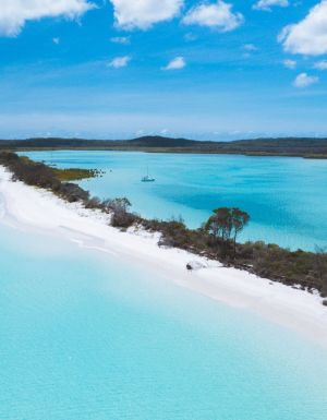
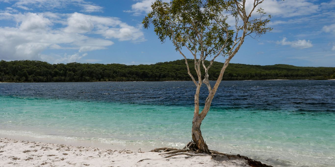
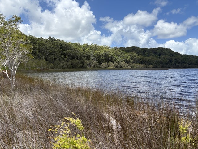
K’gari has more than 40 unique lakes, some more than 55,000 years old. They range from the photogenic clear waters of Boorangoora (Lake McKenzie), pictured above, which filters through the sand dune it rests in, to the emerald-green waters of Lake Wabby, a window lake which is (very) slowly being swallowed by a giant sand dune.

In fact, K’gari is home to more than half of the world’s perched lakes, more than 50, including Boorangoora. Perched lakes form when sand is cemented together with decomposed organic matter (such as leaves and bark), aluminium and iron. This creates an impermeable layer well above sea level. It’s remarkable these lakes exist, given water usually passes quickly through sand.

Until now, it was believed K’gari’s lakes would have contained water since the last ice age ended, about 11,500 years ago. But our new research found some of the island’s deepest lakes dried out only 7,500 years ago. In the current era of climate change, it’s possible this could happen again.

Lake Garawongera is a tannin-stained perched lake, which is isolated from deeper, larger groundwater sources. (Image: John Tibby, CC BY-ND)

The eyes of K’gari

For the island’s Traditional Owners, the Butchulla people, these lakes are the “eyes of K’gari" and their waters are sacred. The Butchulla believe they have been entrusted with an eternal responsibility: to preserve K’gari’s beauty, spirit, waterways and lakes so future generations may experience the same connection.

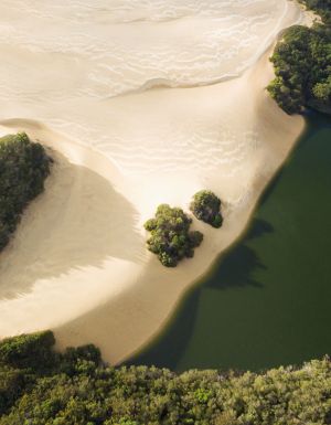
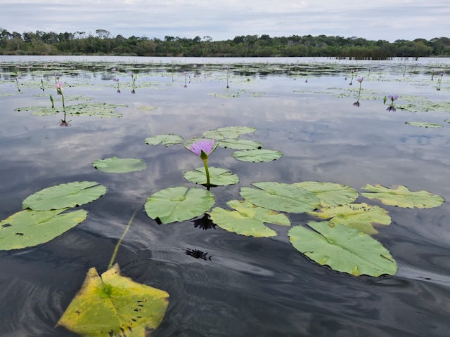
K’gari is home to two key types of lakes. Perched lakes (described above) are the best-known type, while window lakes, filled by rain and groundwater, are so named because they offer a “window" to groundwater below the land.

The climate history of these lakes is recorded in their muddy sediment. What happens in and around the lake gets “written" into the layers: plant pollen tells us about local vegetation while greater amounts of sand might indicate erosion.

Ocean Lake. In the foreground is a day waterlily, an invasive species on K’gari. (Image: Dave Sternberg, CC BY-ND)

A gap in the record

In our research we found this sediment was missing from some of K’gari’s oldest lakes between 7,500 and 5,500 years ago. This gap in the record was identified by radiocarbon dating of sediments from K’gari’s Lake Boorangoora, Lake Allom and Basin Lake.

This gap in sediment suggests the lake basins were not then covered by water. This can happen when there is not enough rainfall over decades. Many Australian lakes dried up during more than the decade-long Millennium Drought.

Our findings were unexpected. We would not have expected the lakes to dry up, as the sediment gap happened during the current Holocene geological epoch, during which global temperatures have varied by less than one degree and moisture has been abundant.

Recent sediment research from another major sand island, Minjerribah (or North Stradbroke Island), shows this island was wetter than K’gari during the same period. Why, at a time of relatively mild climate variation, was it generally wetter just 250 kilometres south? We think southeasterly trade winds supplied rainfall to Minjerribah but not K’gari.

Researchers at Lake Garawongera. From left to right are Conway Burns, Caitlin Jones, Margaux Dupuy, Harald Hofmann and Bob Broome. (Image: John Tibby, CC BY-ND)

Future of a special place

Our findings highlight the pressing need to know much more about K’gari’s beautiful lakes. In a warming climate expected to become drier but punctuated with more intense rainfall, are these lakes at risk of evaporating? At the moment, we simply don’t know.

For most lakes on K’gari, there’s no information about how much water they hold or even how deep they are. The little information available from a few simple surveys hints that lakes were generally deeper in the 1970s.

In response, we have started surveying the underwater depth and topography of the lakes, using automated monitoring devices to measure how much they fill and drop. Gathering data to understand the water inputs and outputs of today’s lakes will help us better interpret the past – and possibly model the future.

While we are concerned about the future of these lakes, K’gari hosts the greatest diversity of fish and amphibians of any Australian island, hinting at a resilience to climate-driven changes.

In our scientific work, we also try to follow Butchulla teachings. These are: what is good for Country comes first; do not touch or take anything that does not belong to you; and if you have plenty, you must share.

“Gung K’gari Marigurim Yaa": K’gari’s water makes voice strong.The Conversation

Lake Allom, on K’gari. (Image: John Tibby, CC BY-ND)

John Tibby, Associate Professor in Environmental Change, University of Adelaide; Conway Burns, Butchulla Aboriginal Corporation, Indigenous Knowledge, and Harald Hofmann, Principal Hydrogeologist, CSIRO

This article is republished from The Conversation under a Creative Commons license. Read the original article.

Australian Traveller

Australian Traveller

View profile and articles
hero media

Exploding supernovas & gold fever: discover the past at this outback Qld town

    Kassia Byrnes Kassia Byrnes
    Under wide-open outback skies, discover a fossicking gem that’s managed to slip under the radar.

    While the name Clermont may feel new to even the most intrepid traveller, its gilded history stretches back centuries. You’ll find it just off the highway, humming quietly under the hazy veil of Queensland’s outback sun. It’s here, hemmed in by mountains and perched atop soil heavy with the earth’s treasures, that one of Australia’s most accessible outback adventures awaits.

    Thanks to deposits of gold, copper and gemstones – souvenirs left by exploding supernovas and the heave of tectonic plates – Clermont became a centre point of Queensland’s Gold Rush. And now? Australia’s fossicking capital is yours to discover.

    Getting there

    car driving along Capricorn Way in queensland
    Take a drive through Queensland’s Mackay Isaac region. (Image: Sean Scott/ TEQ)

    You’ll find Clermont in Queensland’s Mackay Isaac region. To get here, it’s an easy three-hour drive over sealed roads from Mackay. Or, if you’re heading from the Sapphire Fields of Emerald, the drive will carve out just over an hour from your day.

    Whether you’re road-tripping through outback Queensland or just tracing your way through all that Australia has to offer, Clermont is remote but easily accessible.

    Best accommodation in Clermont

    Theresa CreekDam in clermont
    Camp by Theresa Creek Dam. (Image: Riptide Creative/ TEQ)

    All accommodation comes with a generous helping of country hospitality here. The choice is yours between modern hotels, parking up the camper or pitching a tent.

    Theresa Creek Dam lies just outside town. Begin each day with crisp country air and bright outback sunrises. Spend the night under the sparkling country stars and your days out on the dam fishing or kayaking. Even if you aren’t camping, be sure to save space in your itinerary for an afternoon on the red dirt shore.

    To stay closer to town, opt for a central hotel to base yourself between exploring and fossicking, like Smart Stayzzz Inn and Clermont Country Motor Inn.

    Things to do in Clermont

    three people on a tour with Golden Prospecting
    Join a tour with Golden Prospecting.

    One does not visit Clermont without trying their hand at fossicking. There are strict rules when it comes to fossicking, so stick to areas dedicated for general permission and make sure you obtain your license beforehand. Try your luck at McMasters, Four Mile, Town Desert, McDonald Flat and Flat Diggings. To increase your odds, sign on for a tour with the expert team at Golden Prospecting. They’ll give you access to exclusive plots and expert advice along the way.

    Once you’ve tried your luck on the gold fields, head to the Clermont Township and Historical Museum. Each exhibit works like an archaeologist’s brush to dust away the layers of Clermont’s history. Like the steam engine that painstakingly relocated the entire town inch by inch to higher ground after it was decimated by flooding in 1916. See the tools that helped build the Blair Athol mine, historic fire engines, shearing sheds and all sorts of relics that make up Clermont’s story.

    The historic Copperfield Chimney offers a change of pace. Legend has it that fossickers found a solid wall of copper here, over three metres high, kick-starting Queensland’s first-ever copper mine.

    Bush Heli Services flying over clermont queensland
    See Clermont from above with Bush Heli Services. (Image: Riptide Creative/ TEQ)

    For hiking, nearby Dysart is the best place to access Peak Range National Park. Here, mountainous horizons stretch across the outback as if plucked from another world. Set off for a scenic drive along the Peak Downs Highway for access to countless geological wonders. Like the slanting rockface of Wolfang Peak. Summit it, and you’ll find yourself looking out across a scene surely conjured up by Banjo Paterson. Dry scrub dancing in the warm breeze, grazing cattle, eucalypts and the gentle creak of windmills. Don’t miss visiting Gemini Peaks, either, for one of the park’s best vistas, and a blanket of wild flowers after rain.

    Then, take to the skies with a scenic helicopter tour with Bush Heli-Services. Shift your perspective and cruise above all the sights from your trip. Spots like Lords Table Mountain and Campbell’s Peak are best viewed from the skies.

    Before you head home, be sure to explore the neighbouring townships. Spend a lazy afternoon in the shade of Nebo Hotel’s wrap-around verandahs. The hotel’s 1900s dance hall has since been replaced with one of the area’s biggest rodeo arenas, so consider timing your trip to line up with a boot scootin’ rodeo. Or, stop by a ghost town. Mount Britton was once a thriving town during the 1880s Gold Rush. It’s been totally abandoned and now lies untouched, a perfect relic of the Gold Rush.

    Best restaurants and cafes in Clermont

    meal at Commercial Hotel
    Stop into the Commercial Hotel Clermont.

    Days spent fossicking, bushwalking and cramming on history call for excellent coffee and hearty country meals. Luckily, Clermont delivers in spades.

    Lotta Lattes Cafe is beloved by locals for a reason. Start your days here for the best caffeine fix in town and an impeccable brunch menu.

    For a real country meal, an icy cold beer and that famed country hospitality, head straight to the town’s iconic hotel: the Commercial Hotel (known endearingly to locals as ‘The Commie’). It’s been a staple in Clermont since 1877. The hotel even survived the flood of 1916 when it was sawn in two and moved to higher ground.

    Naturally, time spent in the outback must include calling into the local bakery. For delicious pies and a tantalising array of sweet treats, make Bluemac Bakehouse your go-to while in town.

    Discover more of The Mackay Isaac region, and start planning your trip at mackayisaac.com.