Kati Thanda-Lake Eyrethe where, what, when and how

hero media
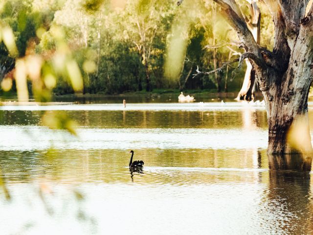
The often dry Kati Thanda-Lake Eyre is an outback enigma, famous for its rare and beautiful floodscapes. A scenic flight over Australia’s largest salt lake is near the top of the outback bucket list so here is everything you need to know: where and when to go, how to get there and just what you’ll see on a scenic flight – wet or dry.

The classic Kati Thanda-Lake Eyre scenic flight

A scenic flight in a small plane is the easiest and best way to truly understand the vast expanse of Kati Thanda-Lake Eyre. There are plenty of companies willing to fly you from further afield, but some of the best ‘local’ scenic flight operators include:

Wrightsair – from William Creek

Bush Pilots Australia from Marree and Hawker (Flinders Ranges)

• Air Wilpena (Flinders Ranges)

For more of a splash-out, you can always include it on your 10-day, around-Australia air safari itinerary. See: Is this Australia’s Greatest Air Adventure?

What are the chances of seeing the lake in flood?

There is a common myth that Kati Thanda-Lake Eyre is entirely dry except for when the big floods happen, like those of 2010/11. While Kati Thanda has only reached capacity three times in the past century, there is often some water somewhere within the 9690-square-kilometre basin.

In 2010 and 2011 the lake’s depth maxed out at 2.2 metres, enough water to fill up its central areas such as Belt Bay. The last time it was considered ‘full’ was way back in 1974 – at a depth of around six metres.

“Around one in 10 years you can expect the big days," says Trevor Wright, whose company Wrightsair has been taking passengers up over the lake since the early ’90s from the nearby town of William Creek. “You might get a run for a couple of years [of a lot of water] and then go a decade without much. Then it becomes a great, white expanse of reflecting salt as opposed to the magical colours."

All the colours of Lake Eyre (photo: Elise Hassey)
All the colours of Lake Eyre (photo: Elise Hassey).

Felicity Brown, chief pilot for Chinta Air, which operates scenic flights from Ceduna and the Flinders Ranges in South Australia, reckons the lake has some water in it about half the time she flies over.

For the lake to truly fill up local rain is important (within 150 to 200 kilometres), but for a big year you also need a torrent from further afield; ideally monsoon rains and perhaps a follow-up cyclone in northern Australia that will get the rivers flowing into Lake Eyre North.

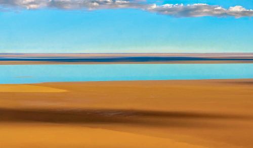
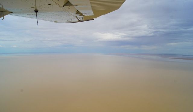
Is it worth flying over when it’s dry?

Yes, yes and yes. It’s an entirely different experience from the intense rainbow of the flooded lake.

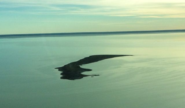
“When there’s no water, especially early in the morning or late in the evening, the lake is sort of like Uluru in that it dramatically changes colour," says Trevor Wright. “At certain times of day, with the very soft light, the white underneath turns a bluish colour, like the sea. Then the peninsulas come out, like continents, so it feels like you’re flying across the world."

Green channels, Macumba River, Lake Eyre
Green channels, Macumba River, Lake Eyre.

“It’s pretty spectacular at any time," agrees Felicity Brown. “The sheer expanse of the lake is the thing that strikes everyone who flies over it – water or not.

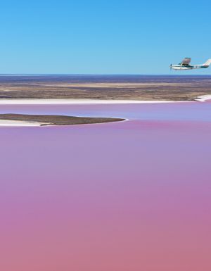
“If it’s dry, you get this glimmering white salt pan stretching out off into the distance or if it’s rained, the water stretches off to the horizon, looking like the inland sea that I’m sure some of the early explorers thought it was."

Highlights – what’s to see?

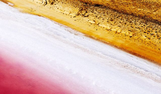
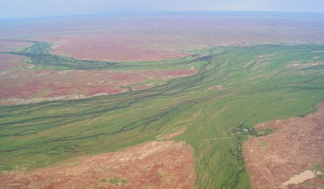
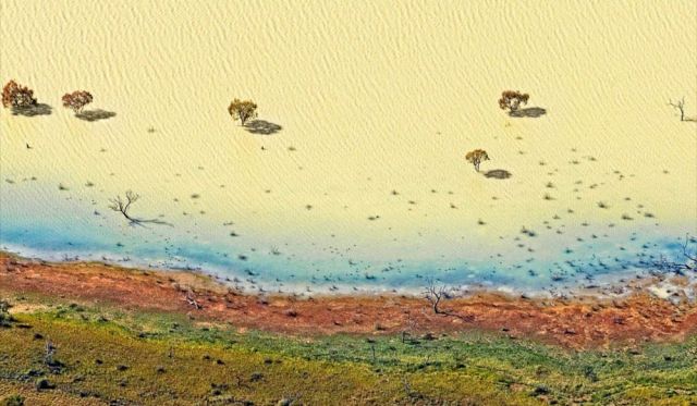
When the rains and monsoon waters align, the outback in and around Lake Eyre comes to life, attracting fish and birdlife en masse. If you’re lucky, you’ll also catch an eyeful of the famous pink hue off the lake, caused by a micro algae known as dunaliella salina, common in salt water and other pink lakes of Australia.

“The best part of a flight over Lake Eyre is flying over the creeks and the waterways leading into the lake – that’s where you’ll see the most birdlife," says Felicity Brown. “Things like pelicans (in a big year) and all sorts, like banded stilts and wrens, plus plenty of the usual outback birds, like crows and galahs."

One of the most popular routes for scenic flights is to head up the Warburton Groove and Warburton River and come back down the Birdsville Track (you may need to take an extended flight to reach this area, depending on where you take off from). There’s plenty to see on Eyre’s periphery too.

Warburton Groove (Kati Thanda) Lake Eyre North.
Looking up Warburton Groove (Kati Thanda) Lake Eyre North.

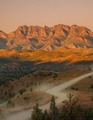
“My highlights are the huge erosion on the dunes at the north end of the lake in the Tirari Desert," says Trevor Wright. “The diversity of coloured sandstone is amazing."

Can I drive to Kati Thanda-Lake Eyre?

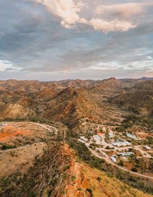
Yes. Kati Thanda-Lake Eyre’s two hubs are the tiny towns of Marree (95 kilometres south) and William Creek (60 kilometres south-east), where you can arrange scenic flights.

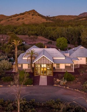
At William Creek (at the centre of Australia’s largest cattle station, Anna Creek) there is a hotel, garage, restaurant (when it’s busy) and a caravan park with en-suite rooms and camping. It is on the Oodnadatta Track and offers easy access to the lowest point in the lake (and in Australia), which is 15 metres below sea level. William Creek can be accessed via Coober Pedy (170 kilometres) by the unsealed William Creek Road (okay for 2WD when it’s dry).

Marree is more accessible from the Flinders Ranges side, and is the starting point of the Birdsville Track (685 kilometres north of Adelaide). There is accommodation, fuel and, of course, a pub here. It’s possible to drive to Marree from the Flinders only passing a couple of short stretches of gravel.

Silcrete Island, Belt Bay, near the lowest point in Australia (on Lake Eyre). photo: Wrightsair.

Note: Obviously a 4WD is preferable for both these journeys, especially if you want to drive to the lake’s edge (no driving on the lake). The public access routes (pastoral tracks) are suitable for 4WDs only. Plan well ahead if you’re planning a summer trip out this way (fuel, water, food, extra spares etc) because the temperature can head into the 50s (yes, 50s) between November to March.

Strange, strange lake indeed

In the big deserted patch of outback Australia, strange, strange things can happen.

“From time to time you see unidentified flying objects around the lake because you’re in a really remote area," says Trevor Wright. “It gets really dark at night and tends to accentuate anything that’s moving through the area.

“About five or six times a year, in the right weather conditions, you can also get a salt fog over the lake. So up to about 100 metres it’s like being in a thick impenetrable fog, but it’s actually salt. It’s spooky."

When there’s water in the lake, flying over it can bring its own challenges too.

“You have to be really on your guard when it’s overcast and it’s a blanketed dark sky," says Wright. “You can lose your horizon, and the water will blend into the horizon – it’s just one big expanse. You can also lose your depth perception. But you just use your instruments so it’s still safe."

There’s even a Lake Eyre Yacht Club

Bob Backway founded the Lake Eyre Yacht Club (LEYC) in 2000. There are 230 members, from all over Australia, and even one from Texas.

The Marree-based club holds a regatta that can include 100 people, like back in 2010 when “for the first time in 20 years Cooper Creek made it to Lake Eyre," according to Commodore Bob, who says he sails on Eyre in some capacity about every two years.

People first started sailing there in earnest during the big floods of 1974. And when this part of the outback is in flood, the sailors go crazy.

Desert River by Peter Elfes
Desert River from Peter Elfes’ The Green Desert.

“In a good year there are hundreds of other lakes, and a couple of thousand kilometres of temporary rivers, some as big as the Murray, in the desert and it’s sort of a competition to find a new lake and sail in it," says Bob. “You can go out over the horizon so when you run aground you stand up and can’t see anything but water and you have to use your compass to get back."

The facts: Eyre by numbers

• Is 144 kilometres long and 77 kilometres wide (Lake Eyre North). Lake Eyre South is 64 kilometres long east-west and 24 kilometres wide

• Is Australia’s lowest point (15 metres below sea level) and its drainage basin covers 15 per cent of the continent. The two lakes are joined by the 15-kilometre-long Goyder Channel

• Is Australia’s largest salt lake and the 13th largest lake in the world

• Is located in northern South Australia but its catchment area extends to New South Wales, Queensland and the Northern Territory.

• Eyre hosted the 1964 world land-speed record by Sir Donald Campbell, in the Bluebird (710 kilometres per hour).

hero media

The road trips and trails you need to experience in Victoria now

Wind through fern tunnels, stop for a wine in a tram bar, or chase giant murals across the wheatbelt. These drives and rides prove Victoria’s best stories are found off the straight and narrow. 

There’s something unmistakably Australian about a road trip: car packed, playlist on, landscapes shifting. Travelling down the highway toward Healesville, in Victoria’s Yarra Valley , the mountains rise, flanking me on both sides. I feel its embrace, a silent invitation to explore what lies beyond.  

Moss-covered embankments rise on either side, and towering mountain ash trees form a green tunnel overhead. Road signs warn of wombats and cyclists but with giant ferns lining the roadside, the landscape feels prehistoric, as if a dinosaur might suddenly emerge. This, the Black Spur , is one of my favourite road trips. 

The Black Spur 

The Black Spur drive
Through the forested canopy of The Black Spur drive that winds from Healesville to Narbethong. (Image: Neisha Breen)

Location: Yarra Ranges
Duration: 30 kilometres / 30 minutes 

The Black Spur is short compared to other Victorian road trips, just 30 kilometres, stretching from Healesville to Narbethong. But what it lacks in distance, it makes up for in scenery. Just outside Healesville, Maroondah Dam offers bushwalks and scenic views. However, if pressed for time, Selover’s Lookout is an easy roadside stop offering uninterrupted views of the dam.  

In Narbethong, close to the Marysville’s snowfield, is the Black Spur Inn , a charming double-storey brick hotel that’s been welcoming travellers since 1863. Here, diners cosy up by the roaring fire or gaze through the floor-to-ceiling windows, imagining horse-drawn coaches carrying hopeful gold seekers to the eastern goldfields.   

Victoria’s Silo Art Trail 

Silo Art Trail
The Silo Art Trail in the Wimmera Mallee region. (Image: Visit Victoria/Anne Morely)

Location: Various towns across the Wimmera Mallee region
Duration: More than 200 kilometres / 4–5 hours but best over a minimum of three days  

What began as a way to draw travellers back into town bypassed by highways – places such as Nullawil, Sea Lake and Patchewollock – has grown into a celebrated outdoor art movement. The Silo Art Trail now includes 23 silos, each transformed with large-scale mural portraits sharing local stories, celebrating community heroes, Indigenous history, farming life, or regional identity.  

The Nullawil silo, for example, is a portrait of a local farmer in a chequered flannelette shirt alongside his loyal kelpie, painted by artist Sam Bates (AKA Smug). And the silos at Albacutya in the Grampians, painted by artist Kitt Bennett, depict her joyful memories of growing up in the countryside. Many of the murals sit right in the heart of small towns, such as Rochester and St Arnaud , making them perfect spots to pause for a country pub meal or something sweet from a local bakery.   

Metung to Mallacoota  

Gippsland lakes
Gippsland Lakes. (Image: Visit Victoria/Josie Withers)

Location: Gippsland
Duration: Approximately 220 kilometres / 4 hours  

The Gippsland Lakes are a much-loved holiday spot in Victoria, but road-tripping further east reveals much more. Begin in Metung and time your visit with the monthly farmers’ market, or simply linger over lunch on the lawn of the Metung Hotel. Twenty minutes away is Lakes Entrance , where you can watch the fishing boats return with their catch. 

Lakes Entrance
Lakes Entrance. (Image: Visit Victoria/Iluminaire Pictures)

Continue to Marlo, where the Snowy River spills into the sea, and Cape Conran for its many beaches and walks. If needing to stretch your legs, Croajingolong National Park is home to the historic Point Hicks Lighthouse and the Wilderness Coast Walk. Birdwatching and rainforest trails near Bemm River are worth a pit stop before arriving in Mallacoota, where the forest meets the sea. 

Great Ocean Road 

12 Apostles on the Great Ocean Road
The 12 Apostles on the Great Ocean Road. (Image: Tourism Australia/Two Palms/Harry Pope)

Location: South-west Victoria, from Torquay to Allansford
Duration: Approximately 250 kilometres / 4–5 hours but best over a minimum of three days  

Victoria’s most famous road trip delivers it all: world-class surf breaks, rainforest walks, clifftop lookouts and wildlife encounters. The journey begins in Torquay, the state’s surf capital, then hugs the coast past Anglesea and Lorne to Apollo Bay, before curving inland through the lush rainforest of the Otways. Stop at Cape Otway Lightstation or take to the treetops at Otway Fly.  

Between Cape Otway and Port Campbell lies the most photographed stretch – seven of the Twelve Apostles still standing, alongside the golden cliffs of Loch Ard Gorge. Further west, Warrnambool is a winter whale-watching hotspot, before the road winds to Port Fairy, a charming fishing village of whalers’ cottages, walking trails and offshore seal colonies further along the coast. 

Bellarine Taste Trail 

Terindah Estate
Terindah Estate. (Image: Visit Victoria/Emily Godfrey)

Location: Bellarine Peninsula
Duration: Approximately 80 kilometres / 2–3 hours  

The Bellarine Taste Trail is a feast for the senses, winding through coastal towns, past boutique wineries and artisan producers. It’s a choose-your-own-adventure style trail – simply grab a map and build your own delicious journey.  

You might wander historic, seafront Queenscliff, sip wine in a converted tram bar at Terindah Estate , sample a locally distilled whisky at The Whiskery in Drydale or pick up a jar of honey at Wattle Grove in Wallington. Seafood lovers can head to Portarlington, famous for its mussels. Eat them fresh at local restaurants or head out on the water with Portarlington Mussel Tours. 

O’Keefe Rail Trail – Bendigo to Heathcote 

Pink Cliffs Reserve
Pink Cliffs Reserve in Heathcote can be seen on the O’Keefe Rail Trail. (Image: Visit Victoria/Emily Godfrey)

Location: Central Victoria
Duration: Approximately 50 kilometres / 4 hours cycling 

Travellers first journeyed between Heathcote and Bendigo in 1888, when the railway line was built to link the towns. Trains stopped running in 1956, but today the route has a new life as the O’Keefe Rail Trail . The path is mostly level for easy riding, and along the way you’ll cycle past bushland, waterways and reserves. There are plenty of places to picnic, birdwatch, and if you’re lucky, spot a platypus.  

The trail is well supported with water stations, bike repair points, shelters, and signage. Axedale makes a great halfway stop, with the pretty Campaspe River Reserve for a rest and local cafes for refuelling. Begin in Heathcote, known for its wineries and cafes, or in Bendigo, which is easily reached by train from Melbourne/Naarm. Shorter sections, such as Heathcote to Axedale, are also popular. 

Goldfields Track – Ballarat to Bendigo 

Location: Central Victoria
Duration: Approximately 210 kilometres / 2–3 days cycling  

The Goldfields Track traces a route once so rich in gold it made Melbourne one of the wealthiest cities in the world. Starting at Mt Buninyong, south of Ballarat, the trail leads mountain cyclists and walkers north through Creswick, Daylesford and Castlemaine before finishing in Bendigo. Along the way, you’ll encounter granite outcrops, eucalypt forests, rolling farmland and remnants of the region’s mining past.  

As it passes through the lands of the Dja Dja Wurrung and Wadawurrung people, the track shares gold rush history and Indigenous stories brought to life by interpretive signs. Walk or ride the full trail or choose from one of its three distinct sections. With cosy stays, cafes and pubs, it’s easy to mix wilderness with comfort.