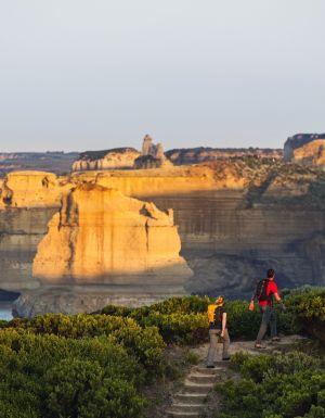
The ever-shifting sands of Lake Mungo National Park are Australia’s window into deep time, where people sat, cooked and talked tens of thousands of years ago. Professor Dirk HR Spennemann has ventured this way before. But he never tires of taking the journey, and it always leaves its mark.
No matter how often I go back, I’m captivated by the richness and magic of Lake Mungo. A visit here is a visit to deep time.
Don’t expect to go for a dip, though; the last time this Lake was full was some 14,000 years ago. As one of the overflow lakes of Willandra Creek, Mungo filled and dried up in keeping with the rainfall patterns dominating the Murray-Darling Basin at the time.
Between 50,000 and 12,000 years ago, these fluctuations of wet and dry saw layers or sand (wet) and clay (dry) deposited on the downwind side of the lake, building up a 30m tall dune that envelops the eastern side of the lake like a giant crescent – hence the name “lunette".
These sand layers are the richest lode of information about environmental conditions in early Australia, and about the people that lived there. Burials found in the lunette date back more than 40,000 years. The Mungo remains are the oldest anatomically modern humans found outside Africa.
One of the burials is considered the world’s oldest ritual cremation. Combine this with the find of several hundred 20,000-year-old human footprints and it comes as no surprise that the Willandra Lakes World Heritage Area has archaeologists excited all over the globe.
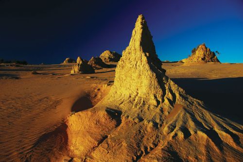
Interestingly, these unique discoveries were made only because the lunette was continually eroded, thanks to rabbits and overstocking with sheep in the late 19th Century. When exploring the area, you’ll encounter a scarred landscape. Pinnacles of sand dot the gently rising dune, standing silent witness to the former height and size of the lunette.
When you connect the dots in your mind, mentally joining the tops of the formations, you’ll understand how much soil has been lost. Well, not lost altogether, as it’s on now the other side of the lunette, forming sweeping dunes of pure yellow sand.
The formations are fragile. Wind and occasional rain contribute to their gradual decay. Climbing them, as tempting as it may be to gain a different vantage point, is strictly prohibited. Moreover, every step you take on the lunette will loosen some of the ground, contributing to the erosion of a truly unique archive of Australia’s history.
On a windy day, you’ll see the sand blowing away over the dune. This continual gradual erosion also exposes a seemingly never-ending series of Indigenous Australian stone artefacts, fireplaces with fragments of termite mounds that served as heating retainers and animal bones. If you keep an eye out, you’ll see ancient food remains such as emu eggshell (now bleached white), freshwater mussels from the lake, fish vertebrae and bones from various marsupials.
On occasion, a burrow of a wombat or a bettong will be exposed, often with bone remains in place, several thousand years after the inhabitant has perished. It’s also strictly forbidden to interfere with artefacts and remains and visitors need to resist the temptation to pick them up – even if only to examine them close-up. Let them rest where they lie.
Given the fragility of the site, it’s a great privilege that as traditional custodians the three tribal groups of the area, the Mutthi Mutthi, the Ngyiampaa and the Paakantyi, want to share Lake Mungo with the rest of the world and allow us to visit and experience this truly unique place. And our part of that generous bargain is to make sure our presence here as visitors creates as little impact as possible.
Every step you take on the lunette will loosen some of the ground, contributing to the erosion of a truly unique archive of Australia’s history.
Many visitors return to the lunette to watch the sunset, and it’s easy to understand why. This is a magical experience: as the sun loses its power, the formations, so stark white and pink during the day, attain a rich golden yellow and orange colour.
On clear, cloudless and moonless nights you’ll see the Milky Way in all its glory, spanning the sky from horizon to horizon. And in the middle of that band of stars is a giant emu. We’re so conditioned to looking for patterns of white stars against the black that it takes a mental shift to see it: the emu is black space against a white background.
I personally think that the emu is a metaphor for the mental shift visitors undergo the first time they visit Lake Mungo. You can’t help but be overpowered by the depth of Indigenous antiquity here, where 1788 pales into utter insignificance.
But the past 200 years haven’t gone unnoticed in the region. Large grazing runs set up in the mid-19th century gave way to smaller properties. Pastoral stations and their associated structural paraphernalia, such as woolsheds, abound. The most spectacular is the Mungo Woolshed, right next to the visitor centre. Initially, a shed for 30 blade shearers, the imposing 36m-long building was erected from locally cut Cypress pine logs in the late 1870s.
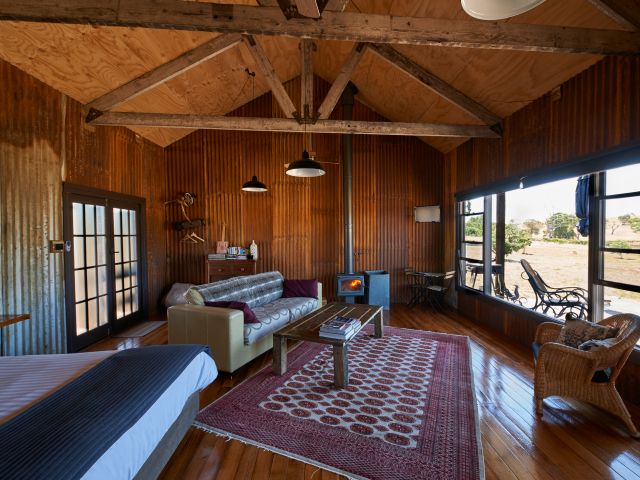
For the past 15 years, I’ve been coming to Mungo at least once a year with a group of mature age university students. I prefer to stay at the Mungo shearers’ quarters, a small, secluded compound next to the visitor centre and in view of the woolshed. There can be no better start to a day than a fresh cup of coffee or tea in hand, watching the sun emerge over the lunette on the horizon, dousing the woolshed in warm red and orange.
A few years back the original heritage-listed shearers’ quarters at Mungo burned down, but they’ve since been replaced with modern, well-equipped, air-conditioned rooms built in keeping with the style. And, quite understandably, they’ve become very popular.
This year, the quarters were all booked up well in advance and as a small group, we were put up at Leaghur Station, some 15km north, at the edge of Lake Leaghur. It had been an operational sheep station until 1995 when Leaghur was acquired by the Australian Government as part of a changed management strategy for the World Heritage Area. Today the homestead is the residence of one of the park workers and the shearers’ quarters are used for groups.
The quarters set a stone’s throw from the shearing shed, are basic but very authentic and illustrative of the conditions shearers face on stations throughout the region: small bare rooms with twin beds and a few hooks on the wall. A separate building houses a large and well-equipped kitchen and a common room. Set to the rear are separate toilet and shower buildings, as well as a fly-proof meat house.
Visitors from regional (let alone metropolitan) Australia are always struck by how quiet it is out there. But at the Mungo shearers’ quarters, you can still hear the occasional car coming from the campground as campers make use of the warm showers provided at the visitor centre. Leaghur Station, on the other hand, is dead quiet, the only sound being the soft wind or the quiet thumping of a kangaroo hopping about in the starlit night. And at Leaghur the sunrise is no less spectacular either. Based on that experience, I know where I’d like to stay next year.
Need to know
The best time to go to Mungo is in spring and autumn when it’s not too hot during the day and not too cold at night. The National Park and Wildlife Service provides special educational tours and programs during the summer and Easter school holidays. Nothing beats a guided tour provided by one of the traditional landowners.
The visitor centre is a good and necessary starting point for a visit. Not only does it contain a display of the heritage you’ll encounter, but it also provides up-to-date info on local conditions and access restrictions, if any.
While most visitors are content with a visit to the lunette (10km away across the lake bed), there are other opportunities, including a 1km Grasslands Nature Walk (suitable for wheelchairs), a 2.5km Foreshore Walk near the visitor centre and a 65km, 15-stop drive tour that takes you around the back of the lunette, taking in natural and cultural aspects of the park.
For photographers
The focal point for photography is obviously the lunette. Shooting the formations during the middle of the day poses a challenge, as there’s generally little contrast. As the sun gets lower, the erosion scars cast shadows and give structure to the formations. The most magic images are taken at sunset, but don’t expect the lunette to glow deep red just before the sun goes down; the colour is at its best and richest about 20min before sunset, after which the sun loses its power and the colours begin to appear cold and lifeless.
Unless you walk over the lunette and plan on shooting the sunrise reflecting on the wind-deposited sand dunes, the publicly accessible part of the lunette doesn’t make for great sunrise images. Be aware that the lunette can be closed to visitation during and after rain to protect it from erosion.
Worth considering is shooting sunrise over the majestic Mungo woolshed. The pine logs will provide ample opportunity, both from outside and inside the woolshed. As always, it’s worth scouting locations the day before.
Even though the cultural environment is the main attraction, there are additional options for the photographer. After a brief rain, the normally dusty saltbush will look deep green, set against a deep red soil. In addition to photographing the “standard" wildlife (kangaroo, emu, wedge-tailed eagle), macro photography of the saltbush may yield surprising results.
A word on equipment: while a standard lens or mid-range zoom will serve you well, a wide-angle, or even ultra-wide angle, will allow for dramatic shots of the formations. A circular polarization filter will enhance colours and sky contrast. Using a tripod is desirable, but not essential unless you plan on using low ISO and high f-stops for the sunset shots. Be mindful of the windblown sand, which you may encounter as you ascend the lunette. The smart money is on a camera bag or light backpack even if it doesn’t look windy at the car park.
Getting there
The approach is from three main directions: from Balranald (150km, approx 110km of which is on dirt roads); from Ivanhoe (180km, approx 120km on dirt); and from Mildura (110km via the Arumpo Rd, approx 90km on dirt). The shortest distance on dirt (60km) is from Mildura via the Pooncarrie Road (200km). You don’t need a 4WD, but you should have a car with reasonable ground clearance and be prepared for sandy, washboard, and occasionally rutted roads.
Some or all roads may even be closed due to wet weather (to avoid them being churned up by vehicles), which means you can’t get in, but also that you can’t get out. The roads normally dry quickly. If rain is forecast for the wider region, it’s advisable to call the NSW National Park and Wildlife Service Regional Office at Booranga for advice (03 5021 8900). Vehicle fee $7 per day.
Staying there
Low Budget // There are two campgrounds, one on the western lakeshore about 2km from the visitor centre (which also has showers and additional toilets) and one at the back of the lunette (Belah Campground, 27km from visitor centre). Fees ($5 adult, $3 child) are paid at the visitor centre.
Budget // Mungo Shearer’s Quarters, five air-conditioned, modern rooms, two with twin bed and a bunk bed, one with twin bed and a single bunk above, two with three bunk beds (all bring own bedding). Self-catered, kitchen facilities, showers, toilets, $30pp. Leaghur Station Shearer’s quarters (groups only), about 15km from the visitor centre, six rooms, one with single, five with twin beds. Self-catered, kitchen facilities, showers, toilets, $20pp. Book via the NSW National Park and Wildlife Service Regional Office at Booranga (03 5021 8900).
Upmarket // Mungo Lodge, air-conditioned cabins, eight twin unit cabins with double and a single bed each unit, self-contained cabin (sleeps four), meals and bar available (dining also open to casual visitors). Rooms with ensuite $250, self-contained cabin $350 (both options twin share, $65 extra person, 03 5029 7297, www.mungolodge.com.au ).
Day tours
Those who do not wish to drive themselves and/or stay overnight can avail themselves of a day tour operating from Balranald, try Outback Geo Adventures .