A guide to Phillip Island’s best walks

hero media
Explore shipwrecks, come face-to-face with Highland cattle, and drink in panoramic views on these six Phillip Island walks.

Surrounded by a blustery, rugged coastline, and encompassing a patchwork of verdant, rolling farmland, where cattle and sheep graze, Phillip Island is a rambler’s delight. Whether you’re after a short scenic walk with the kids, or a lengthier hike with friends, these six walks should stand you in good stead.


Don’t miss: Top things to do on Phillip Island

Churchill Island Walks

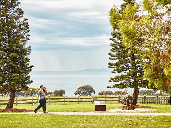
Connected to Phillip Island via a bridge, this small, little-known island is home to a working farm that’s among the oldest in Victoria, and a restored homestead and cottages that date back to the 1860s, all of which are open to the public and popular with families. The most famous local residents here are arguably the farm’s shaggy Highland cattle.


The isle is home to three different walks: the Churchill Island loop, which takes around two hours to complete; the easier North Point loop, which takes just one hour to complete; and the Wadjil’garook Wetland, which is really more of a brief stroll, but includes insights into Aboriginal culture, and offers an opportunity to see wetland birds.


Toast to a walk well done with a flat white at the island’s cafe, which has a rather tempting yet wholesome breakfast and brunch menu too, brimful of locally sourced produce. Bear in mind that the farm grounds are managed by not-for-profit Phillip Island Nature Parks , and ticketed (adults are priced from $13.50, and children aged between four and 15-years-old are priced from $6.75), but entrance to the walks alone is free.

walkers on Churchill Island
Walk among the history of Churchill Island.

Pyramid Rock to Berrys Beach

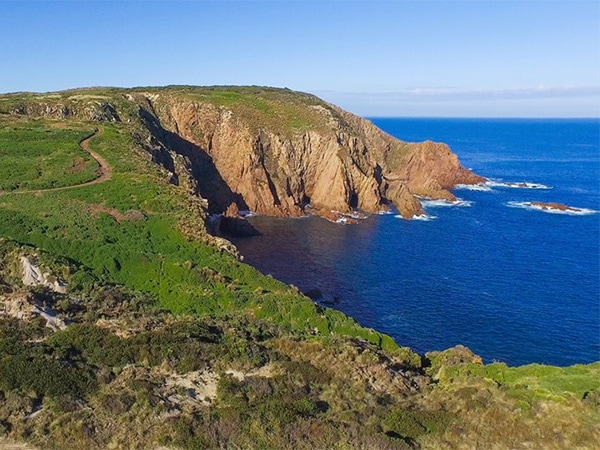
A meandering clifftop track that affords walkers beautiful coastal views, this walk from Pyramid Rock to Berrys Beach takes around two hours return, though you may want to factor in more time to savour the views from the lookout points, snap a photo or two for Instagram, and spot creatures of the deep… Between May and October migratory killer whales, southern right whales and humpback whales are known to cruise through these very waters, as they head from Antarctica towards Queensland’s warmer climes for calving.


Along the five-kilometre walk you’ll marvel at the black basalt columns of Pyramid Rock, trace the green and gold of the coastline’s scrubland and swathes of tussock grass, and finally, you’ll wind up at the sweeping, secluded Berrys Beach.
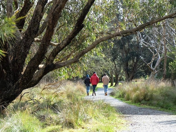
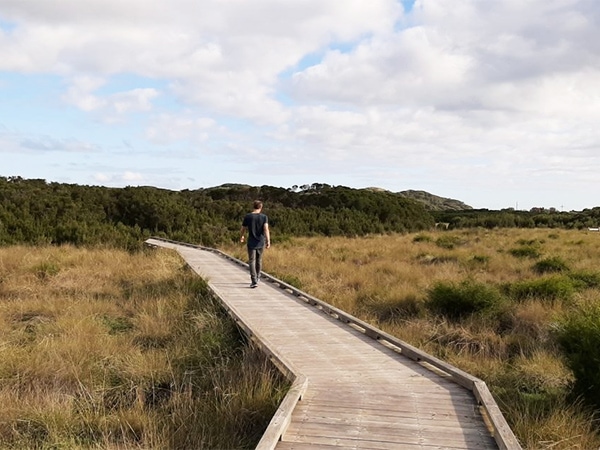
Views of Phillip Island's Pyramid rock
Pyramid rock affords walkers beautiful coastal views.

Swan Lake Walk

A short and mostly flat, kid-, pram- and wheelchair-friendly walk that skirts freshwater Swan Lake in the island’s west, this short trail is partly comprised of boardwalks and takes in two bird hides near the lake’s edge. Walkers will wander through bushland, past tea trees, banksia and native grasses, and may spot black swans, swamp harriers, cormorants, purple swamp hens and more on their journey. It’s a 1.3-kilometre walk that takes just 20 minutes from start to finish.

Journey through freshwater Swan Lake in the island’s west.

Scenic Estate Conservation Reserve Walks

This birdlife-rich 28-hectare site provides a habitat for six species of threatened birds, and also overlooks a World Heritage-listed Ramsar wetland. Stroll among endangered grasslands and vegetation, while soaking up the bay views that stretch to Churchill Island, Rhyll and beyond. In among the natural bushland setting you’ll also find two scenically situated picnic shelters, perfect for enjoying a lazy lunch al fresco – just don’t forget to pack provisions.


There are 1.5 kilometres of walking tracks to explore, so you can pace your walk accordingly, whether you’re in the mood for a brief outing or an extended ramble in the fresh air.

Scenic Estate Conservation Reserve Walk.
Boardwalk beauty at Scenic Estate Conservation Reserve Walk.

Don’t miss: A guide to Phillip Island’s best beaches

Cape Woolamai Walks

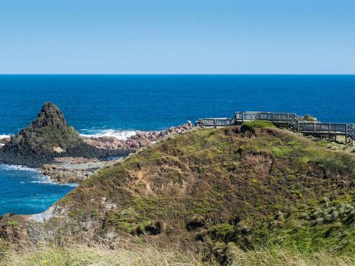
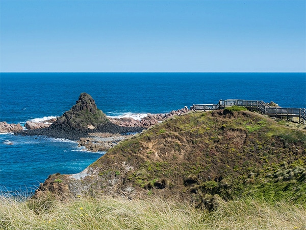
Venture up to the heady heights of Cape Woolamai, the highest point on Phillip Island, and gorge on panoramic views. Part of the Cape Woolamai State Faunal Reserve, which plays host to short-tailed shearwater (aka muttonbird) rookeries, you can choose your own adventure from the three walking tracks, all of which start from the reserve’s carpark. The Cape Woolamai Beacon Walk (follow the black markers) takes around 3.5 hours return; The Old Granite Quarry Walk (follow the blue markers) is six kilometres long and takes a total of three hours to complete; and the shorter Pinnacles Walk (follow the green markers) takes around two hours return. On both the Cape Woolamai Beacon Walk, and the Pinnacles Walk you’ll gaze down upon a cluster of spindly sea stacks that rise up out of the frothy surf, a local landmark known as The Pinnacles.

 Cape Woolamai in Phillip Island
Venture up to the heady heights of Cape Woolamai.

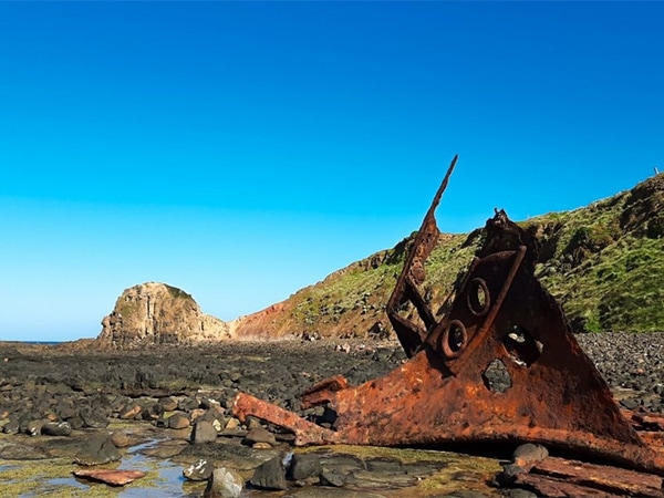
Kitty Miller Bay Walk

 Combine a spot of rockpooling and shell collecting with a visit to the rusted remains of an old shipwreck on this one-hour-long walk. First you’ll amble down a wooden stairway that leads to the shores of snug little Kitty Miller Bay, then follow the curve of the beach to your left, before finally landing at the site of the SS Speke, which ran aground on Phillip Island back in 1906. Ensure your visit coincides with the low tide, otherwise access will be limited.

SS Speke shipwreck
SS Speke ran aground on Phillip Island back in 1906.
Chloe Cann
Chloe Cann is an award-winning freelance travel and food writer, born in England, based in Melbourne and Roman by adoption. Since honing her skills at City St George's, University of London with a master's degree in journalism, she's been writing almost exclusively about travel for more than a decade, and has worked in-house at newspapers and travel magazines in London, Phnom Penh, Sydney and Melbourne. Through a mixture of work and pleasure, she's been fortunate enough to visit 80 countries to date, though there are many more that she is itching to reach. While the strength of a region's food scene tends to dictate the location of her next trip, she can be equally swayed by the promise of interesting landscapes and offbeat experiences. And with a small person now in tow, travel looks a little different these days, but it remains at the front of her mind.
See all articles
hero media

Taking the route less travelled along the Great Ocean Road

The Great Ocean Road has captured the hearts of Australians with its astounding scenery since 1932, but going off-course can enrich your experience with untouched nature, foodie delights and charming towns. 

It’s a chilly 16 degrees. My husband pulls on a steamer and jogs – as all seasoned surfers do – into the water. We’re at Bells Beach , the legendary break on Victoria’s Surf Coast that’s home to the Rip Curl Pro, the world’s longest-running event in competitive surfing. Each year, over the Easter long weekend, up to 40,000 people descend on the region for the event. Today, though, we have the beach almost to ourselves, and the less-than-favourable temperature doesn’t deter my husband from surfing this famous break.  

Bells Beach
Bells Beach is known for its epic surf break and is at the start of the Great Ocean Road. (Image: Tourism Australia)

Torquay to Anglesea and Aireys Inlet 

Split Point Lighthouse
The red dome of Split Point Lighthouse in Aireys Inlet. (Image: Tourism Australia)

The nearby surf town of Torquay marks the starting point for the Great Ocean Road . Unfolding our map, which we have marked out with a highlighted route for our children to follow, we set off for lesser-known Anglesea, a chilled-out town 20 minutes south of here. Its wide, sandy beach is a gentler swimming option for our young family. Groms can learn to surf here with Go Ride a Wave, which also runs stand-up paddle boarding on the Anglesea River.  

Split point lookout
The lighthouse overlooks the Shipwreck Coast. (Image: Tourism Australia)

After a couple of nights in Anglesea, we hit the road again, first stopping at Aireys Inlet. Here we stretch our legs at Split Point Lighthouse, which was made famous by the 1990s television series Round the Twist, before driving under the Memorial Arch that welcomes us, officially, to the Great Ocean Road.  

This 243-kilometre coastal road was built by returned First World War servicemen and serves as a permanent memorial to those who fought and died during the war. Carved into rock using hand tools and horse-drawn carts, it was a huge engineering feat and provided much-needed access to isolated coastal communities. 

Lorne to Birregurra 

Lorne is a delightful beachside stop for lunch and browsing boutique stores. It’s also the gateway to Great Otway National Park , which comprises a varied landscape of old-growth forests, cool-temperate rainforests, heathy woodlands and rugged coast. With the highest rainfall in Victoria, the region is home to many waterfalls – 10 of which are within 10 kilometres of Lorne.  

Turning slightly off the main drag, we wind along a gum-shaded road to Erskine Falls. Here, our son leads the way through the hyper-green rainforest and down 200-plus stairs to the cascade that drops 30 metres into a lush fern gully. We hop over large boulders to get closer to the falls, enjoying the entire place to ourselves; it’s worth the return climb.  

From Sheoak Falls Picnic Area, there are walking trails to Henderson Falls, Phantom Falls, Won Wondah Falls and Kalimna Falls, some of which follow an old timber tramway from forest-logging days, which only came to an end in 2008.  

Erskine Falls
Erskine Falls is one of many falls within a day trip of Lorne. (Image: Visit Victoria)

You can follow your appetite north to the town of Birregurra, which is part of the Otway Harvest Trail that connects farm gates, markets, wineries, breweries and distilleries. It’s home to three-hatted modern Australian restaurant Brae , helmed by celebrated chef Dan Hunter, set among native gardens and an organic farm, and Otways Distillery, which produces small-batch spirits using local produce and botanicals.  

Brae restaurant
Brae is a three-hatted restaurant in Birregurra. (Image: Tourism Australia)

Apollo Bay to The Otways 

Back on track, the cliff-hugging stretch between Lorne and Apollo Bay is breathtaking. At Teddys Lookout, we overlook the winding road ahead and St George River spilling into the ocean. We spend languid days in Apollo Bay, a buzzy seaside town that boasts a three-kilometre-long, crescent-shaped beach with a backdrop of rolling green hills. One evening, as the sun sets, we take the steep 10-minute walk to Marriners Lookout, which affords panoramic views of the ocean, hinterland and town.  

A 15-minute drive along the road, Maits Rest is a lush rainforest gully that has been protected since the early 20th century. Wandering along the 800-metre boardwalk, we inspect the delicate moss-covered forest floor and the gnarled roots of 300-year-old myrtle beech trees, then crane our necks to see their canopies, some 50 metres above us. It’s therapy in nature.  

Cape Otway to the Twelve Apostles 

Twelve Apostles
One of the famous Twelve Apostles, limestone sea stacks that rise from the Southern Ocean. (Image: Ben Savage)

The southernmost tip of Cape Otway is a delightful detour, home to the 1848-built Cape Otway Lightstation, the oldest surviving lighthouse on mainland Australia. We climb the narrow winding staircase to the gallery deck, explore the keepers’ quarters and telegraph station, and enjoy a coffee and some ‘famous’ scones at the charming onsite cafe.    

It’s a pinch-me moment to finally see the Twelve Apostles in person. This unmistakable cluster of limestone stacks rising abruptly from the sea were never 12, however. When coined this in the 1890s as a marketing ploy, there were only nine; today, only seven remain after two collapsed in 2005 and 2009. We admire these Aussie icons from the viewing platform, in awe of Mother Nature’s ever-evolving artwork.  

The Grotto
The Grotto is another natural attraction within Port Campbell National Park. (Image: Carmen Zammit)

Edging the wild Southern Ocean, this part of the coast – dubbed Shipwreck Coast – is made up of many sea-carved natural wonders including London Bridge, The Grotto and Gibson Steps. After exploring the lookout trails of Loch Ard Gorge/Poombeeyt Kontapool – its English name taken from the site of the 1878 shipwreck – we nestle into the sandy beach encircled by towering sandstone cliffs, as our children splash about on the water’s edge, and soak it all in.  

Port Campbell to Timboon 

Timboon Fine Ice Cream
Timboon Fine Ice Cream is part of a regional foodie trail. (Image: C McConville)

Just north of Port Campbell National Park, the region of Timboon is part of the 12 Apostles Food Artisans Trail, filled with purveyors of delicious foodstuffs such as Timboon Fine Ice Cream , Timboon Railway Shed Distillery and Apostle Whey Cheese. As an antidote to the indulgence, the 20-kilometre Poorpa Yanyeen Meerreeng Trail is a self-guided ride or walk between Port Campbell and Timboon through tall forests, over historic bridges and past sparkling lakes and farmland with grazing cattle.  

Warrnambool to Port Fairy 

Warrnambool building
A 19th-century building in Warrnambool. (Image: Peter Foster)

In Warrnambool, a town rich in maritime history, we take the four-kilometre Thunder Point Walk that traces the coast. The kids squeal when an echidna shuffles out from beneath the wooden boardwalk, and we stop to admire a seal lazing on a rock at the port.  

Further along, the streets of quaint fishing village Port Fairy are lined with 19th-century cottages, old stone churches and Norfolk pines. Follow the historic walking trail to see some of the 60-plus National Trust buildings. Port Fairy is also home to Port Fairy Folk Festival (6-9 March), one of the country’s longest-running music and cultural festivals. You could time your road trip with the event for a fittingly celebratory end to any journey.  

The Great Ocean Road can easily be done in three days, but we’ve spent a week on the road. The highlighted line on our now creased and well-worn map doesn’t follow the famous route precisely. It has sprouted branches in many directions, leading us to untouched rainforest and charming rural towns filled with culinary delights, and where we experienced some of our most memorable moments on the Great Ocean Road.    

A traveller’s checklist 

Staying there

Oak & Anchor
The Oak & Anchor in Port Fairy.

The Monty is a highly anticipated, newly refurbished motel with a chic Palm Springs-inspired aesthetic set across the road from the Anglesea River. Basalt Winery in Port Fairy grows cool-climate wines such as pinot noir and Riesling in rich volcanic soil. Stay among the vines in its tiny home, complete with a kitchen, lounge area and outdoor firepit. 

The Oak & Anchor Hotel has been a Port Fairy institution since 1857. Cosy up by the bar in winter or bask in the sunshine of the Lawn Bar in summer. The rooms are beautifully boutique with considered details, such as luxe baths for sinking into post-road trip. 

Eating there

The Coast in Anglesea is a modern Australian restaurant focused on local ingredients. Grand Pacific Hotel has been a local landmark in Lorne since 1879 and recently underwent a restoration. It serves a mix of traditional pub and Italian fare alongside ocean views.  

Graze is a cosy 40-seat dining room in Apollo Bay with a modern Australian menu complemented by regional wines. Apollo Bay Distillery offers tasting flights, a gin blending masterclass and serves woodfired pizzas.