The Pilbara’s strong Aboriginal pulse beats through every landform in its red dirt expanse and across its island-scattered ocean. We trace the region’s songlines, which have linked ancient rock engravings with local wonders and distant parts of Australia for tens of thousands of years.
All over Australia, ancient pathways criss-cross the earth. I imagine them shining like quicksilver in the moonlight, twisting and turning between landmarks as they lead travellers from A to B. Yet these routes that have been walked for millennia can’t be seen.
There’s no map to unfold. Instead, Aboriginal people share the keys to wayfinding primarily through song. Poetically, these tracks are called songlines.
“Songlines are like historical events captured in a few different ways, through storytelling, rock art, songs and dance, and in the landmarks themselves," says Clinton Walker, a Ngarluma and Yindjibarndi man who calls Western Australia’s sun-baked Pilbara home.
“Aboriginal people use songlines as a means of navigation, following all the landmarks they sing about. You may not have been there, but the songs give you enough information to find your way. Our people learn hundreds of songs."
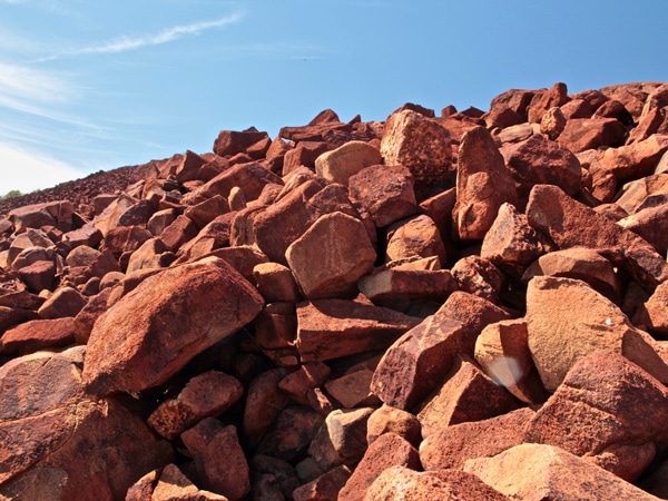
Walker tells me this as we walk together along a red dirt track just out of Karratha, 1500 kilometres north of Perth, to what he describes as the birthplace of the songlines. The undulating tumbles of iron-rich boulders found here on Murujuga (Burrup Peninsula) are best known for the staggering amount of art engraved onto their ancient rock faces.
A count of one million pieces makes it the largest concentration of petroglyphs in the world. But it’s what they point to that interests this custodian. According to him, a songline superhighway starts here.
Like point zero in a capital city, Walker says the Burrup, as it’s commonly known, marks the origin of many songlines. Some stretch across the nation, as far as Alice Springs, Cape York and even Tasmania.
“A lot of the east coast Aboriginal people have lost connection with their songlines, but when they find them and they follow them back, they trace to here – the Burrup," he says. “People come from all over to see the origins of the songlines."
“Songlines are like historical events captured in a few different ways, through storytelling, rock art, songs and dance, and in the landmarks themselves."
The history of the ancient rocks
As I get my head around the significance of this gently spoken truth, we stop and quieten. Walker breaks the silence, calling out in language; he’s greeting the spirits so that we may pass safely. Here at Ngajarli (Deep Gorge) within Murujuga National Park (see breakout box), at least 10,000 rock engravings have been counted.
They’re initially hard to spot – like looking for koalas in eucalyptus limbs – but once you get your eye in, chiselled artworks of animals, fish, footprints, symbols and people are everywhere.
Age estimates vary, but it’s believed some 30,000 to 50,000 years’ worth of stories are told in those weathered rock faces. Many artworks date back to before the last Ice Age, inscribing history like an above-earth time capsule. Over that period, the site has gone from being 100 kilometres inland from the coast, to being encircled by water.
The engravings tell this story via images of sea creatures that were only present in the area after ice melted and seas rose. As I marvel, Walker points out depictions of long-extinct megafauna, such as a three-metre-tall kangaroo.
“These creatures had big thick tails and they were spotty like a giraffe," Walker says. “They went extinct 30,000 years ago, so the rock art is, at a minimum, that old." It’s compelling evidence of the time these rocks have seen pass.
There have been decades’ worth of calls for protection, not least because the Burrup sits in the lee of big mining sites. For conservationists and traditional owners, the Holy Grail is UNESCO World Heritage status, something the WA state and federal governments moved to apply for in January last year. If successful, Murujuga will become one of only two Australian sites listed for their Indigenous cultural significance.
Murujuga means ‘hip bone sticking out’, an apt description of the scenery, and arguably more appropriate than Burrup, the surname of an English bank clerk who was killed in the nearby town of Roebourne in 1885.
Walker is keen to educate people about his ancestry in order to protect what’s here. He estimates his family has lived here for over 2500 generations, yet that’s not a patch on the cinnamon-hued landscape. “These rocks are over 3.5 billion years old and they’re some of the hardest stones on Earth," says Walker. “When I tell Europeans these ages, they just can’t comprehend them."
Stories behind the songlines
We sit in the shade as he shares stories of creation beings killing bats with a boomerang, their plummeting bodies creating the region’s rock-pile hills. The flying fox songlines lead to Millstream Chichester National Park, where more engravings lie, and continue all the way to Queensland’s northern tip.
Meanwhile, the well-known Seven Sisters Dreaming story traces a songline that originates on one of the Dampier Archipelago’s islands and finishes at the Three Sisters in NSW’s Blue Mountains. He tells me of songs that are sung only at night, with not even the light of a fire, because the dances can’t be seen by the uninitiated.
Very few of the songlines have been recorded, with knowledge instead handed down orally. Walker encourages my curiosity, sharing so openly that after only a day, I feel like family.
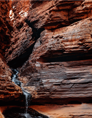
I run my hand over the undulations in Hancock Gorge, and fine iron rust rubs off on my fingertips. Although the dawn air is cold, the rock feels warm, as though it emanates life.
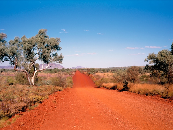
It’s fascinating to learn that some songlines have evolved into modern-day roads, such as the stretch of Highway 1 between Perth and Adelaide, as well as the section linking Darwin and the Kimberley. I set off on my own songline, to Onslow, 300 kilometres south-west of Karratha, though the tunes I’m humming don’t give me any directional clues.
Onslow is one of Pilbara’s oldest towns and it too lies in the shadow of a natural gas mine that’s so big, it took seven years to build. The benefits of having deep pocketed, global resource companies on the doorstep are seen in the 900 permanent residents’ flash hospital, municipal pool and manicured picnic areas.
But there’s more to it. A town tour, led by visitor centre manager Jan Bevan, reveals a former wartime fuel tank that harbours an internal wall gallery of Disney drawings.
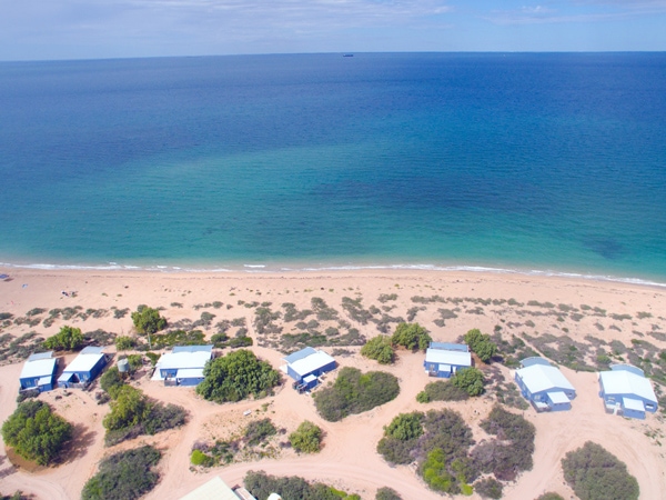
Like a pop culture fresco, the pictures – drawn in the ’60s by a creative German family – rise several metres high. We step back out into piercing light and head to the Onslow Beach Resort, which feels rather Port Douglas with its yawning front bar windows, sun umbrellas and lush lawn facing the ocean.
Need tips, more detail or itinerary ideas tailored to you? Ask AT.
AI Prompt
The Mackerel Islands
From here I depart for the Mackerel Islands, a cluster of isles and atolls that lie 22 kilometres off the coast. Aboriginal people followed songlines here until about 8000 years ago, when the landforms were separated from the mainland.
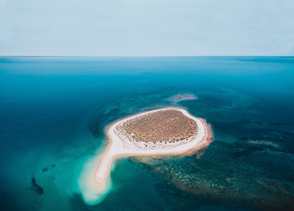
Nowadays, the islands are reached via boat or light aircraft. Only two islands offer accommodation; I stay on Thevenard, home to 13 seriously remote holiday villas. Before sighting land, a bank of gas storage tanks loom into view, looking like overweight grain silos.

Big miner Chevron also uses the island as a base during the off season, before it’s returned to leisure seekers and keen fisherfolk. There’s a distinct off-grid feel and while those tanks are impossible to ignore, they fade from consciousness as I meet other holidaymakers on the beach, hauling hefty arm-length fish from their boat.
With Chevron currently undertaking a decommissioning project, removing the tanks and revegetating the land, future guests will enjoy the island as it once was. I snorkel over coral and clusters of iridescent tropical fish, and by sundown drive to the far end of the island to where exposed reef gurgles and pops as sealife scrambles to the receding water.
At mealtimes, the seriously talented chef sends dishes to my ocean-facing cabin, couriered by ute, though since COVID-19, the island has switched largely to self-catering.
Karijini National Park
Back on the mainland, I drive towards Karijini National Park and wonder again about the songlines. They can run for hundreds, even thousands of kilometres, roaming through the country of countless language groups. The Warlu Way, which leads to Karijini, follows a songline created by a Dreamtime sea serpent, or warlu. As my tyres turn, I imagine the ancient path shimmering beneath the bitumen.

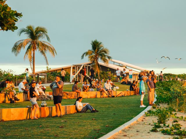
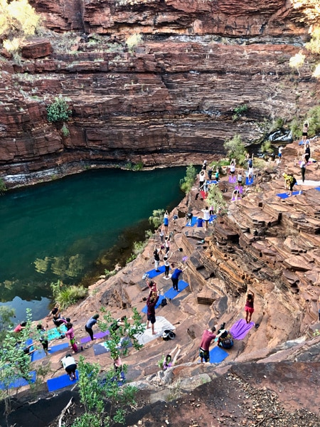
Karijini is a sacred place for the Banyjima, Yinhawangka and Kurrama people, frequented still by elders and youngsters alike. Deep connections are shared each year through the Karijini Experience, an Aboriginal cultural and food-driven festival held over Easter. Seen as an act of reconciliation, it involves 16 Indigenous language groups and 2000 visitors who might listen to an Aboriginal opera singer in a gorge amphitheatre, hear rock’n’roll anthems sung in dialect and feast on green ants and kangaroo cooked by a WA chef who staged at Noma.
A much-loved Banyjima elder named Maitland Parker leads memorable bush walks. He points out nectar-rich flowers used to make cordial and bark that, when burnt, is rubbed on the skin to act as sunscreen. Then, in the same matter-of-fact style, he tells us about being forced to give up his Aboriginal heritage to get the basic rights afforded by Australian citizenship, something that went on until the late 1960s.
After teaching us an After teaching us an Banyjima greeting, the former park ranger goes further back, to when explorers described his country as a land with nothing on it. “Our culture here is the oldest in the world, so what’s this terra nullius business?" he asks, managing to treat the offence with lightness, making the truth of it penetrate deeper.
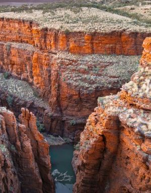
Snowy-haired Parker says he’ll come to the Karijini Experience until the end of his days, and I can see why. Beyond the inclusive festivities, the place itself has an affecting energy, similar to the presence sensed at Uluru. An oasis in the West Australian desert, it harbours 2.5-billion-year-old rocks that time has cut into meandering gorges. Flat, jutting layers are stacked like French crepes in alternating hues of cinnamon, paprika and cumin, their surfaces polished by wind and cascading water.
I run my hand over the undulations in Hancock Gorge, and fine iron rust rubs off on my fingertips. Although the dawn air is cold, the rock feels warm, as though it emanates life. I feel connected to it, awed by it and slightly frightened by the geological grandeur. Slipping through narrow gaps and spider-scrambling along rugged terraces, I’m grateful that this place threaded with songlines will welcome wanderers like me for thousands of years to come.
Take a boardwalk back in time
Half an hour’s drive from Karratha and covering nearly 5000 hectares of the Burrup Peninsula is Murujuga National Park, where ancient rock engravings that help make up the largest concentration of petroglyphs in the world are etched onto a landscape of steep rocky outcrops, narrow valleys, sea cliffs, sandy shores and mangroves.
And thanks to the opening of the $1.3 million Ngajarli Trail in August last year, viewing this astonishing open-air art gallery is now easier than ever for travellers.
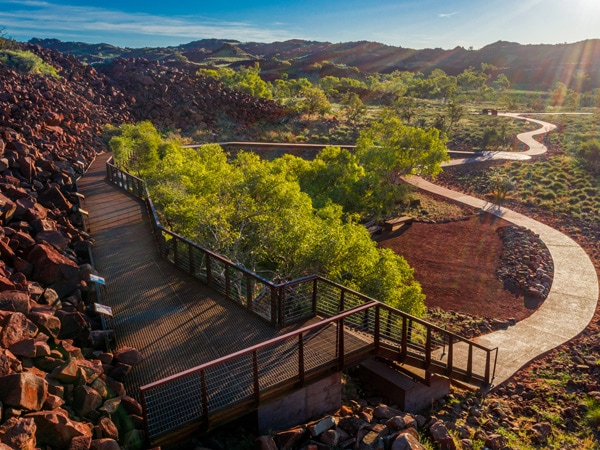
Developed with guidance and advice from the Murujuga Park Council and Circle of Elders (the park is owned by the Murujuga Aboriginal Corporation, which represents the five Traditional Custodian groups of the area – Ngarluma, Yindjibarndi, Yaburara, Mardudhunera and Woon-goott-oo – collectively known as Ngarda-Ngarli), the new trail will help the rock art and its stories become more accessible to the community, while also protecting ancient sites.
The first infrastructure of its type to be built in the national park – which became Australia’s 100th when it was gazetted in 2013 – the 700-metre universal boardwalk running from Ngajarli (Deep Gorge) replaces a rough walking route, following the edge of natural rock piles and providing visitors with ample viewing platforms and interpretative signage that details the cultural importance of the site along the way.

Not only will you spy petroglyphs that depict humans and animals including extinct megafauna and even the thylacine (Tasmanian tiger), but also grinding stones and shell middens – which provide tangible links and deep connection for the Ngarda-Ngarli between the events and people of the past and their beliefs today. parks.dpaw.wa.gov.au
Weekly travel news, experiences
insider tips, offers, and more.
A traveller’s checklist
Getting there
Fly to Perth and then onto Paraburdoo or Karratha with Qantas, pick up a hire car and spin those wheels. To recreate the trip in this article, go Paraburdoo-Karijini-Onslow-Mackerel Islands-Karratha-Burrup Peninsula, or vice versa.
Staying there
Stay in one of 73 luxury apartments at The Ranges Karratha, set within landscaped gardens with a resort-style pool. therangeskarratha.com.au
Glamp in the heart of the national park at Karijini Eco Retreat. karijiniecoretreat.com.au
Enjoy a coastal outback stay at Onslow Beach Resort before being cast away to a beachfront cabin at its sister property in the nearby Mackerel Islands. onslowbeachresort.com.au
Ninety kilometres west of Paraburdoo, Cheela Plains Station Stay provides travellers in the Pilbara with rustic outback comfort. cheelaplains.com.au
Exploring there
The Aboriginal-focused Karijini Experience runs for five days each April (6-10 April 2021). Between events, self-drive to as many gorges as you can, prioritising a climb into Hancock Gorge. karijiniexperience.com
Canyoning fans should join West Oz Active Adventure Tours based at Karijini Eco Retreat. westozactive.com.au
Understand the age and Aboriginal significance of the Burrup Peninsula on a tour with Clinton Walker of Ngurrangga Tours. ngurrangga.com.au
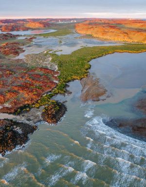
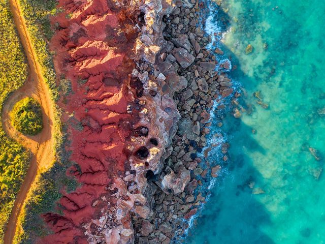
Get an aerial perspective of Karratha’s coastline and the Burrup Peninsula with a Helispirit helicopter tour. helispirit.com.au
Pre-book the quirky Hidden Treasures Onslow Tour with Onslow Visitor Centre’s Jan Bevan. facebook.com/onslowvisitorscentre
Hot tips
4WD vehicles are recommended, but you can manage – even in Karijini – with a 2WD, weather depending. There are no petrol stations within Karijini so you must bring enough fuel for travel within the park, as well as to it (get supplies at Tom Price, 80 kilometres west). Optus is the only provider that works in Karijini, whereas Telstra is best elsewhere.
Want to see more stories from Australian Traveller in your Google search results?
- Click here to set Australian Traveller as a preferred source.
- Tick the box next to "Australian Traveller". That's it.