Driving the Overlander’s Way & Savannah Way

hero media
Australian Traveller looks at the Overlander’s and Savannah Way, one of Australia’s 10 Greatest Outback Journeys.

A quick farewell glance in the rear view mirror when leaving Townsville and before you know it you’ve begun your Overland and Savannah Way adventures – combining two of Australia’s great outback trails into a single 2235km journey across the northeastern corner of the continent from Townsville to the NT border via iconic outback Mt Isa, before looping back east to Cairns.


Heading southwest along the Flinders Highway (The Overlander’s Way) to Hughenden, you can test your singing or sportsmanship skills at the old gold mining town of Charters Towers – once Queensland’s second-largest city, now host to Australia’s largest amateur cricket carnival and music quest. Pause at the Burra Range lookout on your way through White Mountains National Park. At the strategically placed Torrens Creek you can learn about the WWII Coral Sea battle when the town became a supply dump for explosives, which was accidentally blown up by US soldiers.


After a quick stop at Qld’s Prairie Hotel to ease the hunger pangs, you’ll have made it to Hughenden, where you can take a prehistoric walk through the Flinders Discovery Centre or snap a photo with Mutt, the life-sized Muttaburrasaurus model. Hit up a 4WD track and finish the day off with a sunset at MountWalkeror the stunning Porcupine Gorge.

You’ll need all your rest, though, because your next major stop will be Mount Isa – but on the way be sure to drop in on Richmond (for some fossil fossicking), Julia Creek with its famous Dirt ‘n’ Dust Festival each April, and Cloncurry – home of the Royal Flying Doctor Service with its memorial to founder John Flynn.


While inMountIsa, raise your Akubras to the largest rodeo in the Southern Hemisphere. One of the largest producers of copper ore inAustralia, Isa is considered the Rodeo Capital of Australia and has always been a town renowned for its outback welcome. With 900km clocked on the odometer, you’ve roughly reached the halfway mark in your Overland Savannah adventure, and as Queensland Rail so aptly puts it: “You’re not a real Aussie till you’ve been to the Isa."


Travelling two hours west along Tojo’s Highway (locals’ nickname) to Camooweal, just 12km shy of the NT border, this once lively drovers’ centre is Queensland’s most westerly town. Skim the border as you head north to Burketown via Gregory Downs, where you can rent a canoe year-round and spend the night camping next to the river.

Some 120km later, you’ll have finally joined up with the legendary nation-spanning Savannah Way– just before rolling into Burketown, the self-titled Barramundi Capital of Australia. Outside its annual fishing championships, this small town on the Albert River with its lonely salt plains is a peaceful divider between the wetlands and the magnificent Savannah grasslands.


Heading east to Normanton (winner ofTidyTown’s Friendliest Town 2007), you’re now deep in Savannah Gulf territory. And, after posing alongside Krys the Savannah King, Normanton’s statuesque 8.63m tribute to the largest estuarine croc ever captured, it’s all aboard the historic Gulflander train for 152km of scenic bliss. (It eventually returns for those who left their car in Normanton.)


If you’re driving the whole way, stop in for some wetland scenery and wildlife at Karumba, a primary player in the Gulf’s prawning and fishing industry, then back on course for your lunch date in Croydon, another ex-goldmining town. Once pastGeorgetown, a booming goldmining town in the 1800s, you’ll be delighted to reachMountSurprise, where you can take a family friendly half-day gem fields tour.


With souvenirs and memories well in hand, you’re now on your final leg toCairns. Spend a night camping in theUndaraVolcanicNational Parkand explore by guided tour one of the longest lava cave tubes in the world. Then, once on the home stretch, take a dip in the Innot Hot Springs, just west of the Atherton Tablelands, and finish your outback adventure in sunnyCairns.


Who got there first? // Matthew Flinders first charted the Gulf Coast in 1802, but it was Captain J Lort Stokes who retraced his steps and discovered the Albert River, sailing down it and first spotting the grasslands he called the “the plains of promise". Ludwig Leichhardt explored the area next in 1848, 12 years before Burke and Wills. However, it was Frederick Walker and William Landsborough (when searching for Burke and Wills) who opened up the whole Gulf area.


Don’t miss // The astonishing Morning Glory in the Gulf of Carpentaria, a 1000km-long cloud formation that rolls across the sky from Sept-Nov. Best seen from Burketown.


Drive time // Total distance, 2235km. This type of trip has a lot to do and see so there’s no point rushing it. Spend at least a good two to three weeks experiencing everything it has to offer.


Dos + Don’ts

1. Some parts of the Gulf Savannah suffer from lack of road infrastructure, so be particularly careful during monsoonal season.

2. Before bushwalking, especially in remote areas like the White Mountains NP, tell someone where you’re going, when and your expected return.

3. Remember to report any sealed roads on your travels that you consider to be particularly unroadworthy to the RACQ (www.racq.com.au).

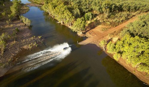
4. 4WDs aren’t invincible, so be careful with any deep creek crossings – if water gets into the air intake, it’s game over for your engine.

5. Invest in a “snatchem strap" for extraction from muddy or boggy roads (if there’s another vehicle nearby, that is).


Accessibility // Most of the roads along the Overland Way and Savannah Way are sealed – and even the un-sealed ones are definitely accessible for a standard vehicle. However, there are some pretty spectacular 4WD tracks that a regular car won’t be able to handle.


Did you know? // Broadly speaking, there are two seasons in this part of Queensland: April to September is dry/winter and October to March is wet/summer.


More info // Visit www.savannahway.com.au for more info on the Savannah Way from Hell’s Gate to Cairns, and www.adventureoutback.com.au  for more info on the Overland Way.


Sidetracks // Overland and Savannah Ways

1. Burke and Wills roadhouse // The site of the explorers’ last northern camp, halfway between Cloncurry and Normanton on the Matilda Hwy.

2. Hell’s Gate // 50km east of the NT border and gateway to the Macassan coast. Explore Aboriginal art and don’t miss the Hell’s Gate Roadhouse, which has everything from food supplies to a limited mechanical workshop.

3. Pungalina Station // For a real outback experience, stay at this eco wilderness Australian outback property 65km north of the Savannah Way (1.5hr flight from Mt Isa). 500,000 hectares of rugged gorges, barramundi fishing and bird watching. With safari camps, flying and 4WDs, it’s an outback adventurer’s delight. www.pungalinasafaris.com.au

4. Boodjamulla (Lawn Hill) National Park // 282,000 hectare park around 400km northwest of Mt Isa.

5. O’Brien’s Creek // Grab a fossicking permit and geo tool before heading off to hunt for topaz in O’Brien’s Creek, 40min north of Mt Surprise.

Need tips, more detail or itinerary ideas tailored to you? Ask AT.

AI Prompt

Want to see more stories from Australian Traveller in your Google search results?

  1. Click here to set Australian Traveller as a preferred source.
  2. Tick the box next to "Australian Traveller". That's it.
Australian Traveller

Australian Traveller

View profile and articles
From coast to bush: these are Gippsland’s best hikes

    Michael Turtle Michael Turtle

    Video credit: Tourism Australia

    From coast to mountains, hiking in Gippsland offers a stunning array of landscapes, with trails that take you deep into the region’s heritage.

    I step out onto the sand and it cries out underfoot. Kweek! I take another step and there’s another little yelp. Screet! Picking up the pace, the sounds follow me like my shadow, all the way down to the water. It’s obvious how this spot got its name – Squeaky Beach – from the rounded grains of quartz that make the distinctive sounds under pressure.

    For many, Wilsons Promontory National Park is the gateway to Gippsland, and the best way to explore it is by walking its network of hiking trails, from coastal gems such as Squeaky Beach through to the bushland, among the wildlife. But it’s still just a taste of what you’ll find on foot in the region.

    Venture a bit further into Gippsland and you’ll discover the lakes, the rainforest, and the alpine peaks, each changing with the season and offering summer strolls or winter walks. Just like that squeaky sand, each step along these trails has something to tell you: perhaps a story about an ancient spirit or a pioneering search for fortune.

    The best coastal hikes in Gippsland

    sunset at Wilsons Promontory National Park
    Wilsons Promontory National Park is a sprawling wilderness with many coastal bushland trails. (Image: Mark Watson)

    Wilsons Promontory National Park (or ‘The Prom’, as you’ll end up calling it) is an easy three-hour drive from Melbourne, but you might ditch the car when you arrive, with much of the park’s 50,000 hectares accessible only by foot. From the inky water of Tidal River (dyed dark purple by abundant tea trees), I like the easy walks along the coast, among lichen-laden granite boulders, to golden beaches and bays.

    a couple on Mount Oberon
    Panoramic views from the summit of Mount Oberon. (Image: Everyday Nicky)

    The trail to the panoramic views at the summit of Mount Oberon is a bit harder, up steep timber and granite steps, but it’s a popular 6.8-kilometre return. The more remote hikes are found through the open banksia and stringybark woodland of the park’s north, or along the multi-day Southern Circuit, which ranges from about 35 to 52 kilometres, with sunrises and sunsets, kangaroos and cockatoos, and maybe even whales.

    a golden sand beach at Wilsons Promontory National Park
    Walk ‘The Prom’s’ golden sand beaches. (Image: Tourism Australia/Time Out Australia)

    You might also see whales on the George Bass Coastal Walk, even closer to Melbourne on the western edge of Gippsland. This dramatic seven-kilometre trail along the clifftops takes in sweeping views of the wild ocean, occasionally dipping down from grassy green hills to coastal gullies and a secluded beach. It also now links into the Bass Coast Rail Trail for an extra 14 kilometres.

    the George Bass Coastal Walk
    George Bass Coastal Walk trails for seven kilometres along clifftops. (Image: Visit Victoria/Time Out Australia)

    Over at the eastern edge of Gippsland, in Croajingolong National Park, you can wander along the lakeshores beneath koalas and around goannas (I keep my distance since one chased me here!). For those who are even more adventurous, the park is also the starting point for the 100-kilometre Wilderness Coast Walk, usually done over seven days.

    the Croajingolong National Park, Gippsland
    Wander along the lakeshores in Croajingolong National Park. (Image: Tourism Australia)

    The best bush hikes in Gippsland

    the Baw Baw National Park
    The alpine heath of Baw Baw National Park. (Image: Everyday Nicky)

    Deep in the Long Tunnel Extended Gold Mine at Walhalla, mining guide Richard tells me how this small town in the mountains east of Melbourne boomed when prospectors found gold here in 1862. These days, you’ll find most of the town’s treasure – its heritage – above ground, with the Walhalla Tramline Walk a wonderful way to explore it.

    Just seven kilometres long, the walk takes you through decades of Gold Rush history, following the original rail trail from lush bushland to the mining sites, and through the charming village of just 20 residents with its wooden cottages and old shopfronts adorned with turn-of-the-century advertising posters. Blazing a trail where trailblazers once opened up the region, this is also the starting point for the 650-kilometre Australian Alps Walking Track.

    Nearby, Baw Baw National Park has walks through gnarled snow gums and alpine heaths that show off the colourful wildflowers in summer and the pristine carpet of white in winter. Several trails are perfect for snowshoes, including a 45-minute route from St Gwinear up to vast views across the Latrobe Valley.

    Further up into the mountains, the Toorongo and Amphitheatre Falls Loop Walk is an easy 2.2-kilometre path that serenades you with the sound of flowing water as you pass mossy rocks and tree ferns en route to two sets of waterfalls cascading over boulders in the remote wilderness.

    The best cultural hikes in Gippsland

    the Mitchell River National Park, Gippsland
    Hike the Mitchell River National Park. (Image: Parks Victoria/Grace Lewis)

    Across a pool in a natural sandstone amphitheatre, deep within a cave behind a waterfall, it’s said the Nargun has its lair. A fierce creature, half human and half stone, that abducts children and can’t be harmed by boomerangs or spears, the story of the Nargun has been told around the campfires of the local Gunaikurnai people for generations.

    As a culturally significant place for women, hikers are asked not to go into the Den of Nargun, but a 3.4-kilometre loop walk leads you through a rainforest gully to the entrance where you can feel the powerful atmosphere here in Mitchell River National Park, along Victoria’s largest remaining wild and free-flowing waterway.

    the bee-eaters at Mitchell River National Park
    Bee-eaters at Mitchell River National Park. (Image: Parks Victoria/Grace Lewis)

    The Den of Nargun is part of the Bataluk Cultural Trail, a series of important traditional Gunaikurnai sites through central Gippsland. Another location is Victoria’s largest cave system, Buchan Caves Reserve, with trails to important archaeological sites of human artefacts up to 18,000 years old. The FJ Wilson Interpreted Walk includes the naturally sculpted white limestone steps of the 400-metre-long Federal Cave, while the Granite Pools Walk goes among tall timber and moss-covered gullies.

    the ancient rainforest of Tarra-Bulga National Park
    The ancient rainforest of Tarra-Bulga National Park. (Image: Josie Withers)

    Also important to the Gunaikurnai people is Tarra-Bulga National Park, known for its ancient myrtle beeches and enormous mountain ash trees. Just 40 minutes return, the Tarra Valley Rainforest Walk offers a taste of this verdant landscape, while the Grand Strzelecki Track takes you deep into the lost world of forest giants on an epic 100-kilometre trail rich with tradition.

    A traveller’s checklist

    Staying there

    the WildernessRetreats in The Prom
    Wilderness Retreats in The Prom. (Image: Christian Pearson)

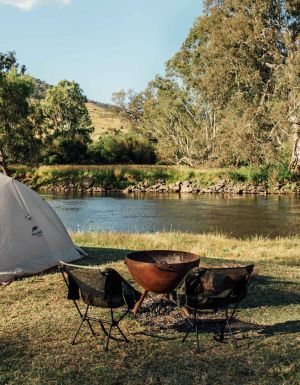
    Wilderness Retreats in Wilsons Promontory offers glamping-style tents with luxurious queen beds. Star Hotel is a reconstruction of a Gold Rush-era hotel from 1863 in the heart of heritage Walhalla. Caves House is a historic three-bedroom house with views over the Buchan River.

    Eating there

    the Carrajung Estate, Gippsland
    Enjoy a post-hike lunch at Carrajung Estate. (Image: Everyday Nicky)

    Kilcunda General Store serves great coffee and meals of local produce at the George Bass Coastal Walk. Alpine Trout Farm is located near Toorongo Falls in Noojee. Fish for your own lunch and barbecue it with the provided cookware.

    Carrajung Estate is a short drive from Tarra-Bulga National Park. The winery’s restaurant offers a seasonal menu of regional ingredients and you can stay at The Lodge.

    a seafood feast at Carrajung Estate, Gippsland
    The table is set for a seafood feast at the estate.

    Video credit: Tourism Australia