How to travel the Australian Outback

hero media
How far do you have to travel into Australia’s outback, before you’re actually heading back in? Peter Robinson ventures passed Broken Hill through Uluru and Alice Springs to the Kimberley and back to find out exactly where the Great Australian Outback begins . . . .

There’s been a 4WD sitting in my driveway for the past 20 years. Not fulltime, you understand; it gets driven often, being the only vehicle I own.


And, yep, it gets driven around town a fair bit, which means I get my fair share of grief from doubting do-gooders who view any large-base vehicle in a metro setting as the ultimate in environmental terrorism.


But the fact is, I’ve chalked up tens of thousands of kilometres in the outback. And that’s where a big, capable 4WD comes into its own.


In 1813, when Gregory Blaxland struck out eastward from Sydney to forge a track through the Blue Mountains, it was a great adventure into the unknown.


Not that he probably thought that at the time, given the hardship involved. It must have been much the same for any of the other pioneering Europeans who made first forays east to west, south to north, edge to baking centre – the likes of Charles Sturt, John McDouall Stuart, Burke and Wills.


“It’s not actually delineated on any map, although many books refer to the outback nonchalantly as if the reader knows just where it is."


Now, in air-conditioned luxury, we can take a smooth, black ribbon towards the vast interior of Australia and find places where Google Earth and GPS units give way to good old-fashioned map reading. But first, it’s a huge country out there, and most of it’s outback – so let’s have a look at exactly where you’re going.


It’s not actually delineated on any map, although many books refer to the outback nonchalantly as if the reader knows just where it is. International tourists have heard of it and come to visit only to find a week in a hire car doesn’t cut it.


“…draw an imaginary line 200km inland starting from Adelaide, all the way around the east coast to Cairns, and call anything north and west of that line The Outback."


It’s been defined by various authoritarian tomes as “remote, sparsely inhabited back country", and “remote inland districts or back country of Australia." But these are no help at all.


Neither is the old saying that the outback consists of “anything out the back o’ Bourke." Beyond the Black Stump? Perhaps. But no two people can agree on which stump near what town is the real deal.


As a rough guide, here’s what AT reckons: draw an imaginary line 200km inland starting from Adelaide, all the way around the east coast to Cairns, and call anything north and west of that line The Outback.


Apart from a few larger towns, that’s a pretty good stretch of country to call outback (with apologies to Perth and Darwin) and there’s hardly anyone there (more apologies to Perth and Darwin and anyone stuck in-between).


For a final word on the matter, we asked long-time AT supporter and former Deputy PM the Honourable Tim Fischer to give us his first impressions of exactly where the outback might be.


“…once you’ve exhausted two tanks of fuel you’re in back country, where the population is sparse and mobile phone coverage is even worse. You’ll be allocated a batch of flies, which will enjoy your company and your food."


“Everything 50km or more north of the Sydney to Perth Transcontinental Railway Line," he asserts, “that’s also 100km or more west of the Newell Highway and 100km west of the NSW and Queensland east Pacific Coast. Alternatively, excluding all of Victoria and Tasmania, the ‘Great Outback’ is, by rule of thumb, everything north of a line from Sydney to Spalding, Port Lincoln to Esperance via the coastline of the Bight, and thence to Perth, but more than 100km inland from the Queensland east coast, 200km inland from the NSW east coast, and Cervantes on the northwest coast of WA. And I prefer that first one." Glad we got that settled.


On the practical side, once you’ve exhausted two tanks of fuel you’re in back country, where the population is sparse and mobile phone coverage is even worse.


You’ll be allocated a batch of flies, which will enjoy your company and your food. Locusts will hitch a free ride in your radiator, and corrugations will rattle your fillings loose.


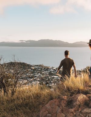
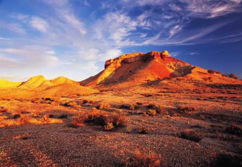
Stand just about anywhere in the outback, wave away the flies and look down at your feet. Discard any notions that this is the “dead" heart of Australia; though it’s a harsh environment amid the spinifex and saltbush, a surprisingly dynamic and resilient microcosm of life survives.
A downpour in the outback can produce – literally overnight – an ephemeral carpet of colourful wildflowers midst stone and red sand. In the same timeframe, it also produces impassable roads.


And, if Cooper Creek floods into Lake Eyre, another miracle occurs: vast saltpans become an inland sea teeming with myriad aquatic and bird life until the cycle begins all over again. With luck you might get a once-in-a-lifetime sight – a waterfall on Uluru, or snow on St Mary’s peak in the Flinders Ranges. Or simply a cold beer in a remote country pub.

Need tips, more detail or itinerary ideas tailored to you? Ask AT.

AI Prompt

Australian Traveller

Australian Traveller

View profile and articles

From coast to bush: these are Gippsland’s best hikes

    Michael Turtle Michael Turtle

    Video credit: Tourism Australia

    From coast to mountains, hiking in Gippsland offers a stunning array of landscapes, with trails that take you deep into the region’s heritage.

    I step out onto the sand and it cries out underfoot. Kweek! I take another step and there’s another little yelp. Screet! Picking up the pace, the sounds follow me like my shadow, all the way down to the water. It’s obvious how this spot got its name – Squeaky Beach – from the rounded grains of quartz that make the distinctive sounds under pressure.

    For many, Wilsons Promontory National Park is the gateway to Gippsland, and the best way to explore it is by walking its network of hiking trails, from coastal gems such as Squeaky Beach through to the bushland, among the wildlife. But it’s still just a taste of what you’ll find on foot in the region.

    Venture a bit further into Gippsland and you’ll discover the lakes, the rainforest, and the alpine peaks, each changing with the season and offering summer strolls or winter walks. Just like that squeaky sand, each step along these trails has something to tell you: perhaps a story about an ancient spirit or a pioneering search for fortune.

    The best coastal hikes in Gippsland

    sunset at Wilsons Promontory National Park
    Wilsons Promontory National Park is a sprawling wilderness with many coastal bushland trails. (Image: Mark Watson)

    Wilsons Promontory National Park (or ‘The Prom’, as you’ll end up calling it) is an easy three-hour drive from Melbourne, but you might ditch the car when you arrive, with much of the park’s 50,000 hectares accessible only by foot. From the inky water of Tidal River (dyed dark purple by abundant tea trees), I like the easy walks along the coast, among lichen-laden granite boulders, to golden beaches and bays.

    a couple on Mount Oberon
    Panoramic views from the summit of Mount Oberon. (Image: Everyday Nicky)

    The trail to the panoramic views at the summit of Mount Oberon is a bit harder, up steep timber and granite steps, but it’s a popular 6.8-kilometre return. The more remote hikes are found through the open banksia and stringybark woodland of the park’s north, or along the multi-day Southern Circuit, which ranges from about 35 to 52 kilometres, with sunrises and sunsets, kangaroos and cockatoos, and maybe even whales.

    a golden sand beach at Wilsons Promontory National Park
    Walk ‘The Prom’s’ golden sand beaches. (Image: Tourism Australia/Time Out Australia)

    You might also see whales on the George Bass Coastal Walk, even closer to Melbourne on the western edge of Gippsland. This dramatic seven-kilometre trail along the clifftops takes in sweeping views of the wild ocean, occasionally dipping down from grassy green hills to coastal gullies and a secluded beach. It also now links into the Bass Coast Rail Trail for an extra 14 kilometres.

    the George Bass Coastal Walk
    George Bass Coastal Walk trails for seven kilometres along clifftops. (Image: Visit Victoria/Time Out Australia)

    Over at the eastern edge of Gippsland, in Croajingolong National Park, you can wander along the lakeshores beneath koalas and around goannas (I keep my distance since one chased me here!). For those who are even more adventurous, the park is also the starting point for the 100-kilometre Wilderness Coast Walk, usually done over seven days.

    the Croajingolong National Park, Gippsland
    Wander along the lakeshores in Croajingolong National Park. (Image: Tourism Australia)

    The best bush hikes in Gippsland

    the Baw Baw National Park
    The alpine heath of Baw Baw National Park. (Image: Everyday Nicky)

    Deep in the Long Tunnel Extended Gold Mine at Walhalla, mining guide Richard tells me how this small town in the mountains east of Melbourne boomed when prospectors found gold here in 1862. These days, you’ll find most of the town’s treasure – its heritage – above ground, with the Walhalla Tramline Walk a wonderful way to explore it.

    Just seven kilometres long, the walk takes you through decades of Gold Rush history, following the original rail trail from lush bushland to the mining sites, and through the charming village of just 20 residents with its wooden cottages and old shopfronts adorned with turn-of-the-century advertising posters. Blazing a trail where trailblazers once opened up the region, this is also the starting point for the 650-kilometre Australian Alps Walking Track.

    Nearby, Baw Baw National Park has walks through gnarled snow gums and alpine heaths that show off the colourful wildflowers in summer and the pristine carpet of white in winter. Several trails are perfect for snowshoes, including a 45-minute route from St Gwinear up to vast views across the Latrobe Valley.

    Further up into the mountains, the Toorongo and Amphitheatre Falls Loop Walk is an easy 2.2-kilometre path that serenades you with the sound of flowing water as you pass mossy rocks and tree ferns en route to two sets of waterfalls cascading over boulders in the remote wilderness.

    The best cultural hikes in Gippsland

    the Mitchell River National Park, Gippsland
    Hike the Mitchell River National Park. (Image: Parks Victoria/Grace Lewis)

    Across a pool in a natural sandstone amphitheatre, deep within a cave behind a waterfall, it’s said the Nargun has its lair. A fierce creature, half human and half stone, that abducts children and can’t be harmed by boomerangs or spears, the story of the Nargun has been told around the campfires of the local Gunaikurnai people for generations.

    As a culturally significant place for women, hikers are asked not to go into the Den of Nargun, but a 3.4-kilometre loop walk leads you through a rainforest gully to the entrance where you can feel the powerful atmosphere here in Mitchell River National Park, along Victoria’s largest remaining wild and free-flowing waterway.

    the bee-eaters at Mitchell River National Park
    Bee-eaters at Mitchell River National Park. (Image: Parks Victoria/Grace Lewis)

    The Den of Nargun is part of the Bataluk Cultural Trail, a series of important traditional Gunaikurnai sites through central Gippsland. Another location is Victoria’s largest cave system, Buchan Caves Reserve, with trails to important archaeological sites of human artefacts up to 18,000 years old. The FJ Wilson Interpreted Walk includes the naturally sculpted white limestone steps of the 400-metre-long Federal Cave, while the Granite Pools Walk goes among tall timber and moss-covered gullies.

    the ancient rainforest of Tarra-Bulga National Park
    The ancient rainforest of Tarra-Bulga National Park. (Image: Josie Withers)

    Also important to the Gunaikurnai people is Tarra-Bulga National Park, known for its ancient myrtle beeches and enormous mountain ash trees. Just 40 minutes return, the Tarra Valley Rainforest Walk offers a taste of this verdant landscape, while the Grand Strzelecki Track takes you deep into the lost world of forest giants on an epic 100-kilometre trail rich with tradition.

    A traveller’s checklist

    Staying there

    the WildernessRetreats in The Prom
    Wilderness Retreats in The Prom. (Image: Christian Pearson)

    Wilderness Retreats in Wilsons Promontory offers glamping-style tents with luxurious queen beds. Star Hotel is a reconstruction of a Gold Rush-era hotel from 1863 in the heart of heritage Walhalla. Caves House is a historic three-bedroom house with views over the Buchan River.

    Eating there

    the Carrajung Estate, Gippsland
    Enjoy a post-hike lunch at Carrajung Estate. (Image: Everyday Nicky)

    Kilcunda General Store serves great coffee and meals of local produce at the George Bass Coastal Walk. Alpine Trout Farm is located near Toorongo Falls in Noojee. Fish for your own lunch and barbecue it with the provided cookware.

    Carrajung Estate is a short drive from Tarra-Bulga National Park. The winery’s restaurant offers a seasonal menu of regional ingredients and you can stay at The Lodge.

    a seafood feast at Carrajung Estate, Gippsland
    The table is set for a seafood feast at the estate.

    Video credit: Tourism Australia