The Australian Alps Walking Track

hero media
The fourth of Australian Traveller’s epic bushwalks, the Australian Alps Walking Track is also the highest.

Foremost is the walk from Mt Howitt to the Viking (four days), revealing some of the most rugged and spectacular areas in the High Country. The type of terrain is betrayed by some of the feature names: Mt Buggery, Mt Despair, Horrible Gap and the Terrible Hollow.


The mountain lover’s long-distance trail, the Australian Alps Walking Track (AAWT) rolls up, over and through the High Country between Walhalla, in Victoria’s Gippsland region, and Canberra’s edge.


Though it’s the closest of the trails to Sydney and Melbourne, it’s also conversely the most isolated and demanding, requiring detailed preparation and up to six weeks in changeable mountain conditions.


Throughout its 680km length, the AAWT never once passes through a town – the nearest thing it sees to a settlement is the Mt Hotham resort (it also passes within a few klicks of Thredbo).


For this reason it’s a logistical exercise as much as a physical one, requiring a number of food drops (usually hidden in the bush) to be organised ahead of your departure.


First mooted as a walking trail in the late 1960s, the original plan was for a Victorian track only, beginning in Walhalla and ending at Tom Groggin on the NSW border.


By 1976 this trail was complete, and it wasn’t until the 1990s that the extension through NSW and into the ACT was added.


Though it’s unquestionably spectacular, the AAWT is also an imperfect trail, running close to some of the country’s outstanding peaks, including Mts Feathertop, Bogong, Kosciuszko, Townsend and Tate, but not over them.


Fortunately, it’s a simple task to remedy this. A day can be spent walking along Razorback Ridge from Hotham to Feathertop, while Cleve Cole Hut, on the AAWT, is little more than an hour’s walk from Bogong.


At Rawson Pass, beneath Kosciuszko, the AAWT makes an unusual dogleg, turning away from the peaks and following the sealed Charlotte Pass road back to Smiggin Holes.


Far better is to continue along the Main Range from Rawson Pass, climbing over Australia’s highest peaks and rejoining the AAWT at Whites River Hut.


Trail highlights are many, though two or three stages stand out.


Foremost is the walk from Mt Howitt to the Viking (four days), revealing some of the most rugged and spectacular areas in the High Country. The type of terrain is betrayed by some of the feature names: Mt Buggery, Mt Despair, Horrible Gap and the Terrible Hollow.


Begin near Macalister Springs, off Howitt Road, joining the AAWT just below Mt Howitt and inching across the narrow Crosscut Saw ridge to Mt Speculation.


After climbing to the summit of Mt Despair the terrain becomes even more difficult, with the track unmarked and difficult to follow.


Atop the Viking, the AAWT turns east towards Barry Saddle, but you can also complete a circuit back to Mt Howitt by descending to the Wonnangatta River and back up the Wonnangatta Spur.


A second section of note is the 76km from Hotham across the Bogong High Plain and Mt Wills to the Omeo Hwy, following snow poles much of the way.


It represents about five days in the company of Victoria’s mountain royalty: great views of Feathertop, a climb to Mt Nelse, a detour to Bogong and, finally, views back to the high plain from Mt Wills.


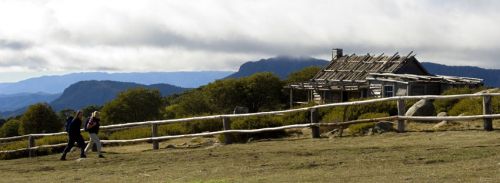
This section also provides a great showcase of mountain cattlemen huts, like Wallace’s Hut on the Bogong High Plain (top).


For a break from mountains, consider the 50km section from the old gold-mining settlement of Kiandra through the Cooleman area of northern Kosciuszko NP.


You’ll have the opportunity to see the Murrumbidgee River in its mountain-stream infancy before climbing over Gurrangorambla Range to one of the High Country’s most unusual features: the porous karst of the Cooleman Plain.


This tussocky plain is hole-punched with caves, most notably at Blue Waterholes, where a series of springs pours to the surface.


Take a detour (and a torch) west along Cave Creek and you’ll find two of the more impressive caves, while the creek itself is most dramatic just downstream from Blue Waterholes, through the limestone Clarke Gorge to a series of waterfalls beyond.

Need tips, more detail or itinerary ideas tailored to you? Ask AT.

AI Prompt

Want to see more stories from Australian Traveller in your Google search results?

  1. Click here to set Australian Traveller as a preferred source.
  2. Tick the box next to "Australian Traveller". That's it.
Australian Traveller

Australian Traveller

View profile and articles
hero media

8 incredible hikes just outside of Melbourne

Just over an hour from Melbourne, spectacular walking and hiking trails encompass ancient landscapes, forested ridgelines and volcanic peaks.

Just a short drive from the city, the urban sprawl gives way to rolling hills, mineral springs, and lush forests that will have you feeling like you’re in the bucolic countryside of France. Encompassing Daylesford, the Macedon Ranges, Castlemaine and the Central Goldfields, this pocket of Victoria is a region where nature, art, and wellness intertwine. Heritage towns hum with creativity, good food and wine, and welcoming locals. While Daylesford hikes, and those nearby, offer the chance to take a pause and reconnect with nature.

1. Hanging Rock Summit Walk

Hanging Rock Summit Walk
Take in views across the Macedon Ranges.

Etched into folklore, few places in Australia carry as much mystique as Hanging Rock. Rising dramatically from the plains near Woodend, this volcanic mamelon offers a beautiful nature walk. The walk begins at a gentle pace, weaving through shaded woodland before it gets a little steeper as the path starts to climb and twist to the summit. From here, you’ll have views that stretch across the Macedon Ranges. The walk is roughly 1.8 kilometres return, but the real reward lies in standing among the weathered boulders, feeling the age and energy of the earth beneath your feet.

2. Macedon Ranges Walking Trail

Macedon Ranges Walking Trail camel's hump lookout
Walk to Camel’s Hump. (Image: Clair Derwort)

The Macedon Ranges Walking Trail traverses around 19 kilometres of forest and mountain landscapes. The full trail is a six-hour circuit, with most of the walk being a grade three; however, you don’t have to tackle it all at once. There are shorter walks that will take you through the tall mountain ash forests, to tranquil picnic areas, and sweeping views from Camels Hump and the Memorial Cross. The best times of year to head out are autumn, when the mountain turns into a tapestry of crimson and gold, and spring, when wildflowers brighten the trail.

3. Mount Alexander Traverse

Mount Alexander Traverse
Take in the serenity.

Towering above the goldfields near Castlemaine, Mount Alexander is a granite giant that offers some great bushwalking trails. The Mount Alexander Traverse winds along the mountain’s rocky spine through dry eucalypt forest that opens up in sections to reveal beautiful panoramas across Loddon Valley and all the way to the distant Grampians. Once a site of ancient volcanic activity (and later a gathering place for the Dja Dja Wurrung people), the mountain’s granite tors are now quiet and create a beautiful, serene atmosphere for a moment of reflection while walking.

4. Murmuring Walk

Murmuring Walk daylesford hikes
Circle the picturesque Sanatorium Lake.

Located an easy drive from Daylesford, Murmuring Walk offers something a little different. Circling Sanatorium Lake, this free audio-guided walk aims to immerse you in the rhythms of Dja Dja Wurrung, Taungurung and Wurundjeri Woi Wurrung Country by blending the sounds of nature with a multi-layered soundtrack. There are two routes to explore while you listen: a shorter loop around the lake itself and a longer circuit that extends deeper into the woodland.

5. La Gerche Forest Walk

La Gerche Forest Walk
Walk into history on the La Gerche Forest trail.

Located in Creswick, the La Gerche Forest Walk honours the legacy of John La Gerche, a 19th-century forester who championed the regeneration of the then gold-rush-ravaged land. Today, over 100 years later, his replanting efforts have grown into a living cathedral of towering pines, oaks, and native gums. As you meander along the 2.2-kilometre circuit, you’ll find interpretive panels along the way that help tell the story of La Gerche’s vision, so you can learn as you wander.

6. Sailors Falls Loop

Sailors Falls Loop
See these spectacular falls. (Image: Visit Victoria)

Just outside Daylesford, Sailors Falls tumbles through a fern-lined gorge, fed by mineral springs. Thought to be named after the sailors who jumped ship to seek gold in the area during the 1850s gold rush, the loop walk begins at the car park and descends through a cool, shaded gully to the base of the falls. From here, you’ll make the climb back via the mineral springs. It’s a short but enchanting walk – about 1.5 kilometres in total, so make a day of it by packing a picnic to sit by the springs; you’ll feel worlds away from the city.

7. Paddys Ranges Loop Walk

Further north, the Paddys Ranges State Park loop reveals a different side of Victoria’s Heartland – dry forest, golden light and hints of a gold-rush past. This protected reserve is a stronghold of box-ironbark woodland, providing vital refuge for endangered species. In spring, the forest floor is awash with the colour of over 230 species of wildflowers, so a springtime walk is a must-do. As you walk the 4.5-kilometre loop trail, keep an eye out for remnants of old mine shafts and rusted relics from the prospectors who once sought their fortunes here.

8. Mount Franklin Summit Walk

Mount Franklin Summit Walk
Take in forests and waterfalls along the way to the top of Mount Franklin.

An extinct volcano turned picnic ground, Mount Franklin (known as Lalgambook to the Dja Dja Wurrung people) is one of the region’s quiet marvels. The summit walk follows a narrow, winding path through native forest to the crater’s rim, where you’ll get glimpses of farmland and forest below. It’s a moderate climb – just over an hour return, so it can easily be done if you’re camping in the surrounding reserve for a weekend nature retreat.

The trails of Victoria’s Heartland offer a chance to reconnect with the landscape, local history and yourself. Start planning your next adventure at daylesfordmacedonlife.com.au.